All Activity
- Past hour
-
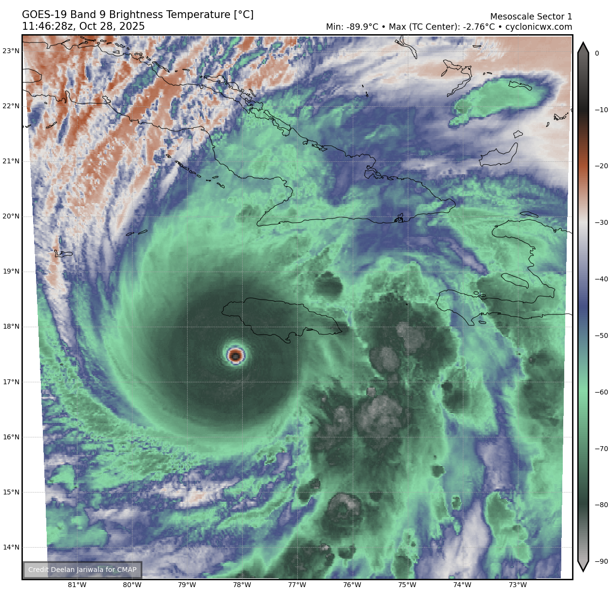
WV eye temp rose to -2.76C!

-
Getting a little forward motion giving it a little more warm water to strengthen? Hopefully hits in the middle where it's mostly goats and chickens.
-
Still overall AOB normal first 10 days... and models are "attempting" first flakes mix for I84 high terrain, esp 11/8-9. Nothing unusual.
-
We probably have to factor the summer drought stress during peak heating into the equation. This was the 4th driest and warmest summer here. Last year the summer was much wetter before the dry conditions last fall. Time Series Summary for NEW HAVEN TWEED AP, CT - Jun through Aug Click column heading to sort ascending, click again to sort descending. 1 1966 4.15 0 2 2022 4.29 0 3 2017 4.76 3 4 2025 4.99 0 Time Series Summary for NEW HAVEN TWEED AP, CT Click column heading to sort ascending, click again to sort descending. 1 2022 75.4 0 2 2024 75.2 0 3 2020 74.9 2 4 2025 74.5 0 5 2010 74.3 0
-
I was just thinking that.
-

Central PA Fall Discussions and Obs
Blizzard of 93 replied to ChescoWx's topic in Upstate New York/Pennsylvania
31 with frost in Marysville this morning. -
Strengthening at LF. Not good at all .
-
Central PA Fall Discussions and Obs
Blizzard of 93 replied to ChescoWx's topic in Upstate New York/Pennsylvania
I haven’t even signed back up for WB yet this season, Lol! The time is coming soon… -

Major Hurricane Melissa - 903mb - 175mph
40/70 Benchmark replied to GaWx's topic in Tropical Headquarters
System is a wonderful casestudy in how to navigate internal processess in the healthiest way possible. Wow. -
I am guessing somewhere around Treasure Beach is going to see the worst of it.
-

Central PA Fall Discussions and Obs
mahantango#1 replied to ChescoWx's topic in Upstate New York/Pennsylvania
you'll awaken the Blizz! -

Major Hurricane Melissa - 903mb - 175mph
Snowlover11 replied to GaWx's topic in Tropical Headquarters
Insane lightning in that eye wall. -
So far 2.25" of precip. Misty and chilly this morning. More rain expected tonight and tomorrow. We really needed this. The ground was hard as concrete and cracking in lots of areas with the drought.
-

Spooky Season (October Disco Thread)
Damage In Tolland replied to Prismshine Productions's topic in New England
Still could be some earlier gusts with children blown down -
Recon is gonna find a sub 900 storm.
-
2025-2026 ENSO
40/70 Benchmark replied to 40/70 Benchmark's topic in Weather Forecasting and Discussion
Very important point...personally, I feel folks get too carried away with SST maps because although somewhat of a feedback can develop to a degree, they are not the primary mechanism driving the pattern and are more of a reflection of it. I don't focus on that at all, aside from ENSO. -
Imagery actually suggests that the diameter of the eye has increased since the merger. Now we have a deep ring of lighting as well. I hate to say this, but it looks like Melissa is undergoing another period of intensification. Certainly somewhat better than a steady-state. Recon will be, *ahem* interesting...
-

Spooky Season (October Disco Thread)
CoastalWx replied to Prismshine Productions's topic in New England
Winds peak later at night. Gfs and euro look 50+ in gusts. -
Central PA Fall Discussions and Obs
mahantango#1 replied to ChescoWx's topic in Upstate New York/Pennsylvania
24 this morning, it just keeps getting colder -

Major Hurricane Melissa - 903mb - 175mph
hawkeye_wx replied to GaWx's topic in Tropical Headquarters
It is clear something favorable happened to the inner core structure in the last two hours. The CDO suddenly appears even stronger, the eye has grown in size, and there has been an explosion of intense lightning surrounding the eye. -
A nice steady rain is exactly what the doctor ordered.
-
What might be causing the more muted colors this year? It's nowhere near as dry as last fall.
-
2025-2026 ENSO
40/70 Benchmark replied to 40/70 Benchmark's topic in Weather Forecasting and Discussion
Yea, to be fair...really only one direction for them to go. -
2025-2026 ENSO
40/70 Benchmark replied to 40/70 Benchmark's topic in Weather Forecasting and Discussion
I mentioned that to him a couple of weeks ago. -
Sorry, not trying to be a smartguy. And no I do not have a ton of time to post, but I do read. And when you make a point about cooling SST's in NPAC as a slam dunk against a 2013 type blob, I felt it was very fair to give an accurate analysis. Personally, I do not think having a warm NPAC will equal some 2013-14 type winter, but that is beside the point. The NPAC on Oct 24th, 2013 is very similar to the current look with the exception that the current anomalies are warmer. Oct 24, 2013 Current And as far as when 2013 warmth returned tonthe Eastern NPAC it was not until the later part of DEC: NOV 14, 2013 DEC 15, 2013 Sorry, it ruffled your feathers.