All Activity
- Past hour
-

TROPICAL WAVE LOCATED IN CHAD, AFRICA (NOT 96L)
TampaMan replied to BarryStantonGBP's topic in Tropical Headquarters
Well, I'm glad I came here after a 5 month break (winter destroyed me, still in Richmond, VA) so I left the forums for a while. I'll keep peeking in here this week and next to see if anything major changes. Maybe I'll be the forum storm chaser if something does occur. Knowing my wife (she doesn't listen) she'd end up still wanting to go if a cat 5 hurricane was aimed directly at Tampa. Joking, kind of.... -

TROPICAL WAVE LOCATED IN CHAD, AFRICA (NOT 96L)
csnavywx replied to BarryStantonGBP's topic in Tropical Headquarters
Devil will be in the details as usual, but not the most friendly UL pattern to recurve TCs. Will need a weakness in the ridge that doesn't involve a cut-off low to the east of the central/plains ridge, sloppy development, or other smaller-scale (unresolvable at this distance) features to disrupt this as there's not much in the way of PV Streamers/TUTTs, the jet is displaced pretty far north and the WAR has a higher than normal chance of being an obstacle to recurvature.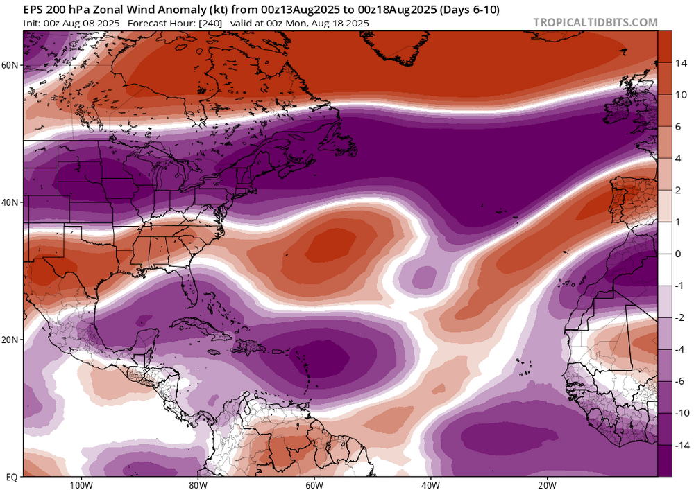

-
I sorta answered my own question going back to 1930, Blacksburg, Roanoke and Lynchburg all dropped 4 more places.
-
Looking at xMacis, the unweighted average mean temperature was 78.94F (average of 101 stations). In 2012, the unweighted average mean was 78.98F (average of 127 stations) and, in 2020, it was 79.00F (average of 109 stations). Looks like the gridded values for all three were identical. July 1934 was the hottest in Virginia during the 1930s. The unweighted average for that month was 78.83F, but adjustments for time of observation bias and equipment changes (MMTS a little cooler than CRS/LiG) bring it down somewhat. Even so, this year beats it straight up even using raw, unadjusted data. Also, you aren't factoring in that a lot of those sites have different months ahead of this one. It is certainly possible for a month to be record warm as a statewide average if it's near record warm across the state and the years ahead differ among the sites. This is looking at the statewide average.
-
Yes, especially since I will be on the shore the last two weeks of August. It has been 50 years or so since I had to evacuate while on vacation in OC.
-
I'm wearing one of my nests down before I move in for the kill.
-
 I would venture to say that big August heat is tougher to achieve than June-lower sun angle/decreasing day length has to have some sort of effect
 -
We're passing out of the solar max this weekend. It's going to get harder to get an official heat wave as the month ages onward. We've seen 90+ in early September, so heat can happen.. .but getting 3 days consecutive? sooner rather than later is climate preferred and for a reason. I wonder what is the latest official heat wave ( 3 consec days) to have occurred. Big heat ( > 95 F) ...I think I've seen that two or three times post Aug 20th.
-
If I recall.. he calls for a December to remember at least 4 out of every 5 Decembers lol
-
My guess is the Merrimack valley. They have been hot all summer.
-
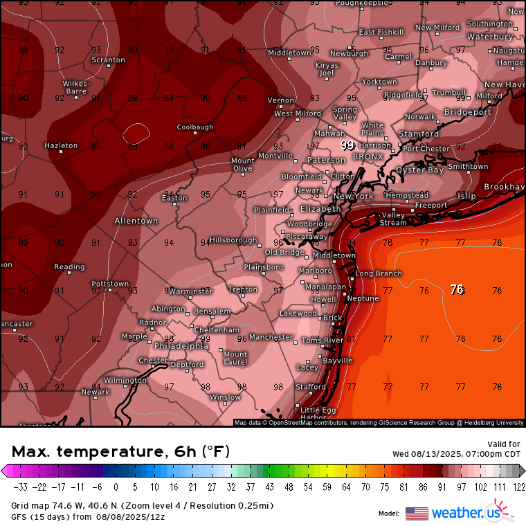
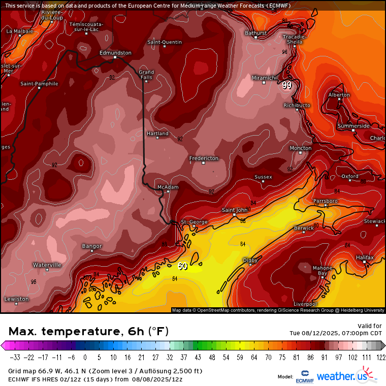
 I was talking about the August 10-17 period in that post. Thankfully, we have not seen the kind of drought which drove those 103° to 105° August and September heatwaves. All our 103°-105°+ heat since the record summer warmth began in 2010 has occurred in June and July. Those 40s and 50s heatwaves and a few earlier events occurred later in the season. Next week is looking like more of an over the top heat wave. Latest runs have more onshore flow. So both models showing 102° a few days ago for next Wednesday have cooled 3-4° down to a 98°-99° max. But it wouldn’t take much for somebody at the usual warm spots to reach 100°. So it continues to look like our peak heat in 2025 was back in June. With each succeeding heatwave moderating a bit as the season goes on. It’s impressive that both models have 98°-100° potential for parts of Maine and Canada. This is part of the record Canadian heat and drought resulting in the unprecedented wildfires in Canada. So with all this onshore flow in recent years, the JFK 32 days reaching 90° back in 2010 will be safe for another year.

-
Officially, a three-way tie between this past month, 2012 & 2020.
-

TROPICAL WAVE LOCATED IN CHAD, AFRICA (NOT 96L)
WxWatcher007 replied to BarryStantonGBP's topic in Tropical Headquarters
Yeah that's exactly it. The op models are always good for drama, but the ensembles are where it's at long range if one is really trying to analyze. The signal for something getting to the SW Atlantic is there IMO, but who knows about beyond that. The failed low off the SE coast is a prime example of this. Models kept driving it into the Carolina coast because they saw it being trapped under a ridge...until the guidance recognized a weakness that wasn't previously analyzed. -
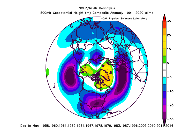
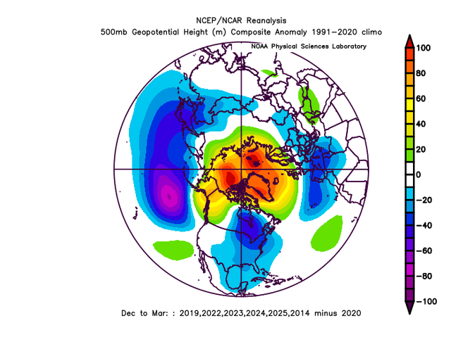
@Stormchaserchuck1 it’s not too surprising the mean anomaly you posted didn’t lead to snow most of the time. This look is decent but not really our snowy look this is the snowy season composite for BWI Note the negative in the TN valley. That’s the sweet spot. The pacific and high lat look is close but with the anomalies centered to our north it’s a cold dry look. We really want a negative anomaly centered to our SW on a winter mean to have a good chance of a snowy winter. Almost every decently big snowstorm has that. And it takes us multiple wasted good opportunities to score a hit most of the time. And we can’t get a snowy winter without hitting a couple times. So…it’s really hard to get a snowy winter without a negative on the seasonal means there. No mot impossible. It’s happened a few times. But betting on something that’s only happened a few times in 75 years isn’t a good bet. 90% of our snowy winters have a negative centered to our southwest for the season.
-
IF it is a record, it has just squeaked over previous mark. Looking across the state these are the numbers going back ONLY to 1980, mainly because that is what my numbers go back to. Lynchburg tied 4th highest, Roanoke 7th highest, Danville 6th highest, Blacksburg 1st, Dulles tied 4th, Reagan National 8th, Charlottsville 8th highest, Staunton 1st, Dale Enterprise tied 6th, Front Royal 2nd, Norfolk 11th, Richmond tied 8th highest, Williamsburg tied 5th, Emporia 4th, Wallops Island tied 8th. Now to the far western/southwestern part of the state, and these numbers are high. Wise 1st, Pennington Gap 1st, Pulaski 3rd, Richlands tied 1st, Wytheville 5th, Pearisburg 2nd, Abington 4th, Covington 3rd, Hot Springs 1st, Gathright Dam tied 3rd and my own in 4th. Yes, that is a cross section and not ALL locations, but are there enough 1's and 2's to overcome the 8's, 7's, 6's and 11's? And was it warmer back in the 30's? Just pondering.
-

2025-2026 ENSO
TheClimateChanger replied to 40/70 Benchmark's topic in Weather Forecasting and Discussion
-

TROPICAL WAVE LOCATED IN CHAD, AFRICA (NOT 96L)
GaWx replied to BarryStantonGBP's topic in Tropical Headquarters
That’s why I prefer looking at ensembles (mainly Euro and GFS), especially 5+ days out, to give hints of potential scenarios and which scenarios appear to be more likely. I also like to look at the operationals as their own ensemble in a sense within 7 days or so because by then the Euro, GFS, ICON, CMC, and UKMET are all available. As we know, we’re now still ~10-14 days away from any *potential* threat to the Conus. So, ensembles will probably tell us the most fwiw for a number of days to come. -
It’s still really far out. Worth a casual eye though.
-
I’m thinking some places do it Monday through Friday. Maybe even Sunday-Friday prob won’t happen here up in the Alps, but a great warm/hot stretch incoming
-
I could watch this 100x lol
-
TROPICAL WAVE LOCATED IN CHAD, AFRICA (NOT 96L)
WxWatcher007 replied to BarryStantonGBP's topic in Tropical Headquarters
Just remember that with time, errors on computer guidance increase exponentially. So at the very early stages like now when there’s no low level center and no vertically stacked system it’s going to be exceptionally hard for models or even ensembles to nail a long range forecast—anything beyond about 7 days imo. -
TROPICAL WAVE LOCATED IN CHAD, AFRICA (NOT 96L)
TampaMan replied to BarryStantonGBP's topic in Tropical Headquarters
I appreciate your post, sincerely. Thank you for going into a bit more detail for me so I can get some sort of relief temporarily. I'll keep an eye on it for the next few days, I forgot how this forum works.. even during winter people posted weenie maps of massive snow events that were 3 weeks out. -
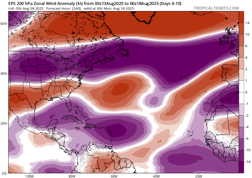
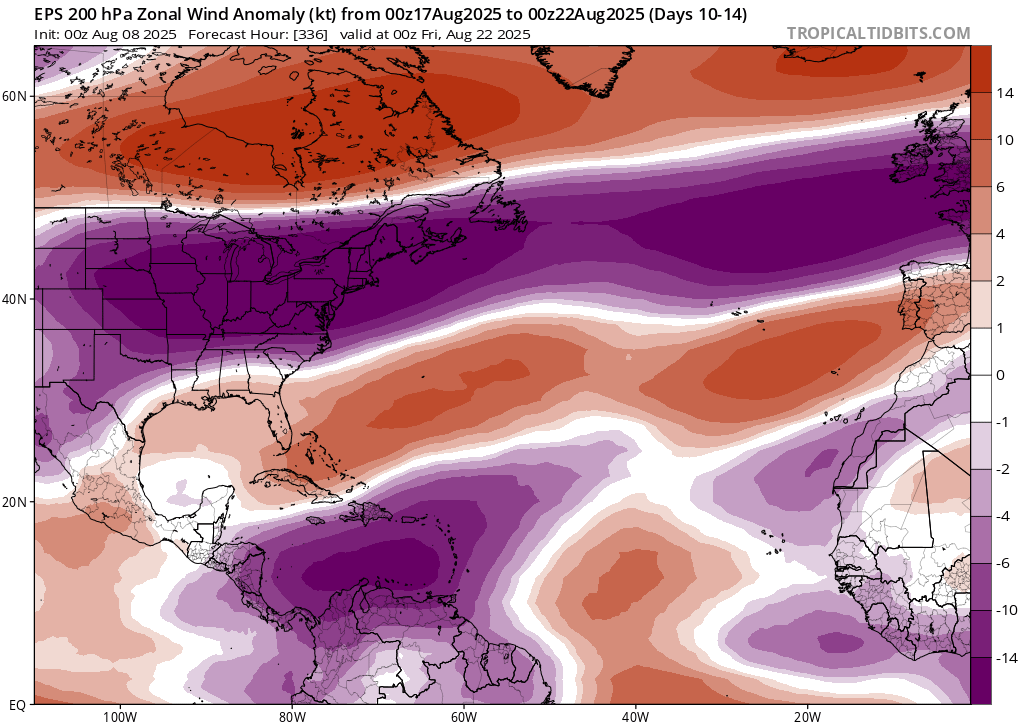
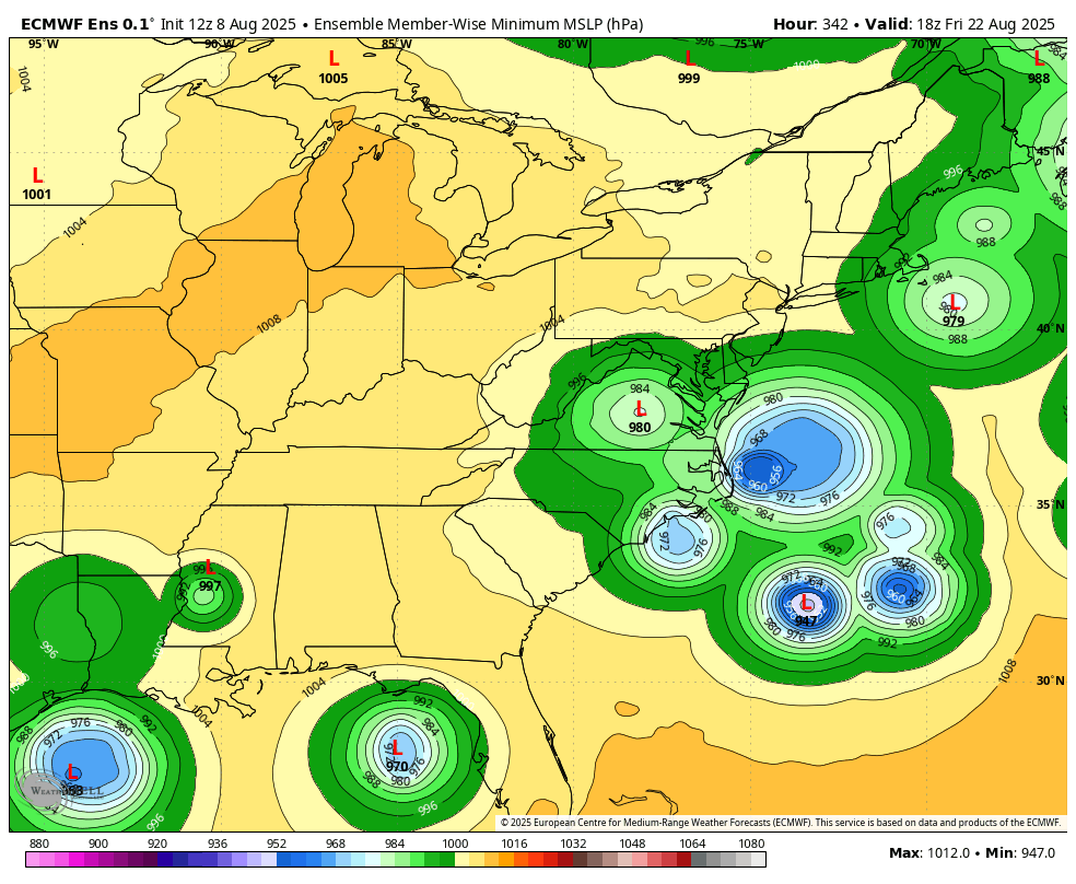
WB 12Z EPS flashing red for Mid Atlantic coast....

-
TROPICAL WAVE LOCATED IN CHAD, AFRICA (NOT 96L)
WxWatcher007 replied to BarryStantonGBP's topic in Tropical Headquarters
Good time to bust this out. We have an eternity to go. A lot will change.