All Activity
- Past hour
-

January 25/26 Jimbo Back Surgery Storm
NorthHillsWx replied to Jimbo!'s topic in Southeastern States
Sleet maps for central NC will be memorable for this run -

Possible Record Breaking Cold + Snow Sunday 1/25 - Tuesday 1/27
TriPol replied to TriPol's topic in New York City Metro
BIG HIT on the GFS!
-
I always check how many pages were added when I wake up. I knew after reading all of the banter by the time the gfs was done that something went sideways with the CMC and Euro. Hoping the trend stops this afternoon...glad I moved though.
-

January 2026 regional war/obs/disco thread
ineedsnow replied to Baroclinic Zone's topic in New England
6z GFS won't disappoint -

2025-2026 Fall/Winter Mountain Thread
ncjoaquin replied to Buckethead's topic in Southeastern States
The GFS did not get the message that our winter storm is gone. -
For folks in upstate and NC this is before the switch over happens. Points I-40 north see the switch over last. That is still a big dump of snow up front and matches what @HKY_WX was saying yesterday.
-
6z GFS throws us a bone. Still don't trust it but it gives most of us a good thump of snow before switching to a mixed bag of precip.
-
January 25/26 Jimbo Back Surgery Storm
NorthHillsWx replied to Jimbo!'s topic in Southeastern States
GFS drags ZR line to wake but doesn’t look like it makes it to Raleigh proper. Just a pounding sleet storm -
January 2026 regional war/obs/disco thread
ineedsnow replied to Baroclinic Zone's topic in New England
6z AI GFS came north a bit -
January 25/26 Jimbo Back Surgery Storm
NorthHillsWx replied to Jimbo!'s topic in Southeastern States
GFS ticked north slightly, but mostly unchanged -
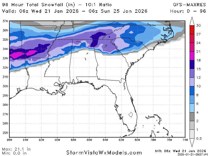
By hour 96 it's a sleet fest for NC and upstate. The GFS keeps those waves at 500 seperate and doesn't slingshot the low directly into the wedge. This looks more likely.
-
Models will be thrashing this out for the next 3-4 days. At times it will seem like we might get a lot of sleet, but I am sure that by Friday night or Saturday we will have a major snowstorm over the entire sub. Let's reel this one in.
-
I'm hoping the recon data the GFS ingested is giving us a more accurate solution
-
This may be the best gfs run we have seen… .
-

January 2026 regional war/obs/disco thread
moneypitmike replied to Baroclinic Zone's topic in New England
I can't believe Mattapoisett will be getting double digits and I'll have nothing here in Maine. We're doing okay overall up here, but it will be painful sitting this one out. Congrats you southerners. -
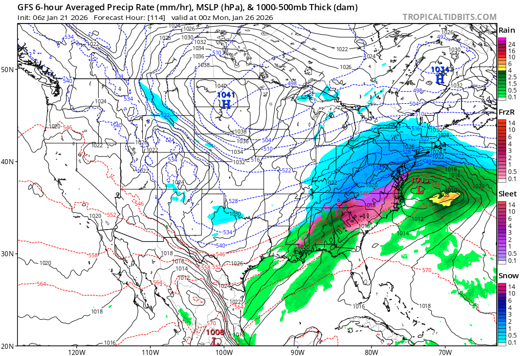
Out to 90 the 6z GFS keeps NC all snow. Upstate area of SC is also snow but on the edge. GA mainly ZR.
-
January 2026 regional war/obs/disco thread
ineedsnow replied to Baroclinic Zone's topic in New England
6z ICON was looking good -
6z GFS looks better than the Euro out to 84. Front end thump of snow inbound for upstate SC and most of NC.
-
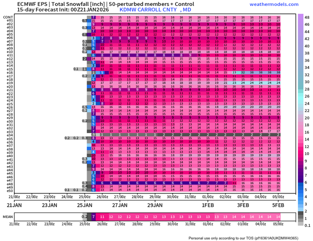
One thing to see that wild. Almost every member shows over 10”.
-

January 2026 regional war/obs/disco thread
Damage In Tolland replied to Baroclinic Zone's topic in New England
1-3 tonight . Feet Sunday/ Monday/ Tuesday -
I see we’ve had a north trend where we flirt with mixing or do mix before the storm ends. I knew it. But still a good front ender.
-
January 25/26 Jimbo Back Surgery Storm
NorthHillsWx replied to Jimbo!'s topic in Southeastern States
@eyewall the 6” snow probability for Raleigh is at 0% on the 0z EPS for Raleigh. We’re totally cooked -
January 25/26 Jimbo Back Surgery Storm
NorthHillsWx replied to Jimbo!'s topic in Southeastern States
ICON much more amped. Big jump north again. Basically no snow in NC even at border. Holds the wedge, crippling ice. -
Eric Webb getting served crow via 0z models.
-
Good thump for most of the sub, 8-12” before the lowlanders SE of 95 would have mixing issues. Transfers to a low off VA near the end of the run, but cuts off for most at hour 120. Not at the computer for nice graphics, trying to log into wxmodels site to paste a total QPF/snow, but hasn’t loaded there yet.