All Activity
- Past hour
-
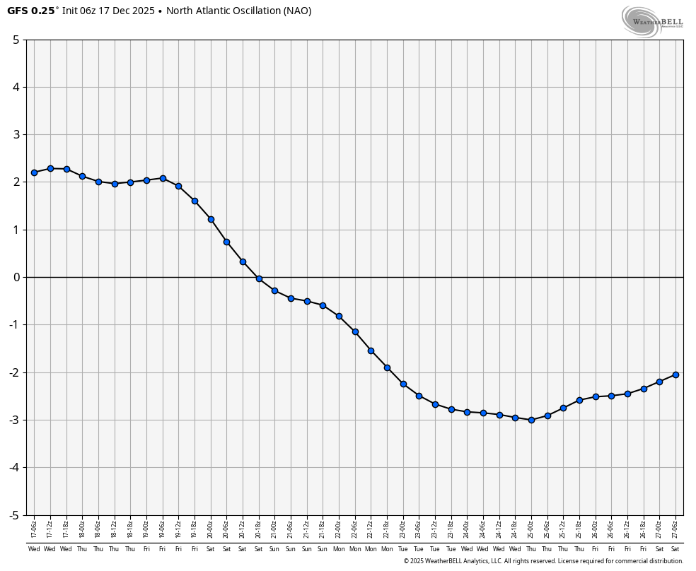
So if anyone knows, what exactly is the below? I do not see a true -NAO but rather a large east coast ridge facilitated by a deep RNA. To me this is NOT a scary "SE ridge linking up to a negative NAO". I am sure this has happened MANY times in the past. Not sure how the rest of the winter shaped up in the past. A good deteriming factor of whether or not it is a true neg nao would be if it retrogrades to a neg AO or not.
-
Backed off your -2 to -3 finish from last week I see. We’ll probably finish around -5 when the month is done, as bulk of the warmth stays to our S&W.
-
Thanks. How about the Gefs and Eps if you have them handy?
-
EPS is a bit better, GEFS look worse.....a lot of chaos post 10 days, might be something there in the 10-12 day range with the brief spike in PNA, dip in the NAO?
-

December 2025 regional war/obs/disco thread
weatherwiz replied to Torch Tiger's topic in New England
There is going to be lots of precipitation around which will hold back gusts overall. If we had little precip ahead of the main line and even got some cloud breaks...we would rip pretty good. This could happen locally, probably better shot towards interior eastern Mass. But I also think there is room for thunderstorms embedded within the line moving into far eastern CT, RI, eastern Mass and that will have to be watched. -
WB 6Z GFS NAO is forecasted very negative around Christmas.

-
This is a disappointing front load if that's the case.
-

December 2025 regional war/obs/disco thread
SouthCoastMA replied to Torch Tiger's topic in New England
Id like to see the Euro AI look better again for 24th/25th. AI ensembles look any different? -

December 2025 regional war/obs/disco thread
40/70 Benchmark replied to Torch Tiger's topic in New England
9/10 times you can take the under on those clown gusts and be correct. -
December 2025 regional war/obs/disco thread
weatherwiz replied to Torch Tiger's topic in New England
Bufkit isn't terribly impressive in terms of wind gust potential Friday. Very weak lapse rates present and a saturated profile. Sustained winds though looks solid...could be sustained 30-35 across the Cape. This isn't to say there is 40-50 mph gusts potential but we'll need convection and need to see some drying within some of the profiles. The typical elevated areas will gusts well -
They’re phasing, just 300 miles to our west and east.
-
December 2025 regional war/obs/disco thread
40/70 Benchmark replied to Torch Tiger's topic in New England
-
December 2025 regional war/obs/disco thread
40/70 Benchmark replied to Torch Tiger's topic in New England
..or our best storms from phases, god forbid.... -
timber goes the trough in the west.....I feel like we have seen this before and know how it ends, doesn't mean it won't snow but sure does make it difficult
-
I should have said IMBY which is SW CT. Central park also, which only received 1.4 inches of snow before turning to rain (this year they had a grossly undermeasured 2.9 inches AND a runaway HEI (they were 37 at the onset while the central Jersey coast had 34 lol)). To me it was the most disappointing BECAUSE it was historically cold and ended up with a rain storm in the middle of single digit temps before and after storm lol.
-
December 2025 regional war/obs/disco thread
weatherwiz replied to Torch Tiger's topic in New England
I feel like too we haven't had "classic" blocking...but I think a big part of it too is blocking is much more beneficial for southern streams working up the coast. blocking with northern streams just results in one of two things, which you mentioned, cutting if the s/w is too strong and shredding the s/w or sending south if it is too weak. -
After dropping back into the mid 20's early last evening I played a yo-yo game on temps with a small steady climb. It seemed quite dependent on the cloud cover overhead too. 33.5 at 7 am here with mostly cloudy skies and an absolutely stunning red/pink sky to the east as dawn broke.
-
Based off what ?
-
nothing like posting some evidence to back up your guess...........
-
dude, it’s gonna be in the mid 30s, 40s or 50s for the rest of the month. some of you guys are living in fantasy land. Id love it to happen, but the rest of December looks like toast
-
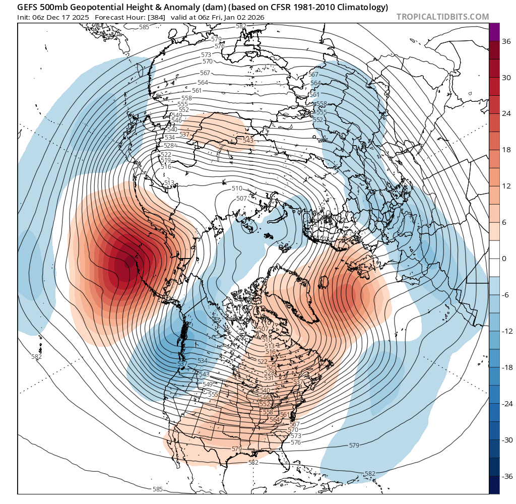
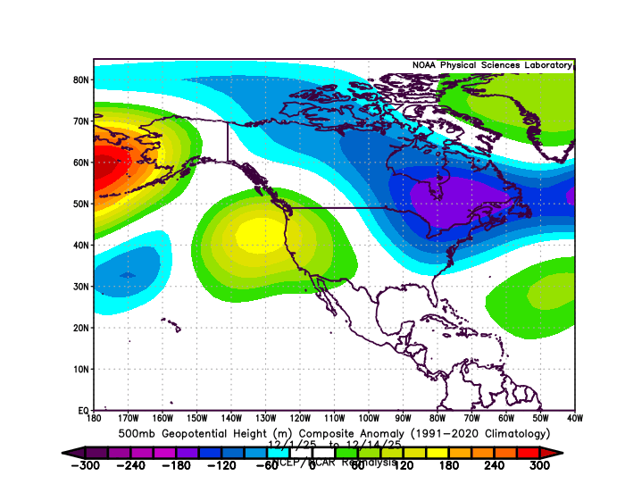
This is going to be one of the strongest -WPO blocks that we have seen for the month of December. But it’s a different configuration of other factors that we have previously seen with December -WPOs in the past. This one has a much more amplified Pacific Jet into the PACNW and BC than we have seen before with the historic flooding in those areas. Plus we have an out of phase +EPO and very strong ridge onto the Western US. Unique December 2025 500 mb and Pacific Jet stream pattern compared to previous very strong -WPO patterns
-
With the NAO negative - the WPO Negative and MJO hanging around somewhere in Phase 8 - how do you get anywhere close to 60 ?
-
Up here we ended up with above average snowfall and some snow from the "bust" so actually a decent year IMBY.
-
Wash, rinse, repeat! Same holidays pattern as always!
-
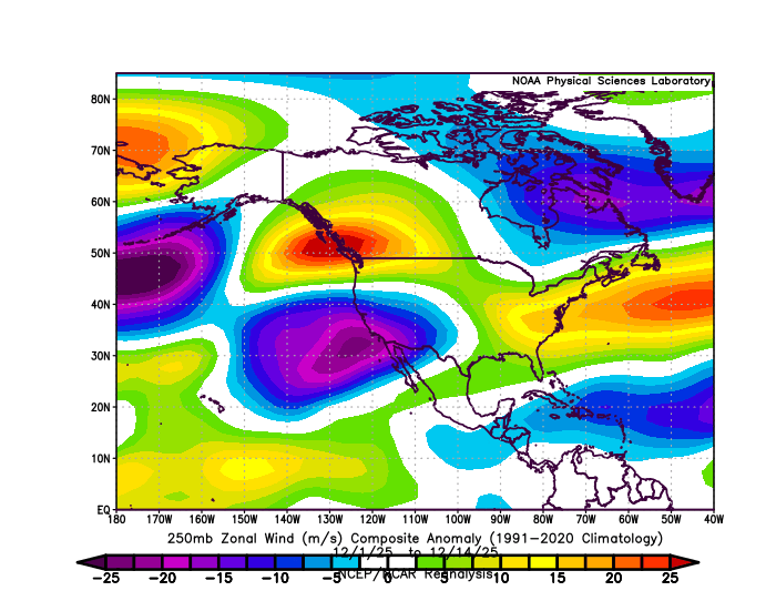
We are and have been in a classic, canonical La Niña pattern since September 1st. It’s been fitting a “front-end loaded” Niña to a tee up to this point in time…..