All Activity
- Past hour
-

E PA/NJ/DE Autumn 2025 Obs/Discussion
Fields27 replied to PhiEaglesfan712's topic in Philadelphia Region
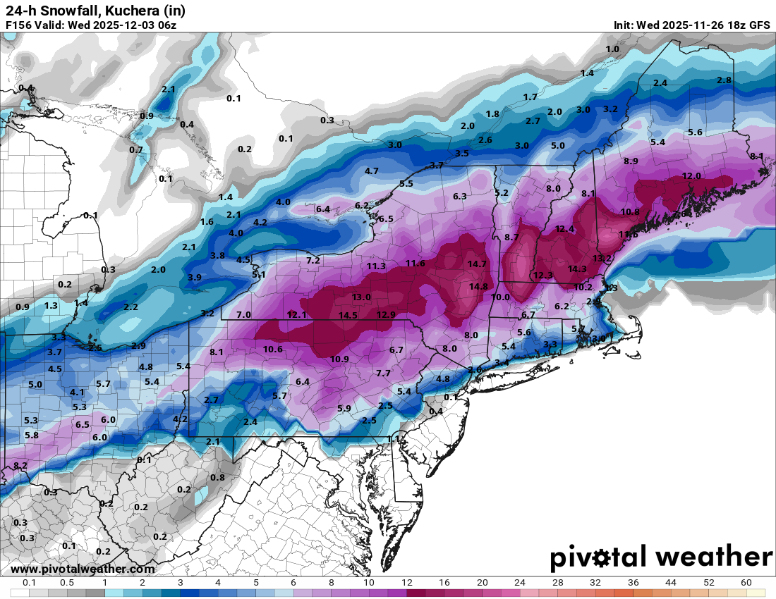
Happy hour GFS doubles down and is really amped. Rainy outcome. Idk about you guys but I'd much rather see an amped solution this far out. Edit: Still a nice thump of snow NW of 95 verbatim. Sent from my SM-S938U using Tapatalk -

Central PA Fall Discussions and Obs
canderson replied to ChescoWx's topic in Upstate New York/Pennsylvania
Winds are here -
considering the other models at 12z I think it's probably good we got a run coming in hot.
-

December 2025 regional war/obs/disco thread
HoarfrostHubb replied to Torch Tiger's topic in New England
Wagons north -
really different solutions between the GFS and most other models - IMO GFS is too amped and will trend further south and east similar to the benchmark solution it had previously.... and other models will trend west closer to that solution....18Z is a leftover 12Z solution anyways - newer data at 0Z
-
in albany for the next month and a half. 18z GFS is a dream
-
Yep, we don’t need a major adjustment to get snow
-
-
At 120hrs, we're all still in the game. That's really all that can be taken at this point, and that's a decent place to be for a 12/2 threat.
-

December 2025 regional war/obs/disco thread
brooklynwx99 replied to Torch Tiger's topic in New England
personally, given the pattern, i would find something suppressed and washed out more likely than something as amped as the GFS -
The mountains get snow this run
-
Actually might even be close to the mix line here
-

December 2025 regional war/obs/disco thread
Damage In Tolland replied to Torch Tiger's topic in New England
Rains to Maines -
Textbook snowstorm for here
-
Better TPV push and it might be okay. I like seeing a stronger storm… one day that’ll work out for us.
-
Way amped
-
What difference 12 hours makes rainy this run
-
18z GFS
-
Yeah, gfs has been trending more and more amped the last 4-8 runs. Mostly rain for us. We’ll see if this breaks the deamplification trend that’s been around for 2 years, or if that gets us back in the game.
-
I'll be 40 in a couple months and seems like yesterday I was 21
-
Gfs continues to be the most amped model. Inland does really well. Rain for the coast.
-
It’s raining DC at 138, mixy further west. Might flip eventually
-
Could be, idk yet. You may be further ahead of me.
-
At 126hrs, there's a surface High of 1029 in northern Iowa that wasn't ther at 12z. That's good.
-

December 2025 Short/Medium Range Forecast Thread
jaxjagman replied to John1122's topic in Tennessee Valley
GTH Outlook Discussion Last Updated - 11/25/25 Valid - 12/03/25 - 12/16/25 Recent observations of tropical convection and the global tropical circulation indicate that the Madden-Julian Oscillation (MJO) remains active, with the enhanced convective phase over the West Pacific. Little eastward propagation was evident on the RMM-based MJO index during the past two weeks, however, fluctuations in amplitude are indicative of interference from other modes of variability. The biggest disruptor to the ongoing MJO evolution is the low-frequency La Niña base state, which is preventing upper-level easterlies, low-level westerlies, and widespread convection from crossing the equatorial central Pacific. Enhanced convection is crossing the central Pacific away from the Equator, however, especially along the South Pacific Convergence Zone (SPCZ) region. Time-longitude analyses of the low-level zonal wind field reveals two distinct features propagating eastward: a slowly evolving envelope of westerly anomalies that has progressed from the Indian Ocean in October to the far western Pacific by mid- to late November, and a faster moving signal, likely Kelvin wave activity, that is circumnavigating the globe. As this latter signal comes into phase with the slower evolving signal, westerly wind bursts have occurred, followed by a period of increasing disorganization. Dynamical model forecasts are in good agreement that a period of constructive interference between these two signals will occur in late November and early December, resulting in a disruption of the La Niña trade wind regime over the west-central Pacific, and a rapid amplification of the RMM-based MJO index in Phase-7. Beyond this period, the faster moving mode becomes more unpredictable and may not well capture an easterly phase of the Kelvin wave, but the slower-evolving low-level westerlies are favored to continue impacting the Pacific basin into mid-December. A potential second enhancement of the MJO signal is clearly depicted in both the GEFS and ECMWF model systems during late December over the East Pacific, likely tied to another period of constructive interference between the slowly propagating signal and the Kelvin wave activity. Based on this guidance, the MJO is favored to remain active, and may become the dominant contributor to the global tropical convective pattern during early December. Pacific MJO events teleconnect well with the midlatitude circulation during the Boreal winter season, and may contribute to a reinforcement of ridging across western North America and troughing over eastern North America. https://www.cpc.ncep.noaa.gov/products/precip/CWlink/ghaz/index.php