All Activity
- Past hour
-

E PA/NJ/DE Summer 2025 Obs/Discussion
Physicsteve replied to Hurricane Agnes's topic in Philadelphia Region
Power went out right before 6p Thursday and came back on today just before 3p. AC doesnt stand much of a chance today so hoping it “cools” off enough tonight to make some headway before the triple digits make an appearance. Seen yesterday west of Pennington. The thunder and lightning were average but wind was no joke.
-
If I knew for a fact their wouldn't be any power issues I would care if it got very hot every once in awhile. That's were my biggest concern lies.
-
not *very bad* but a time to celebrate a once a decade occurrence! you should be a fan of weather extremes!
-
Stay hydrated friends.

-
 around the same time it hit 90 here and then the temperature dropped 4 degrees at 3 when the sea breeze came in
 -
I'm thinking the seabreeze on Monday afternoon knocks down the heat building effects. We are not going to see 90 degrees at 2AM early Tuesday morning like models were showing several days ago. No doubt if the Euro is right though Tuesday will be very bad.
-
it was 90 here at 2:30 pm and then the sea breeze came in here around 3 pm and knocked temperatures down 4 degrees. the temperature spike occurs right before the sea breeze comes in sounds a lot like the heaviest snow / largest snowflakes occurring right before the changeover hits.
-
Preliminary Local Storm Report...Corrected National Weather Service Baltimore MD/Washington DC 308 PM EDT Sat Jun 21 2025 ..TIME... ...EVENT... ...CITY LOCATION... ...LAT.LON... ..DATE... ....MAG.... ..COUNTY LOCATION..ST.. ...SOURCE.... ..REMARKS.. 0215 PM Tornado Odenton 39.06N 76.70W 06/18/2025 Anne Arundel MD NWS Storm Survey Corrected for time/date. NWS Storm Survey confirmed an EF-0 tornado briefly touched down in Odenton, MD at approximately 215 pm, with peak winds estimated at 80mph. Path length was 0.1 miles and width was 75 yards. Numerous trees were snapped and uprooted, some onto homes along Sunny Chapel Road. && Corrected event date...event time...remarks Event Number LWX2505631
-
I think somebody in the area has a shot at their first June 105° reading on Tuesday since this will be a 3 day heat build. The Euro was correct with the low 90s today as the GFS only had upper 80s. The heat away from the local sea breezes will begin ramping up tomorrow and build higher each day. My guess is that the best shot for 105° will be around Newark and Corona, Queens Tuesday. Maybe even an area we don’t expect further east into Nassau or NW Suffolk where the best compressional warming occurs right along the sea breeze front.
-
It cuts deep because it’s so true. Today is great though. Getting long overdue work done outside, enjoying the summer warmth.
-
We’re always watching , hoping .. always knowing , failing
-
I agree, but we’ll see if we can get lucky and make something happen.
-
Preliminary Local Storm Report National Weather Service Baltimore MD/Washington DC 250 PM EDT Sat Jun 21 2025 ..TIME... ...EVENT... ...CITY LOCATION... ...LAT.LON... ..DATE... ....MAG.... ..COUNTY LOCATION..ST.. ...SOURCE.... ..REMARKS.. 0440 PM Tornado Odenton 39.06N 76.70W 06/19/2025 Anne Arundel MD NWS Storm Survey NWS Storm Survey confirmed an EF-0 tornado briefly touched down in Odenton, MD at approximately 440 pm, with peak winds estimated at 80mph. Path length was 0.1 miles and width was 75 yards. Numerous trees were snapped and uprooted, some onto homes along Sunny Chapel Road. && Event Number LWX2505631
-
 Looks like max was 91 degrees at 2:25.
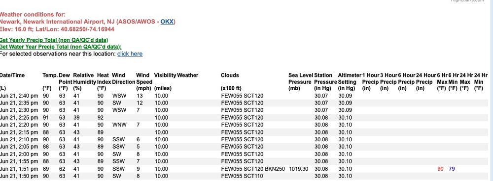
-
URGENT - WEATHER MESSAGE National Weather Service Baltimore MD/Washington DC 244 PM EDT Sat Jun 21 2025 MDZ003-VAZ027>031-WVZ052-053-220245- /O.NEW.KLWX.HT.Y.0001.250622T1600Z-250623T0000Z/ /O.NEW.KLWX.XH.A.0001.250623T1500Z-250624T0100Z/ Washington-Shenandoah-Frederick VA-Page-Warren-Clarke-Berkeley- Jefferson- 244 PM EDT Sat Jun 21 2025 ...HEAT ADVISORY IN EFFECT FROM NOON TO 8 PM EDT SUNDAY... ...EXTREME HEAT WATCH IN EFFECT FROM MONDAY MORNING THROUGH MONDAY EVENING... * WHAT...For the Heat Advisory, heat index values up to 103 expected. For the Extreme Heat Watch, dangerously hot conditions with heat index values up to 107 possible. * WHERE...In Maryland, Washington County. In Virginia, Clarke, Frederick, Page, Shenandoah, and Warren Counties. In West Virginia, Berkeley and Jefferson Counties. * WHEN...For the Heat Advisory, from noon to 8 PM EDT Sunday. For the Extreme Heat Watch, from late Monday morning through Monday evening. * IMPACTS...Heat related illnesses increase significantly during extreme heat and high humidity events. Hot temperatures and high humidity may cause heat illnesses. PRECAUTIONARY/PREPAREDNESS ACTIONS... Drink plenty of fluids, stay in an air-conditioned room, stay out of the sun, and check up on relatives and neighbors.
-
URGENT - WEATHER MESSAGE National Weather Service Baltimore MD/Washington DC 244 PM EDT Sat Jun 21 2025 MDZ502-WVZ050-051-055-502-504-220245- /O.NEW.KLWX.HT.Y.0001.250622T1600Z-250623T0000Z/ Central and Eastern Allegany-Hampshire-Morgan-Hardy-Eastern Grant- Eastern Mineral- 244 PM EDT Sat Jun 21 2025 ...HEAT ADVISORY IN EFFECT FROM NOON TO 8 PM EDT SUNDAY... * WHAT...Heat index values up to 102 expected in the valleys. * WHERE...In Maryland, Central and Eastern Allegany County. In West Virginia, Eastern Grant, Eastern Mineral, Hampshire, Hardy, and Morgan Counties. * WHEN...From noon to 8 PM EDT Sunday. * IMPACTS...Hot temperatures and high humidity may cause heat illnesses. PRECAUTIONARY/PREPAREDNESS ACTIONS... Drink plenty of fluids, stay in an air-conditioned room, stay out of the sun, and check up on relatives and neighbors.
-
URGENT - WEATHER MESSAGE National Weather Service Baltimore MD/Washington DC 244 PM EDT Sat Jun 21 2025 DCZ001-MDZ004>006-008-011-013-014-016-503>508-VAZ053>055-502-505-506- 526-527-220245- /O.NEW.KLWX.XH.A.0001.250623T1500Z-250624T0100Z/ District of Columbia-Frederick MD-Carroll-Northern Baltimore- Cecil-Southern Baltimore-Prince Georges-Anne Arundel-Charles- Northwest Montgomery-Central and Southeast Montgomery-Northwest Howard-Central and Southeast Howard-Northwest Harford-Southeast Harford-Fairfax-Arlington/Falls Church/Alexandria-Stafford- Southern Fauquier-Western Loudoun-Eastern Loudoun-Northwest Prince William-Central and Southeast Prince William/Manassas/Manassas Park- 244 PM EDT Sat Jun 21 2025 ...EXTREME HEAT WATCH IN EFFECT FROM MONDAY MORNING THROUGH MONDAY EVENING... * WHAT...Dangerously hot conditions with heat index values up to 110 possible. * WHERE...Washington DC, and portions of central and northern Maryland, and northern Virginia. * WHEN...From late Monday morning through Monday evening. * IMPACTS...Heat related illnesses increase significantly during extreme heat and high humidity events. PRECAUTIONARY/PREPAREDNESS ACTIONS... Drink plenty of fluids, stay in an air-conditioned room, stay out of the sun, and check up on relatives and neighbors.
-
wait you have JFK listed twice Tony, actually three times but only with two different temperatures lol
-
90 here at 2:30 perhaps JFK gets it in between hours
-
it hit 90 here at 2:30 nice offshore breeze
-
Uptick in cloud cover here recently, even saw a stray shower on the radar NW of here and a boundary near the beaches and in lower DE.
-
Most likely scenario is no storms but debris clouds ruining big heat tomorrow
-
Glenmoore with records back to 2012 has recorded 7 heat waves in the last 13 summers. Those occurring in 2013 / 2016 / 2020/ 2022 and 3 times just last summer in 2024.
-

E PA/NJ/DE Summer 2025 Obs/Discussion
ChescoWx replied to Hurricane Agnes's topic in Philadelphia Region
Glenmoore with records back to 2012 has recorded 7 heat waves in the last 13 summers with those occurring in 2013 / 2016 / 2020 / 2022 and 3 times just last summer in 2024. -
Timing sucks. Too bad it couldn’t come through 4-6 hrs later. It slowed a bit too.


