All Activity
- Past hour
-
Is this going to be another event that poos the bed for 95 and east?
-
Right at 1/2" here mtd, 0.0 for the past 10 days. heard thunder on and off all weekend it seemed like but your screw zone has engulfed me finally. 1-3" weekend totals all around me.
-
WPC seems to have cut back rainfall of total significantly with their latest afternoon update in the 7-Day. Haven't had a chance to look at the models. Do the models concur with less rainfall for our area?
-

September 2025 OBS-Discussion centered NYC subforum
donsutherland1 replied to wdrag's topic in New York City Metro
It was. October 1895 was very cool. -
0.01" at home.
-

September 2025 OBS-Discussion centered NYC subforum
LibertyBell replied to wdrag's topic in New York City Metro
There's a hurricane that's going to hit the Azores, they're going in the wrong direction lol. -
September 2025 OBS-Discussion centered NYC subforum
LibertyBell replied to wdrag's topic in New York City Metro
Just like back in 1895 and 1896 (I kid but you know what I mean lol). -

September 2025 OBS-Discussion centered NYC subforum
SnoSki14 replied to wdrag's topic in New York City Metro
Boring zzzz It can be warm but the weather has been a snooze fest. Give me a hurricane or something -
September 2025 OBS-Discussion centered NYC subforum
LibertyBell replied to wdrag's topic in New York City Metro
NYC: 97 (1895) now THIS is pretty crazy lol -
September 2025 OBS-Discussion centered NYC subforum
LibertyBell replied to wdrag's topic in New York City Metro
it was 97 on this date back in 1895, I wonder if that was our latest upper 90s on record Don (upper 90s = 97-99), we had some crazy heat in the 1890s (a 10 day heatwave in 1896 too). -
September 2025 OBS-Discussion centered NYC subforum
LibertyBell replied to wdrag's topic in New York City Metro
Looks like October might be warm and dry just like it was last year. -
September 2025 OBS-Discussion centered NYC subforum
donsutherland1 replied to wdrag's topic in New York City Metro
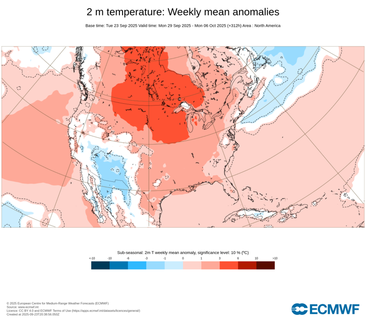
Probably not. I am fairly sure that most or all of the NYC region have already seen their last 90s. In fact, there has been a big change in the ECMWF weeklies for the week of September 29-October 6 with the new run that just came out. 9/22 Run: 9/23 Run: Beyond that, all the weeks are warmer than the were on the preceding run.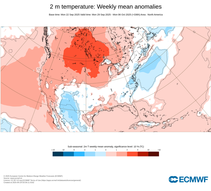
-
September 2025 OBS-Discussion centered NYC subforum
LibertyBell replied to wdrag's topic in New York City Metro
This is much better than 50s with wind, omg I hate that weather. -
September 2025 OBS-Discussion centered NYC subforum
LibertyBell replied to wdrag's topic in New York City Metro
Maybe this isn't the last 80s just yet Don? -

Central PA Summer 2025
Mount Joy Snowman replied to Voyager's topic in Upstate New York/Pennsylvania
Looks like I got trained pretty good at my place, looking forward to checking the gauge when I get home. -

September 2025 OBS-Discussion centered NYC subforum
winterwarlock replied to wdrag's topic in New York City Metro
86/69/90 -
Getting another heavy shower now.... Sun back out. We were on the southern edge. .23.
-
Two brief but heavy downpours this afternoon, followed immediately by bright sunshine.
-
Basically a torrential downpour. No T&L yet
-

September 2025 OBS-Discussion centered NYC subforum
the_other_guy replied to wdrag's topic in New York City Metro
I mean hoodies and shorts can get you thru mid Dec if youre a dude -
The Euro Weeklies ensemble and control is hinting at the first strong cold fronts of the season beginning in mid-October. Waaaay out there(huge grains o salt), the ensemble is hinting at sharp turn to colder during November w/ a PNA ridge popping out West and hooking into the AO region. Base warm pattern until mid Oct, transition w/ retrograding ridge into the West, and then looks like potential cold for November.
-
I can’t see the Catoctin’s right now.
-

September 2025 OBS-Discussion centered NYC subforum
uofmiami replied to wdrag's topic in New York City Metro
80.5 in Muttontown & 80.2 in Syosset today. -
The Uk agrees with the Euro. The cutoff low brings all the rain to WNC and tries to funnel in those system(s) of the SE coast but they get too close and a weird fujiwara effect happens. Going to be some wild weather maps next week.
-
September 2025 OBS-Discussion centered NYC subforum
donsutherland1 replied to wdrag's topic in New York City Metro
Much of the region saw the mercury rise into the 80s today. The warmth will be trimmed in coming days. A weak cool front will trigger some scattered showers overnight. Afterward, the front will stall near the region tomorrow. Several waves of low pressure will move along the front bringing showers and rain Thursday from Saturday. A general 0.50"-1.50" rainfall is likely during this period. Some locations cuold see higher amounts in excess of 2.00". Above normal temperatures will continue through at least the coming weekend. The ENSO Region 1+2 anomaly was 0.0°C and the Region 3.4 anomaly was -0.4°C for the week centered around September 17. For the past six weeks, the ENSO Region 1+2 anomaly has averaged -0.03°C and the ENSO Region 3.4 anomaly has averaged -0.38°C. La Niña conditions will likely develop during mid- or late-autumn. The SOI was +2.50 today. The preliminary Arctic Oscillation (AO) was +1.151 today. Based on sensitivity analysis applied to the latest guidance, there is an implied near 66% probability that New York City will have a warmer than normal September (1991-2020 normal). September will likely finish with a mean temperature near 69.6° (0.4° above normal). Supplemental Information: The projected mean would be 1.6° above the 1981-2010 normal monthly value.


