All Activity
- Past hour
-

2025-2026 ENSO
CP_WinterStorm replied to 40/70 Benchmark's topic in Weather Forecasting and Discussion
¡Muchas gracias! -

2025 Atlantic Hurricane Season
BarryStantonGBP replied to BarryStantonGBP's topic in Tropical Headquarters
In your dreams -

2025 Spring/Summer Mountain Thread
Met1985 replied to Maggie Valley Steve's topic in Southeastern States
Yeah that storm washed Canton out. Looks really unsettled in general in our area. -
https://s2s.worldclimateservice.com/climatepanel/ Click on 2nd thumbnail from top.
-
Just missing the bulk of it to the north.
.thumb.jpg.930375b015236309ad613712877df1cf.jpg)
-
God awful in Maine. You actually got lucky. A lot higher rain totals around.
-
All across the MDR SSTs are ~1C cooler than to the N! This if it persists should keep a relative lid on TCs in the tropics themselves this year.
-

Invest 91L--70% Development Odds
WxWatcher007 replied to WxWatcher007's topic in Tropical Headquarters
Looks like a pretty good wind shift to me. Probably will start getting advisories at 5 for a TD.- 1 reply
-
- 1
-

-

2025 Spring/Summer Mountain Thread
WxKnurd replied to Maggie Valley Steve's topic in Southeastern States
Been listening to it thunder south of here since like noon, storm around Cantsn may finally creep over the mountain but I’d be fine if it didn’t. Felt good for late June on the front porch this morning. -
Yeah, 80 on the 4th is terrible.
-
A perfect 4th is probably mostly sunny skies, 85/64 or thereabouts. Some years ago I was on a hill watching fireworks and there was a thunderstorm way off in the distance. Perfect evening, fireworks booming with actual long distance lightning strikes illuminating the storm. That was about as good as it gets.
-
I definitely expected it to be better by now. Me ftl. Despite warm front passing still meh
-
Hope these fizzle (CPA) otherwise about 3 - 6 hours for arrival if, assuming nothing else pops.
-
83 / 71 here Partly cloudy
-
Nothing better than a scorcher 4th, looks like shit as-is but hopefully modifies some like Dit mentioned.
-

July 2025 Obs/Disco ... possible historic month for heat
OceanStWx replied to Typhoon Tip's topic in New England
-
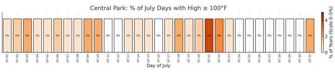
That is correct, in fact it has not even hit 99 F from July 24 to 28. (99F on July 29, 1949). There's a similar lull in August from 16th to 25th with highest value 97F and even more pronounced, records of only 92F and 94F on Aug 23rd-24th. After August 25th the records generally pick up considerably although most are in a few years like 1948, 53, 73 and later 1881. Perhaps these are expectable random variations that will fill in after 250-300 years of records.
-
Seriously what's wrong with that? It's not like it's going to be 48° at noon. Hot 4th of July's suck unless you're at the beach. Lots activities are in fields and city centers .You don't want to be roasting.
-
DZ, 55/54F, Another crappy Saturday, 0.47" of rainfall
-
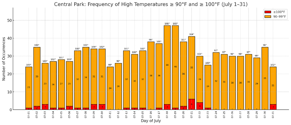
Here's the for 100° days: Here's the distribution of 90°+ days, 100°+ days, and daily record highs:
-
GEFS and EPS With a sprawling Atlantic ridge, we may need to watch to see if something gets steered northward/NW if a system develops off the SE coast. Usually with a trough off the coast that creates enough of a weakness to allow for a SE homebrew system to escape, but if the ridge builds in fast enough it could cut off an escape route. The 12z Euro shows this with a weak system getting pushed into the SE. On the GFS, the system develops in the Gulf and heads west, also illustrating the potential blocking power of the ridge.
-
Yeah that’s awful and will definitely modify getting closer in
-
2025 Atlantic Hurricane Season
WxWatcher007 replied to BarryStantonGBP's topic in Tropical Headquarters
Just started a thread for 91L. It's also worth watching the Gulf and SE Coast next week for some homebrew potential. Both the GFS and Euro ensembles and operational models show a trough dipping in the south leading to TC genesis toward the latter part of next week. That's a climatologically favored genesis method, in addition to being in a climatologically favored region for TC development this time of year. It's also basically the only part of the basin not the subtropics that's warmer than normal. -
Also isn't there a whole week at the end of July when NYC has never hit 100 (I think it's July 24-30).
-
That's perfect for Easter or Memorial Day, definitely not July 4th.


.jpg.e99f83b6ee1cc0d06878749bcdeb6bfe.jpg)


