All Activity
- Past hour
-

July 2025 Discussion-OBS - seasonable summer variability
LibertyBell replied to wdrag's topic in New York City Metro
thats a hotter wind for the south shore -
It would be a stratospheric injection, @FPizz acts like it will look like Delhi, India circa 1990.
-
Breaking: the Chinese are performing a MASSIVE atmospheric experiment by releasing 15 billion metric tons of greenhouse gases annually, never notified Americans! Click below to find out more! And you're worried about a small water vapor cloud lol
-
There are some thoughts that there would be a slight haze to the air from the particulate matter being in the sky, but that's about it.
-
Toasty here already-84
-
Phoenixville PA- 1934 recorded 103 degrees on the 29th and 30th of June.....it has all happened before of course!
-
How far did the 100 degree heat extend into Central Florida Chris? Was Orlando at or above 100 too? They have a 1 in 10 year rate of 100 degree high temperatures, about equal to JFK.
-
You wouldn't even notice the dimming bud, sort of like the way you pretend you don't notice climate change either.
-
Occasional Thoughts on Climate Change
LibertyBell replied to donsutherland1's topic in Climate Change
the so-called Maine lobsters used to be near Long Island, then they migrated north to Maine and now they have migrated even farther north into the Canadian Maritime provinces. -

July 2025 Obs/Disco ... possible historic month for heat
weatherwiz replied to Typhoon Tip's topic in New England
I would watch for tonight to perhaps end up a bit farther south than what guidance has...probably following along the southern edge of where the SPC has the enhanced so I would watch this closely. I know there is only the marginal right now for tomorrow but could be another big night. May not see another moderate but wouldn't be surprised if an enhanced risk was eventually thrown out there once the details become clearer. -
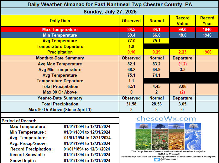
Most spots will see the start of Chester County’s 2nd “heat wave” of the summer season. Today through Wednesday should see highs topping out in the low 90’s each day. Today could be the exception across the higher ridge locales with highs a degree or two short of 90. A strong cold front will start to cross the area by later Wednesday night with shower and t-storm chances increasing and signal a nice change to below normal temperatures for next weekend. Below normal temperatures look likely for at least the first week of August.
-

E PA/NJ/DE Summer 2025 Obs/Discussion
ChescoWx replied to Hurricane Agnes's topic in Philadelphia Region
Most spots will see the start of Chester County’s 2nd “heat wave” of the summer season. Today through Wednesday should see highs topping out in the low 90’s each day. Today could be the exception across the higher ridge locales with highs a degree or two short of 90. A strong cold front will start to cross the area by later Wednesday night with shower and t-storm chances increasing and signal a nice change to below normal temperatures for next weekend. Below normal temperatures look likely for at least the first week of August.
-

July 2025 Obs/Disco ... possible historic month for heat
Hailstoned replied to Typhoon Tip's topic in New England
I’m in Des Moines- An extended elevated thunderstorm came through at 3:30 this morning with sporadic gale force wind gusts; looking at a pretty sizable branch down out the window. Tonight’s possible derecho may pass a little north? In the meantime another day of real heat; not unlike what’s on tap back home -

July 2025 Discussion-OBS - seasonable summer variability
SACRUS replied to wdrag's topic in New York City Metro
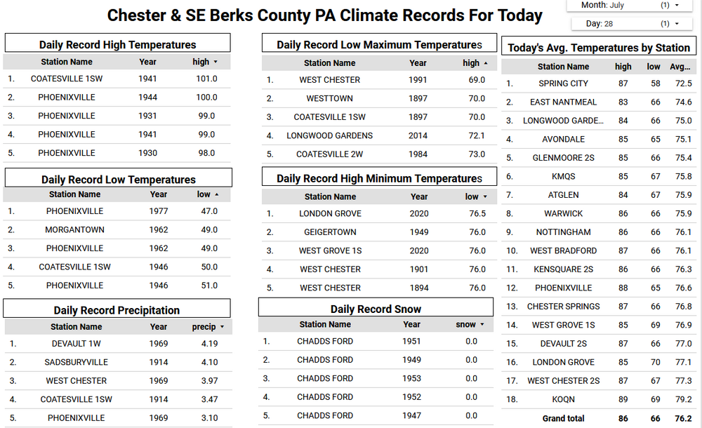
Records: Highs: EWR: 101 (1949) NYC: 97 (1999) LGA: 98 (1948) JFK: 98 (1949) Lows: EWR: 58 (1962) NYC: 55 (1920) LGA: 60 (1984) JFK: 57 (1977) Historical: 1609: The Sea Venture was crippled by a hurricane as it headed to Jamestown, VA with provisions for the starving colonists. The 150 men, women and children found safe shelter on the Bahama Islands, which the captain named Somers Islands after the ship's captain. Most of the colonists moved into Virginia the next year, but the island still celebrates Somers Day each July 28. (Ref. Wilson Wx. History) 1819: A small but intense hurricane passed over Bay Saint Louis, MS. The hurricane was considered the worst in fifty years. Few houses were left standing either at Bay Saint Louis or at Pass Christian, and much of the Mississippi coast was desolate following the storm. A U.S. cutter was lost along with its thirty-nine crew members. The storm struck the same area that was hit 150 years later by Hurricane Camille. (David Ludlum) (Ref. WxDoctor) 1819 - A small but intense hurricane passed over Bay Saint Louis, MS. The hurricane was considered the worst in fifty years. Few houses were left standing either at Bay Saint Louis or at Pass Christian, and much of the Mississippi coast was desolate following the storm. A U.S. cutter was lost along with its thirty-nine crew members. The storm struck the same area that was hit 150 years later by Hurricane Camille. (David Ludlum) 1898: A severe thunderstorm produced considerable hail (some stones to 11 ounces) in Chicago, Illinois business district. Some people were hurt, not by hail, but by several hundred runaway horses spooked by the hailstones. 1930 - The temperature at Greensburg, KY, soared to 114 degrees to set a state record. (The Weather Channel) 1934 - The temperature at Grofino, ID, climbed to 118 degrees to establish a record for Idaho. (The Weather Channel) 1935: Sheridan, WY recorded their all-time record high minimum temperature of 77°. The afternoon high of 106° was their second hottest temperature ever. (Ref. Wilson Wx. History) 1952 - A severe storm with hail up to an inch and a half in diameter broke windows, ruined roofs, and stripped trees of leaves near Benson, AZ. The temperature dropped to 37 degrees, as hail was three to four inches deep, with drifts 46 inches high. (The Weather Channel) 1952: The 99° temperature at Washington, DC set date record and month's mean of 80.9 gave 2nd warmest July. (Ref. Washington Weather Records - KDCA) 1974: Avon Park, Fla.--a 6-year old girl was killed by lightning while outside manually turning a TV-antenna pole for better reception. Fallsburg, NY - A mid-afternoon thunderstorm killed one golfer and injured another. Eastern Pennsylvania--One death and three injuries were reported to have resulted from lightning strikes. Hamilton County, Ohio--A boy was killed by lightning while walking from field to farmhouse. (Ref. Lightning-The Underrated Killer.pdf) 1976: A severe thunderstorm produced a tornado causing F3 damage in Madison County in Illinois The twister destroyed 11 homes, two churches, and a school in the western part of New Douglas and was responsible for 3 deaths and 30 injuries. (Ref. Wilson Wx. History) 1986 - Severe thunderstorms moving out of South Dakota across Iowa produce high winds which derailed eighteen piggyback trailer cars of a westbound freight train near Boone, IA. Sixteen of the cars fell 187 feet into the Des Moines River. The thunderstorms also spawned a number of tornadoes, including one which caused twenty-five to fifty million dollars damage at Sloan, near Sioux City, IA. (Storm Data) 1987 - Thunderstorms in Nevada produced wind gusts to 70 mph at Searchlight, reducing visibilities to near zero in blowing dust and sand. Thunderstorms in Montana drenched Lonesome Lake with 3.78 inches of rain. (The National Weather Summary) 1988 - Thunderstorms drenched Wilmington, NC, with 3.33 inches of rain, bringing their monthly total 14.46 inches. Seven cities in Michigan and Minnesota reported record high temperatures for the date. Marquette, MI, hit 99 degrees, and the record high of 94 degrees at Flint MI was their tenth of the month. (The National Weather Summary) 1989 - Afternoon thunderstorms produced large hail and damaging winds in Massachusetts. Early evening thunderstorms over Florida produced wind gusts to 68 mph at Fort Myers, and evening thunderstorms in South Dakota produced nearly two inches of rain in twenty minutes at Pierpoint. (The National Weather Summary) (Storm Data) 1995: A 15-year-old girl was struck and killed in Northampton County as she walked along Smith Beach, VA. Also on this day, in Danville, VA a woman was slightly injured by lightning while standing near a window in her house. (Ref. Lightning - Virginia Weather History) 1995: A heat wave prevailed across the southwestern U.S. Yuma, AZ reached its all-time high temperature reading with 124°. Palm Springs, CA hit 123° on this date and the 29th tying their all-time record high (7/10/1979 & 8/1/1993). It was 121° at Borrego Springs, CA, their highest temperature on record for July and their second highest temperature ever. Other record highs included: Riverside, CA: 107°, Idyllwild, CA: 95° and Big Bear Lake, CA: 90°. (Ref. Wilson Wx. History) 1997: Arlington, VA a man and woman were struck by lightning in the Pentagon's parking lot; the man was listed in serious condition. (Ref. Lightning - Virginia Weather History) 8 to 10 inches of rain fell across the Spring Creek basin near Fort Collins, CO during the evening hours. The water pooled behind a railroad track bed that acted as a dam, building the water level to a height of 20 feet. When the water began rushing over the top of the track bed, it quickly eroded the earthen embankment, and a wall of water 10 feet to 20 feet high rushed through two trailer parks in the city. 120 mobile homes and 19 houses were destroyed. Damage totaled $200 million dollars. The disaster hit just days before the 21st anniversary of the Big Thompson River flood, which killed 145 people about 20 miles southwest of Fort Collins. (Ref. Wilson Wx. History) In what was described by local residents as the worst flooding in 14 years, severe thunderstorms pounded Needles, CA with damaging winds and torrential rain. Rainfall estimates between 2 and 3 inches in less than one hour inundated and damaged part of a highway and made many local roads impassable. The strong wind gusts destroyed some car ports and downed numerous trees and power lines, further blocking traffic. No injuries were reported. 2000: 16 people were injured when Pam Am flight 165, a Boeing 727 traveling from Orlando, FL to Pittsburgh, PA encountered severe clear air turbulence. (Ref. Wilson Wx. History) 2001: Three young girls wading in knee deep water in the inlet between Rockaway and Atlantic Beach in Queens were swept away and drowned as dangerous rip currents funneled through the inlet. (Ref. Wilson Wx. History) 2004: Heavy rain produced flash flooding across western north Texas and south-central Oklahoma. Up to 8 inches of rain fell across Archer and Knox counties, with nearly 5 inches across Wichita and Clay counties. Runoff caused several rivers to spill their banks, including the South Wichita River, which eventually crested nearly 5 feet above flood stage near Benjamin, the 3rd highest crest on record for that site. Ardmore, OK received nearly 5 inches as well, along with flash flooding at the Chickasaw National Recreation Center. (Ref. Wilson Wx. History) 2011: 122-year rainfall record for July falls, more storms coming Two passing storms overnight dumped enough rain to make this July the wettest one in the city's history. They also knocked out power to tens of thousands of area residents and raised fears of more flooding. The wave of storms, which spurred tornado and flood watches across the area, raised this month's rainfall total to 9.75 inches, drowning the previous record of 9.56 inches set in July 1889. (July 28, 2011|By William Lee a Chicago Tribune reporter) -
July 2025 Obs/Disco ... possible historic month for heat
weatherwiz replied to Typhoon Tip's topic in New England
the SPC does mention derecho...nice -

July 2025 Obs/Disco ... possible historic month for heat
Damage In Tolland replied to Typhoon Tip's topic in New England
It will be NYC south . As usual -
Still think that’s a little too out there in terms of accuracy. The environment is marginally better, if that, but the background state is still pretty hostile.
-
July 2025 Discussion-OBS - seasonable summer variability
SACRUS replied to wdrag's topic in New York City Metro
Seems like a tendency for N?NNE flow a bit Mon/Tue kind of on /off on the models. -
I picked the right time to travel here lol
-
July 2025 Discussion-OBS - seasonable summer variability
SACRUS replied to wdrag's topic in New York City Metro
84 / 72 rising quickly. Heat is on the next 84 hours. Mid - upper 90s today, mid - upper 90s tomorrw (100 in the hot areas), same for Wed , pending on clouds. Thursday race to the front / storms and clouds but looks topped in the 80s. Storms and slow moving boundary could produce strong storms and local flooding where the line sets up between Thu AM and Fri PM. Behind the front a period of cooler - mainly onshore flow the first week of next month. Ridge rebuilds into the middle of the country and expands east - rising heights and a more southerly flow by the 8th transitioning to a warm-hot / humid period. 7/28 - 7/31 : Hot / Humid - Storms focused on Thu-Fri could be locally 2-4 inches 8/1 - 88 : Cooler - Onshore - drier overall 8/8 - beyond : Warm - Hot / Humid wetter overall -

July 2025 Obs/Disco ... possible historic month for heat
WxWatcher007 replied to Typhoon Tip's topic in New England
Environment doesn’t look conducive. AI is probably latching too much on climo and a marginally more favorable environment. Emphasis on marginally. I was just coming to post about it. Euro has been consistent with the setup. This we watch. 99.99% fantasy. AI is not yet competent imo in marginal environment tropical cyclone genesis. The regular ensembles barely have a signal if you can even call it that. -
July 2025 Obs/Disco ... possible historic month for heat
weatherwiz replied to Typhoon Tip's topic in New England
Is that some sort of very weak backdoor that rolls through tomorrow evening? Or maybe just a weakening front that probably lifts north a bit Wednesday as a warm front. -
What a look for early August.
.thumb.png.3ec09e2be5118b439842018576cebf60.png)
-

July 2025 Obs/Disco ... possible historic month for heat
Torch Tiger replied to Typhoon Tip's topic in New England
Board burnout seems cocky and confident on 7" -
July 2025 Obs/Disco ... possible historic month for heat
weatherwiz replied to Typhoon Tip's topic in New England
I'd have very low confidence in the end of the week. How all this convective potential evolves from the upper-Midwest/Great Lakes/Ohio Valley is going to play a significant factor in how this evolves for us.


.png.7c450a5d8cab405c01df622dfd50fccb.png)