All Activity
- Past hour
-
I haven’t seen changing opinions on this. Changing model scenarios, sure.
-
He does like to sugarcoat lol
-
I would expect a well respected met to update their forecast base on the latest data
-
I’d expect the pattern to relax at some point and I wouldn’t be surprised if you’re correct about Christmas. I do think we end up in the freezer again by mid-Jan….just a hunch based on another possible period of SSW.
-

December 2025 regional war/obs/disco thread
Damage In Tolland replied to Torch Tiger's topic in New England
Fight , fight , fight -
Poo poo
-

December 2025 regional war/obs/disco thread
Ginx snewx replied to Torch Tiger's topic in New England
You know skewts use closest data points not exact location right -
December 2010 comes to mind- it was a La Nina and we had that phase on Christmas and model wars for days before. It was a special time. Lots of northern stream energy flying around the next few weeks, can we get a phase with some southern energy?
-
December 2025 regional war/obs/disco thread
Ginx snewx replied to Torch Tiger's topic in New England
Tough when we change our opinions every 6 hours ha -

December 2025 regional war/obs/disco thread
Snowcrazed71 replied to Torch Tiger's topic in New England
Lolol.. You are so passive aggressive. It's too funny. I think we'll have a lot of chances throughout December. If this doesn't pan out, okay then we move to the next one. Come at least for Southern New England. But are we out of it, absolutely not -
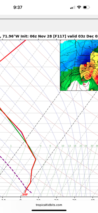
The euro soundings available from vendors don’t have the vertical resolution that you get from something like gfs/nam/hrrr. It’s probably because of how much data is available, but we’ve talked about that on here. I never look at them. Vendors may try to smooth them out but I’m almost positive that is the case. Also, is that your exact location? Because that is zoomed out and looks like it’s N and W of your location.
-
forecasts are opinions if everyone's opinion was the same, this forum wouldn't be worth reading
-

Nov 28-30th Post Turkey Day Wintry Potential
Brian D replied to Chicago Storm's topic in Lakes/Ohio Valley
Glad to see some good snowstorm action for you guys down there early in the season. Usually it's us N guys that see all the action this time of year, except for some LES events. -
December 2025 regional war/obs/disco thread
Ginx snewx replied to Torch Tiger's topic in New England
Please show us why you say the vertical resolution on skewts published by professional forecasters is wrong. You can't just say that without proof. -

December 2025 regional war/obs/disco thread
weatherwiz replied to Torch Tiger's topic in New England
One big difference too between this year (at this time) compared to the last several years is water temperatures off the coast aren't as warm. Maybe not a huge deal now, but if we keep getting these pushes of colder air, this could be something to help drive the baroclinic zone a bit farther south and east than we've seen lately. Maybe instead of seeing lows go bonkers inland in the southeast or mid-Atlantic that happens farther east either along or just off the coast. -
It looks like GEFS is trying to loop back into 7/8 after its u-turn into 6. Hovmollers shows this as well.
-

2025-2026 ENSO
donsutherland1 replied to 40/70 Benchmark's topic in Weather Forecasting and Discussion
Yesterday, I noted that the GEFS was trying to push an EPO+, but its forecast 500 mb pattern was profoundly different from any of the December WPO-/EPO+/AO-/PNA- clusters. That suggested that either the teleconnection idea was off or the pattern was off, rather than some novel outcome. Overnight and through today's 6z cycle, the GEFS has continued to evolve. It has added a WPO+ to its EPO+ idea and restored its earlier idea of a AO+. It has now joined the Canadian ensembles that keep the MJO out of Phase 8 through its forecast horizon. In short, its previously significant areas of "disconnect" have disappeared overnight. Its forecast pattern is now more consistent with what one would expect. For now, the GEFS is trying to build a credible milder alternative scenario for the pattern/temperature evolution in North America toward mid-December. The EPS has not shifted toward that emerging GEFS idea. Therefore, the baseline idea remains that the northern tier of the U.S. and most of Canada should remain cold toward and probably beyond mid-December. The Southeast could still turn warm despite some shots of colder air. Mid-December and beyond is still in the low-skill distant realm. The big story through the weekend will be the significant snowstorm that will affect parts of the Midwest and Great Lakes Region. As a result, Chicago, Detroit, Milwaukee, and Toronto remain on track to experience their snowiest fall in five or more years. As an appetizer, Detroit added 0.1" snowfall yesterday and Toronto picked up 1.2 cm (0.5") yesterday. -
I’m still worried we’re gonna have a cool start to December with some occasional chilly rains and then have a toasty Christmas time period.
-
 Based on ensemble guidance seen through 06z/28, a rapidly intensifying and fast moving coastal low will bring a variety of weather elements to the NYC subforum. Periods of moderate to heavy rain are expected coastal areas- preceded by a little snow-sleet near dawn Tuesday and to closeout the storm Tuesday evening, while a period of heavy snow-sleet seems likely for the interior, especially the I84 corridor. Gusty northerly winds to 45 MPH are possible for eastern Long Island in the early Wednesday morning departure. Due to the late development and rapid departure of the storm, the chance of coastal flooding is minimal. All ensembles including ECAI have significant precipitation. This may be Central Parks first measurable snow-sleet of the season, though temps at or just above freezing at sunrise Tuesday may preclude onset measurable in the city. Delays are anticipated over the interior hilly terrain with possible school closings or early dismissals along and north of I80, especially the I84 corridor from the Poconos across se NYS into CT. One attached graphic (WSSI-P) shows the potential for a minor impact event per the NWS inputs for the their 1AM Friday forecast.
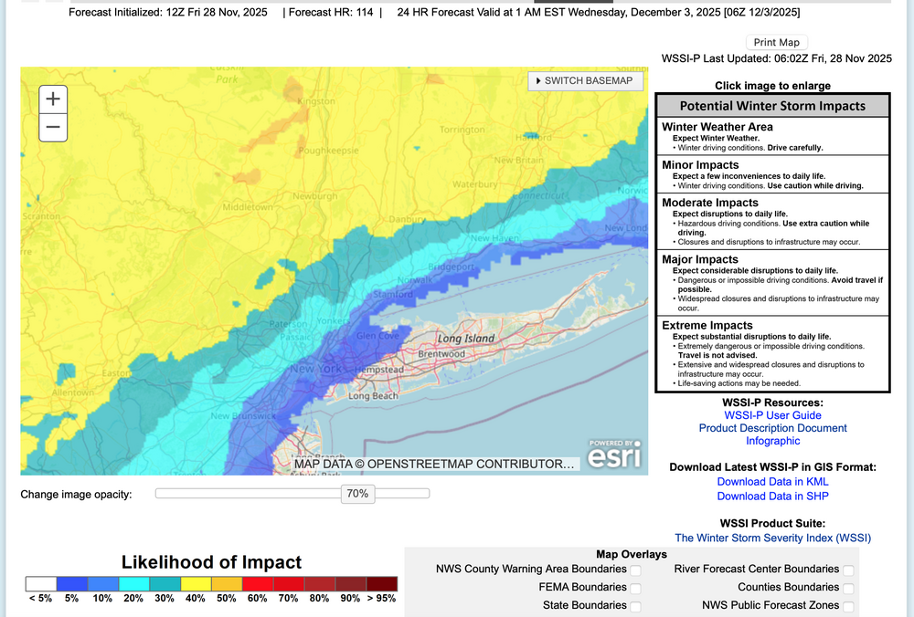
-
December 2025 regional war/obs/disco thread
Ginx snewx replied to Torch Tiger's topic in New England
Very active month. Some hits Some not. All we can ask for is the chances. Temps are there hopefully the tracks are good. Peeps should know their climo. Anything more than 4 inches here the next 15 days is a bonus -
I’ve stated it multiple times. It’s mild in the boundary layer even as of now for you. Maybe you start as some paste, and end as snow, but that’s a tough look even for you. Latitude hurts. It’s not being a debbie, it’s putting on a forecaster hat and looking at reality. Maybe it goes back to the 12z run yesterday and changes things.
-
Early December can work like 2018/2017 but we need that cold entrenched or strong CAD which im just not seing.
-
Why can’t you be happy for the north?
-
December 2025 regional war/obs/disco thread
Ginx snewx replied to Torch Tiger's topic in New England
See show us the deets. Back your statement up is all ask not some weak sardonic Masshole remark -
Snow showers around here. Yesterday aftrn had a couple snow squalls that reduced vis to 1/4 mile or less really fast. They were brief. Nice to have some wx action for a change these past few days.


