All Activity
- Past hour
-
Who needs snow when the demise of society is imminent-
-

Occasional Thoughts on Climate Change
Typhoon Tip replied to donsutherland1's topic in Climate Change
Okay, I was responding to that post - within which you did not specify "this country" I wasn't aware if there's any back ground context preceding - Having said that... I agree in so much that people don't notice what does not cause them inconvenience more directly than it has. The fact that that there are examples of this abroad should cause the same pause anyway ... but that's perhaps a different discussion. -

Pittsburgh PA Fall 2025 Thread
TheClimateChanger replied to TheClimateChanger's topic in Upstate New York/Pennsylvania
-
You said a lot but very little related to my point. I said there haven't been MAJOR impacts to agriculture or large numbers of people losing their homes by the ocean. Meaning in this country. Neither has occurred. By major, I mean massive price spikes (not inflation-driven) or shortages of food due to climate change. Things people would really notice and care about. That has not occurred. And thus there is not the widespread public outrage for change.
-
Yes, totally. We kind of "acknowledged" each other when you moved up here a few years ago. I have lived here downtown since 2010, from Boston and Newton, Mass., born and raised, but have lived in a couple other cities over the years. I don't usually post much, just OBS during winter, but have a little time off from work while I take care of moving, birthday last month, busy stuff that I don't have time to do while working (thanks, Boss! :)). Anytime--coffee, BEER (ha), lemonade, whatever. Edit, forgot emoji.
-
It's a dumbing down of population, one that then became subjected to enormous data and "unconstrained interpretation" ( last 20 years...). They were first made less incapable of categorical management ( mentally...), then it looks unmanageable to them in what's really become sociological crisis in society. All dimensions. Decision making and judgements failing to screen through very good, if at all, objective analytics, is actually causing frenetic disruption, paranoia, good old fashioned fear. It's why "populism" is making a comeback. Populism gives rise to dictatorships - or prone to that occurrence throughout history, by the way. It's not just America either. It's what technology is doing to humanity in a great evolutionary experiment our species has embarked upon. It started with the Industrial Revolution, and has really gotten uncontrolled - particularly spanning the last 30 years of technology acceleration. Folks may not be able to articulate and/or quantify in sophistication/understanding, but damn well can intuit and abstractly sense .. But this latter form of awareness lends to uncertainty. Uncertainty = fear at group capacity. --> contractions and pull away from progressive ideologies, seeking "safe traditions" - which unfortunately ... are on the wrong side of history, because those same traditions also got us into a state of climate crisis... It's not gonna end well, folks.
-

Spooky Season (October Disco Thread)
Prismshine Productions replied to Prismshine Productions's topic in New England
Holy shit we should meet up around town at some point, plenty of places here in Brattleboro for that Sent from my SM-S166V using Tapatalk -

Spooky Season (October Disco Thread)
weatherwiz replied to Prismshine Productions's topic in New England
Wow, I had no clue EWALL made major upgrades! https://mapwall.met.psu.edu/ewall/ -
Hybrid
-
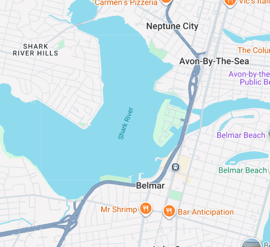
It depends on where their forecast area is based off the green box on the map, it says it right on the page, so whatever Don points out is actually told right there. Belmar includes the Shark River area, whereas south Belmar is several miles away, so that is why it is probably cooler by being mostly surrounded by water vs not. Anyway, enjoy seaside. Rides and games should be open for fun. Years ago in the late 80s/early 90s when I was a kid, the one wheel game where you could win baseball cards, I figured out the wheel clicks and would win like 80% of the time, haha.
-
Had a low temp of 47 here this morning. We have the 4 day blast of summer with highs in the low to mid 80s Saturday through Tuesday, and then I'm hoping we get some heavy downpours with the front on Wednesday like last night's Euro showed. Then a nice cooldown for late week with high temps in the 60s.
-
Don pointed out the strange discrepancy in the NWS forecast for down there, as they have 72 for Belmar but 77 for South Belmar. It doesn't make any sense. It definitely will be much warmer than 72 at Belmar this weekend since the wind will be switching to the southwest. I'm going down to Seaside Heights on Saturday and I'll be surprised if it isn't in the upper 70s.
-
Spooky Season (October Disco Thread)
Typhoon Tip replied to Prismshine Productions's topic in New England
I play this game every year. I try for October 15; not sure what my success vs failure in winning that date is on average. I've had years where I could not make it ... like it was 48 in the place some dawn, with frost out there on the lawn, and yeah, the forecast was 64 for high but mmm. The house has a 'cold memory' when the sun's not exactly heating the house this late in the year. One year ..I think it was 2009, my in-laws had ripening tomatoes and new yellow flowers on Thanks Giving as we toured their huge garden in cargo shorts weather. I think I made it to early Dec that year ... It was 57 in here this morning. I could have given the place a puff of heat but it feels weird to do that when it's going to be 80 from Saturday to next Wednesday ... -

2025 Atlantic Hurricane Season
WxWatcher007 replied to BarryStantonGBP's topic in Tropical Headquarters
Took a minute to pull together, but here's my latest analysis. We're far from done. -
We've made it to October, and with Imelda in its final act and just under three weeks left in the peak season forecast, it's time to take a look at what comes next. Peak Season Forecast (Aug 20-Oct 20) Named Storms: 10 (4) Hurricanes: 6 (3) Major Hurricanes: 3 (2) Fernand, Gabrielle (MH), Humberto (MH), Imelda (H) First, there's still plenty of potential left in the basin. Although climo is quickly shifting westward, we still see robust AEWs moving into the basin, and one of those will actually be an area of interest discussed below. Yes, there is dry air/SAL in the tropical Atlantic, but look at the ITCZ and the convection we have there. This will go a long way toward ensuring the survival of the coming waves. A key part of what happens the rest of the period will center around intraseasonal forcing. Will the MJO remain in a favorable state for TC genesis and landfall risk? Will we get a CCKW that enhances the opportunity for waves to develop? The signals are mixed, but I think we will remain in a favorable period overall through the end of October. As I stated in my peak season forecast, I still think we rapidly end the season at the end of the month however. In terms of getting more NS and H, the basin continues to be primed for it, with SST anomalies still robust throughout the Atlantic. As we shift toward activity in the climo favored spots off the SE coast, Gulf, and Caribbean--especially the western Caribbean, there is plenty of fuel for low to moderate end activity. The picture becomes more complicated when looking at high end activity, however. To be sure, there is plenty of OHC, especially in the western part of the basin. But a deeper look shows that there are more localized regions where higher end activity is more likely. I don't think this changes much, but we definitely have to watch out for another potential MH if it gets into these zones of anomalously high OHC. Finally, we have been extremely lucky that nothing has formed in the Caribbean. Between anomalously high OHC and exceptionally low shear, we've been avoiding disaster--seriously. Now that climo is shifting into this region, we need to closely monitor 1) the development of a CAG by mid-October and 2) any tropical waves getting to the Caribbean. There is a strong signal for anomalously low wind shear to return--though this year has been incredibly conducive in the wind shear category. Alright, so what are we watching? I have three areas of interest. 1. Tropical Atlantic Wave The Tropical Atlantic has been more of a bust this season as expected, in large part due to the prevalence of dry and stable air along with SAL. This has been an issue throughout the decade. However, those conditions are more limited now, and an active wave train has moistened a good part of the MDR. There is a strong cross guidance signal that a wave emerges and finds hospitable conditions in the ITCZ. This should eventually lead to some level of development, as evidenced by the models. I am bullish on development. 2. SE Coast/Gulf This is the second lemon by the NHC, and it's no surprise given that there has been a signal for a few days now. In the wake of Imelda, we have a boundary that is left behind, and along it we have some vorticity trying to spin up. Now, whether that becomes a low is unclear, but we do know that climo starts to favor these kinds of things in October. The limiting factors are proximity to land, and time. Whatever develops should cross Florida and into the Gulf, but is unlikely to meander there with time to develop into anything serious. This probably has a decent chance of development, though not nearly as high as area #1. It's worth a casual eye. 3. Caribbean CAG This is the one to watch, even though there isn't a significant development signal, yet. Toward the middle of the month, guidance is starting to show the development of a Central American Gyre, which favors slow, but gradual tropical genesis. The CPC has picked up on it, and recent years have shattered the mold on what CAGs can become. Recently, they've become some of our most destructive storms. With wind shear expected to drop significantly and the thermal environment in the Caribbean, along with the increased tendency for troughing in the east around this time, our next significant threat may very well come from this region.
- Today
-
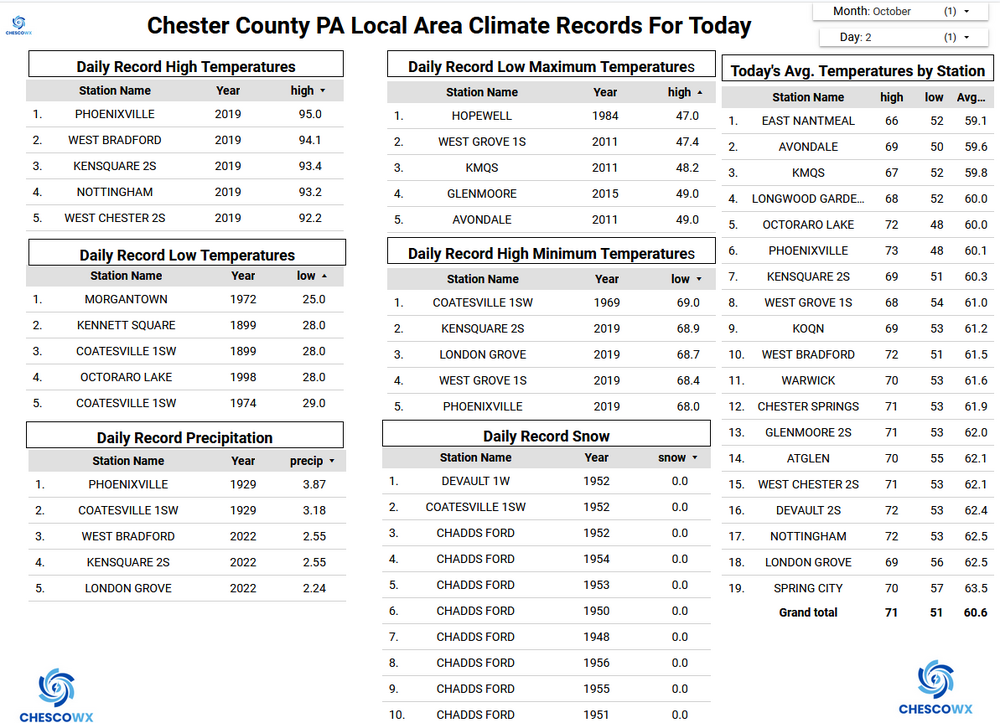
(002).thumb.png.6e3d9d46bca5fe41aab7a74871dd8af8.png)
Central PA Fall Discussions and Obs
ChescoWx replied to ChescoWx's topic in Upstate New York/Pennsylvania
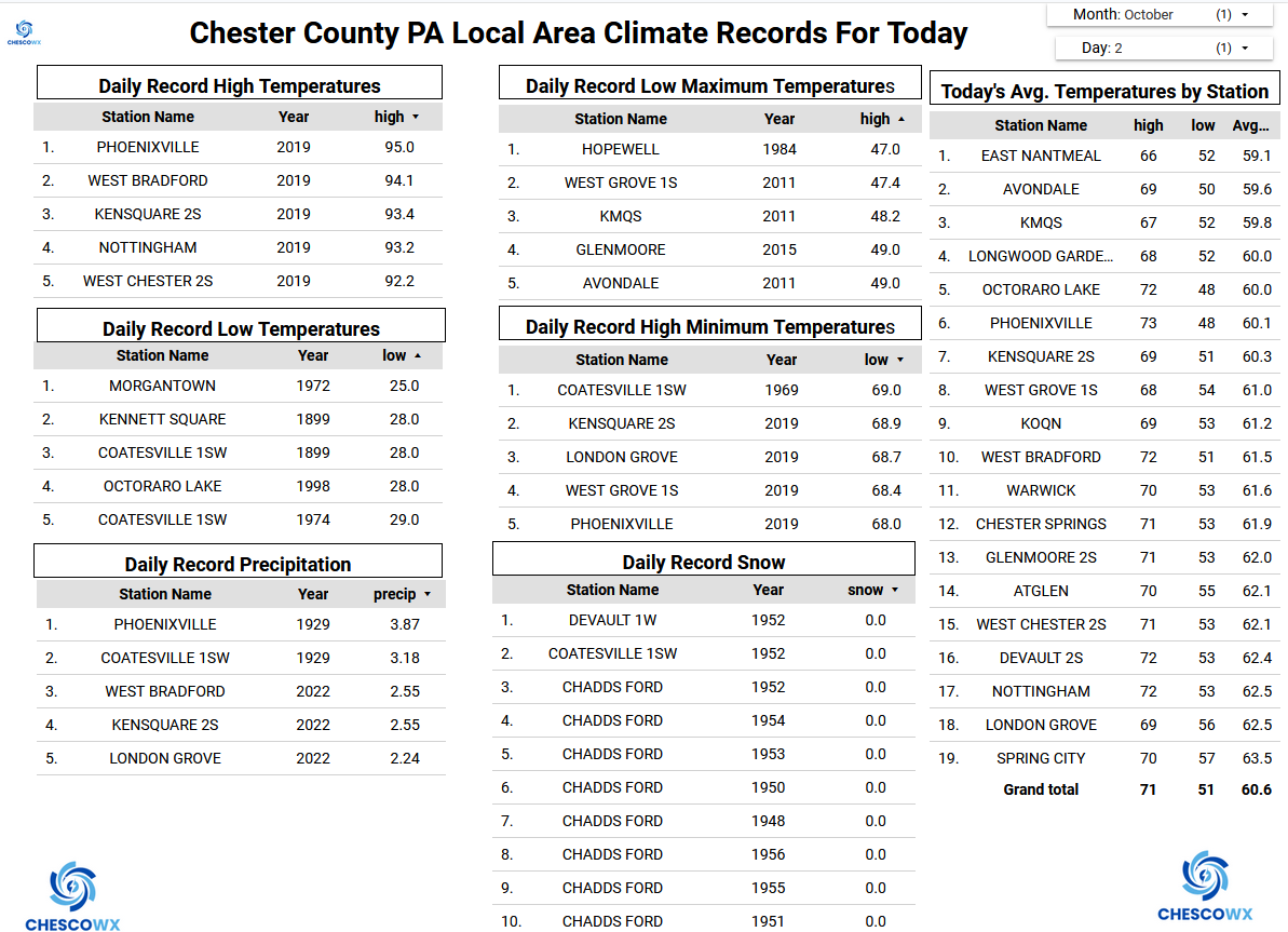
Some of our colder valley locations saw lows this morning in the chilly 30's. The lowest was at Warwick Township at 37.4 degrees. The next couple of days will be seasonably cool with highs not too far from normal in the upper 60's but lows a bit below normal including some of those same spots tonight sinking into the 30's. We start a moderating trend starting Saturday that should last through the middle of next week before we turn much cooler again toward the end of next week. Our best rain chances look to be next Tuesday or Wednesday.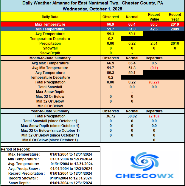
-
E PA/NJ/DE Autumn 2025 Obs/Discussion
ChescoWx replied to PhiEaglesfan712's topic in Philadelphia Region
Some of our colder valley locations saw lows this morning in the chilly 30's. The lowest was at Warwick Township at 37.4 degrees. The next couple of days will be seasonably cool with highs not too far from normal in the upper 60's but lows a bit below normal including some of those same spots tonight sinking into the 30's. We start a moderating trend starting Saturday that should last through the middle of next week before we turn much cooler again toward the end of next week. Our best rain chances look to be next Tuesday or Wednesday.
-
Yeah, it was nice. But the 55+ warmup occurred right on schedule just before on the 17th and 18th. Then mid 60s warmth to close out the month. Sum 1396 953 - - 833 0 4.39 3.5 2024-12-17 61 46 53.5 15.9 11 0 0.02 0.0 0 2024-12-18 55 39 47.0 9.6 18 0 0.23 0.0 0 2024-12-19 47 36 41.5 4.4 23 0 0.04 0.0 0 2024-12-20 39 33 36.0 -0.9 29 0 0.05 0.3 0 2024-12-21 33 20 26.5 -10.1 38 0 0.08 2.2 2 2024-12-22 23 13 18.0 -18.4 47 0 0.00 0.0 1 2024-12-23 29 11 20.0 -16.2 45 0 0.00 0.0 1 2024-12-24 41 26 33.5 -2.4 31 0 0.07 1.0 T 2024-12-25 36 27 31.5 -4.2 33 0 0.00 0.0 T 2024-12-26 39 22 30.5 -5.0 34 0 0.00 0.0 0 2024-12-27 44 22 33.0 -2.3 32 0 0.00 0.0 0 2024-12-28 48 38 43.0 7.9 22 0 0.71 0.0 0 2024-12-29 65 46 55.5 20.6 9 0 0.19 0.0 0 2024-12-30 59 44 51.5 16.8 13 0 0.21 0.0 0 2024-12-31 54 38 46.0 11.5 19 0 0.71 0.0 0
-

Spooky Season (October Disco Thread)
Ginx snewx replied to Prismshine Productions's topic in New England
Love it. Keep it up for the next 3 weeks. Cool shots end of month. Pattern change begins the 15th complete by the 21st -
Spooky Season (October Disco Thread)
Ginx snewx replied to Prismshine Productions's topic in New England
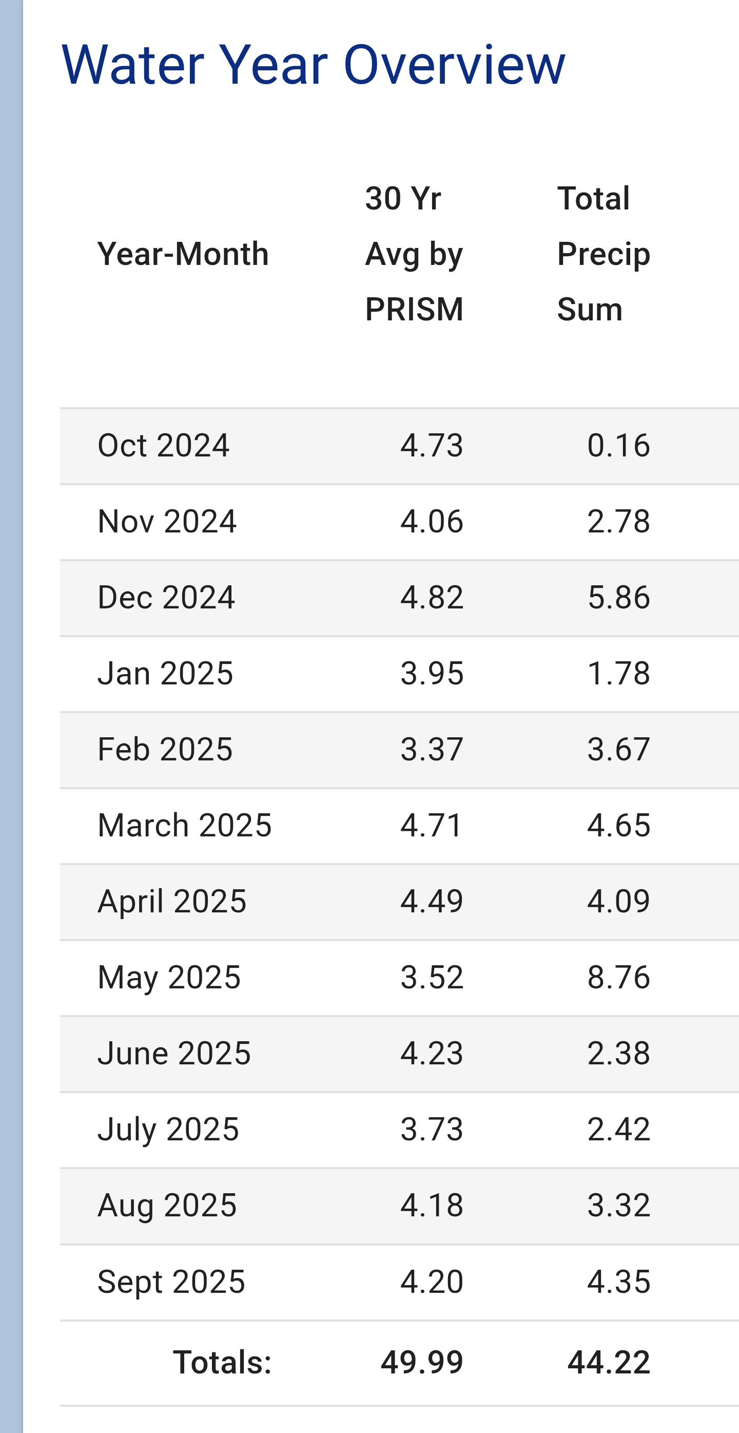
5 inches under for the 2025 water year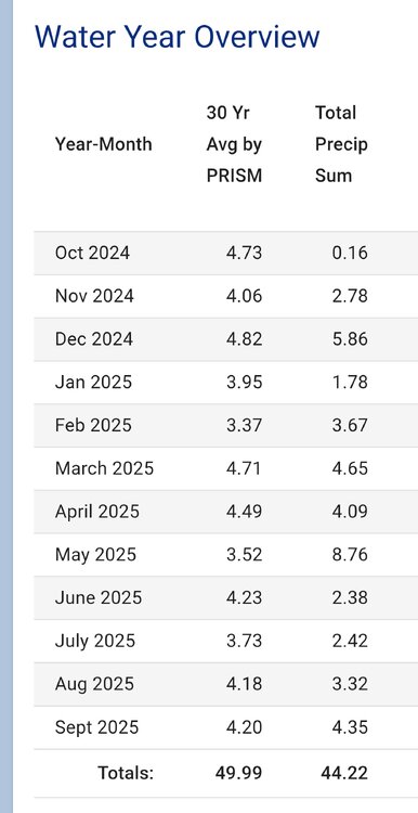
-
Good for winter
-
Overnight low here of 45. Perfect. Windows open until just before daybreak. Walpack bottomed out at 31 with lots of l/m 40's over northern and central NJ. The coming warmup will truly suck after these nice crisp few days. At least some rainfall on the horizon in about a week.
-
Are the corn fields harvested? If not, looks like dried out corn that's ready to be. Regardless, it has been dry your way.
-
That’s why the average home price there is $15 million lol
-
That leads to cold air pooling. My old house was in a low spot in town and cooled very well. New spot on the hill not as great. Compared to my old spot in the lower area it’s about 2 degrees warmer on RC nights