All Activity
- Past hour
-

January 2026 regional war/obs/disco thread
doug1991 replied to Baroclinic Zone's topic in New England
What kind of service do you do? -
Not a bad trend for that diving piece. Though I could not get 18z since it does not go far enough. In the interest of transparency, I think the organization of the whole thing was worse there. But 00z and 06z definitely nice trends away from that.
-
Baby steps.
-
I thought the ICON was loading up too at the end of 6z, but what do I know.
-
And keep ticking that all west. “Classic” east coast storms have the H5 trough go neutrally tilted near the MS river and negative around the time it hits the Apps. We’ve definitely moved in the right direction in that regard, but the reason OTS solutions still occur (aside from phasing challenges) is the trough is too positively tilted.
-
Being in my 50s, I am blessed to have 2 teenagers that keep me young and 'in the loop'. Last legit storm we got Dec 13-14 here they asked me how much I was looking at. I said 6, maybe 7 and they did some juggling motion and started repeating six, sevennnn. So, um, yeah I 'blessed'
-

January 2026 regional war/obs/disco thread
UnitedWx replied to Baroclinic Zone's topic in New England
Clouds and raw as f**k in Simsbury, 29 degrees. Great morning for an outdoor service call -

January 2026 regional war/obs/disco thread
moneypitmike replied to Baroclinic Zone's topic in New England
Sun and blue sky here in PVD -
Yeah probably not us and more north east but that new diving feature still has a ways to go in terms of resolution, if it sticks around. Definitely could up the ante if it interacts positively.
-
I did have the two towns transposed in my head. 29 in E.W. and 31 in Simsbury.. well, West Simsbury really
-
Lies. It's not "constant" as the 5-year old image in the post claims, both the frequency and intensity have been increasing, and the rate of change is accelerating. I imagine if you aren't being personally affected, it's easier to internally justify "nothing to see here" hot take this pretty clearly indicates you have a political agenda, and because of that, your postings on this topic can be summarily dismissed
-
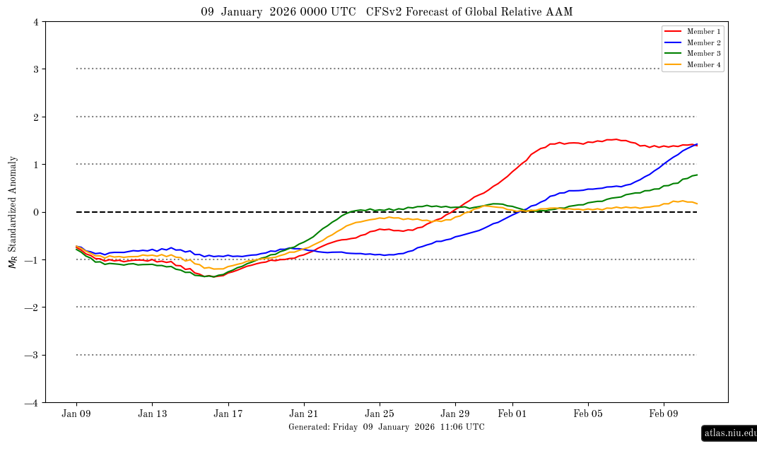
Latest CFS AAM forecast: pretty close to prior one suggesting rise to modestly + in early Feb:
-
Someone would get hit pretty decent if it the Euro ran a little longer.
-
I like the trend of a stronger, sharper ridge out west. This gets said all the time but it’s real here: there is a ton of energy flying around late next week. We need to continue the trend of a sharper trough, more dig for a phase for storm 1. Storm 2 is tough to talk about bc it seems so reliant on what happens with storm 1. I’ll take the players on the board right now. EURO and GFS both have big dog potential if everything falls right and honestly we haven’t seen that in years. Late bloomer seems most likely path to victory with storm 1 but if that trough goes negative tilt just a little earlier and that low gets tucked this storm could really go to town. Keep building heights out west and dig the trough a little deeper and I think you’ll keep seeing some fantasy runs pop up
-
Looking over that 6z run of euro that northern piece of energy diving in and phasing would be amazing if times up right. Hope trend continues on 12z and it dives in to meet the southern piece of energy and phases and turns the corner.

-
January 2026 regional war/obs/disco thread
moneypitmike replied to Baroclinic Zone's topic in New England
When someone offers you 10,000 to 1 odds on ANYTHING, you take it. -

January 2026 regional war/obs/disco thread
Typhoon Tip replied to Baroclinic Zone's topic in New England
GFS' recent runs hinting at that ... My only point before is that there's wave interference that is negative. That trough totality, albeit containing some potent embedded S/W at beta scales, is in fact positively tilted. The QUE vortex up there is in bad spot climo and physics-wise. These aren't really disputable. But he brought up a good point about looping and seeing the history, and the wind barbs are turning more S along and off-shore, so that's indicative of slowing - or having the ability to do so - the progressive nature overall. The WI dive probably catches, and then the phase ends up potency has enough - your "hook and latter" low fits that. But ... shit this can all change of course. it's fun to jockey the model runs LOL -

January 2026 regional war/obs/disco thread
jbenedet replied to Baroclinic Zone's topic in New England
Good point. To be sure I’m thinking most commonly 43-45 readings, for the region. a solid +10 today Dews will also be rising all day so it will compound the real feel. Legit warmth on this merit as well… Gotta get outside… -
January 2026 regional war/obs/disco thread
Typhoon Tip replied to Baroclinic Zone's topic in New England
yeah, no question there. you know there's a chance we could mix some. the NAM's grid has mid BL winds over 20 kts from the SW at 18z. might just get it done -
Oh I like that graph.
-

January 2026 regional war/obs/disco thread
CoastalWx replied to Baroclinic Zone's topic in New England
Yeah I’m not greedy. Just something other than 1-3” of fluff. Feb 16 did that here. Was paste for awhile and finally dropped below 30 second half. Even had some tree damage in that. 6z gfs was similar to what you said. Mixed here going to snow. Temp drops on NE winds like the days of yore. -
January 2026 regional war/obs/disco thread
moneypitmike replied to Baroclinic Zone's topic in New England
No doubt, bare ground is in store for SNE. Different story for CNE and NNE as they have more snow and it will remain both cooler and snowier. As one would expect. 33 already in PVD vs. 27 at Pit2. Off to rake more leaves. -
That is a horrific map. Not sure what they were looking. Usually the NESIS maps are good for looking at the general idea of the snow distribution despite being too conservative, but this map is completely wrong and way too aggressive with the snow in SNE and NJ/NYC
-

2025-2026 ENSO
40/70 Benchmark replied to 40/70 Benchmark's topic in Weather Forecasting and Discussion
@michsnowfreak -

January 2026 regional war/obs/disco thread
dryslot replied to Baroclinic Zone's topic in New England
Was colder then the county this morning here. 782 ASUS41 KGYX 091110 RWRGYX WEATHER ROUNDUP FOR MAINE AND NEW HAMPSHIRE NATIONAL WEATHER SERVICE GRAY ME 600 AM EST FRI JAN 09 2026 * THESE REPORTS ARE NOT UNDER NWS QUALITY CONTROL AND/OR DO NOT REPORT WEATHER SUCH AS PRECIPITATION AND FOG. MEZ002-005-006-010-012-015-018-020-021-024-026-027-029-091200- MAINE CITY SKY/WX TMP DP RH WIND PRES REMARKS PORTLAND CLEAR 20 19 96 CALM 30.33S SANFORD* CLEAR 14 11 87 CALM 30.31F BAR HARBOR CLEAR 23 21 92 CALM 30.36R WISCASSET CLEAR 19 15 84 CALM 30.34F ROCKLAND* CLEAR 20 19 96 CALM N/A FRYEBURG CLOUDY 11 7 84 CALM 30.30F LEWISTONAUBURN CLEAR 14 12 92 CALM 30.32S AUGUSTA CLEAR 22 19 89 SE3 30.31F WATERVILLE* CLEAR 18 16 93 CALM 30.29F FOG BANGOR CLEAR 17 16 95 CALM 30.34R GREENVILLE N/A 26 25 96 SE5 30.21R MILLINOCKET CLOUDY 30 25 81 CALM 30.30S HOULTON CLOUDY 29 25 85 CALM 30.26F PRESQUE ISLE CLOUDY 29 26 89 S6 30.26F FRENCHVILLE CLOUDY 27 24 89 S7 30.20S CARIBOU CLOUDY 28 25 88 SW5 30.24S $$