All Activity
- Past hour
-
By the look of the pattern there’s probably a better shot of the Pats going 17-0 than a direct hit. Probably can’t even rule out a track that is into FL or SE coast depending on exactly if/where a center pops
-
That will be 300mi out to sea by Monday's Euro runs.
-

Eastern Tropical Atlantic Wave - 0/40
GaWx replied to BarryStantonGBP's topic in Tropical Headquarters
The 6Z GEFS is similar to prior runs. Though it’s still very early, the overall consensus in the last few runs of models/ensembles seems to me to be suggesting a better chance of a safe recurve from the Conus vs a hit with the Gulf having an even lower threat than the E coast. The faster the development in the E ATL, the lower the US hit chance I believe, especially with a relatively high latitude MDR track progged by the models. If OTOH development is slow the next few days, that could portend at least a higher E coast hit chance. -
Yeah, I think we should begin evacuations now. Ecacuate where? Who cares?! Just evaciate!
-
Op way west of ens. Its fishing
-
41° at MVY this morning

-
 Another 50's August morning.
 -
Yeah I guess for a weak nor'easter, good spot
-
Unfortunately euro ai and gfs most likely scenarios, but weenies can always pray.
-
 This isn't surprising when one makes an "Apples-to-Apples" comparison. Philadelphia's heat island is relatively mature. So one sees a relatively constant UHI effect (I illustrated it below on the graph you created) amidst the year-to-year variability and a similar longer-term trend in temperatures. Most or virtually all of the recent warming is from climate change, as one would expect when a heat island is mature. Reading is likely exhibiting a faster warming trend, as it has seen very rapid population growth (proxy for an expanding heat island that is amplifying its warming trend) since 2000 (population +350% 2000-24) relative to Philadelphia, which has seen a 3.7% increase in population over that same period.
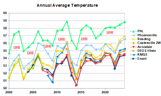
-
Now this is a beautiful morning. The sky is clear of smoke, humidity, and clouds. That's been rare this summer. Low of 58 here in the lowlands. Almost jacket weather.
-
Effing things are coming down again.
-
It would fix your acorn problem.
-
And no power for two weeks. If/when we do get hit it will be funny to listen to people bitching about power being out for 24hrs never mind a week+!
-
Glad we here
-
Eastern Tropical Atlantic Wave - 0/40
GaWx replied to BarryStantonGBP's topic in Tropical Headquarters
0Z UK had it again and it’s stronger (TS) though it’s further N:NEW TROPICAL CYCLONE FORECAST TO DEVELOP AFTER 132 HOURSFORECAST POSITION AT T+132 : 22.0N 54.6WLEAD CENTRAL MAXIMUM WINDVERIFYING TIME TIME POSITION PRESSURE (MB) SPEED (KNOTS)-------------- ---- -------- ------------- -------------1200UTC 14.08.2025 132 22.0N 54.6W 1010 300000UTC 15.08.2025 144 23.3N 57.2W 1009 301200UTC 15.08.2025 156 25.5N 59.1W 1007 410000UTC 16.08.2025 168 26.8N 61.6W 1006 44 -
Looks like gfs
-
Not that far. I'd like to see that one. Everyone getting their panties and a bunch and then wide right.
-
Euro AI far and away OTS
-
Still too far east for most of us
-
I know the low is over the cape, but I’ll take 8-10” of rain and 70mph winds.
-
After this, I got several more rounds of rain through the evening of 7/8 adding to that gotten yesterday afternoon adding up to a total of ~1.3”. After emptying that, I then through the early morning hours (7/9) received heavy showers coming off the ocean with the heaviest 5-5:30AM. I estimate 2” from the late night through now (7:40AM) with light rain still falling. All of this is on top of the 6” I got Aug 1-6! So, I’m at ~9.3” Aug 1 through 7:40AM of Aug 9!My water table is ridiculously high. Fortunately though due to the rains being spread out enough, I’ve yet to have any garage flooding this month despite heavy puddling of rain sitting just outside the garage. However, more heavy rains are possible over the next few days.Not one but two flash flood warnings were up for the county since late afternoon yesterday (8/8)!#1:BULLETIN - EAS ACTIVATION REQUESTED FLASH FLOOD WARNING NATIONAL WEATHER SERVICE CHARLESTON SC 353 PM EDT FRI AUG 8 2025 THE NATIONAL WEATHER SERVICE IN CHARLESTON HAS ISSUED A * FLASH FLOOD WARNING FOR... CHATHAM COUNTY IN SOUTHEASTERN GEORGIA... * UNTIL 700 PM EDT. * AT 353 PM EDT, DOPPLER RADAR INDICATED THUNDERSTORMS PRODUCING HEAVY RAIN ACROSS THE WARNED AREA. BETWEEN 1.5 AND 2.5 INCHES OF RAIN HAVE FALLEN. ADDITIONAL RAINFALL AMOUNTS OF 1 TO 2 INCHES ARE POSSIBLE IN THE WARNED AREA. FLASH FLOODING IS ONGOING OR EXPECTED TO BEGIN SHORTLY. HAZARD...FLASH FLOODING CAUSED BY THUNDERSTORMS. SOURCE...RADAR INDICATED. IMPACT...FLASH FLOODING OF SMALL CREEKS AND STREAMS, URBAN AREAS, HIGHWAYS, STREETS AND UNDERPASSES AS WELL AS OTHER POOR DRAINAGE AND LOW-LYING AREAS. * SOME LOCATIONS THAT WILL EXPERIENCE FLASH FLOODING INCLUDE... POOLER, DOWNTOWN SAVANNAH, HUTCHINSON ISLAND, HUNTER ARMY AIRFIELD, MIDTOWN SAVANNAH, WINDSOR FOREST, SAVANNAH INTERNATIONAL AIRPORT, GARDEN CITY, PORT WENTWORTH AND THUNDERBOLT. CITY OF SAVANNAH EMERGENCY MANAGEMENT REPORTS THAT NUMEROUS ROADS IN THE SAVANNAH AREA ARE BEGINNING TO FLOOD. ADDITIONAL RAINFALL OVER THE NEXT HOUR WILL CONTINUE TO WORSEN ONGOING FLOODING.—————————-#2:BULLETIN - EAS ACTIVATION REQUESTED FLASH FLOOD WARNING NATIONAL WEATHER SERVICE CHARLESTON SC 520 AM EDT SAT AUG 9 2025 THE NATIONAL WEATHER SERVICE IN CHARLESTON HAS ISSUED A * FLASH FLOOD WARNING FOR... CHATHAM COUNTY IN SOUTHEASTERN GEORGIA... * UNTIL 715 AM EDT. * AT 520 AM EDT, DOPPLER RADAR INDICATED A BAND HEAVY RAIN EXTENDING FROM DOWNTOWN SAVANNAH TO THE SAVANNAH RIVER ENTRANCE AND EXTENDING OFFSHORE. THIS BAND WILL CONTINUE TO PUSH WEST ACROSS PORTIONS OF THE SAVANNAH METRO AREA. UP TO A INCH OF RAIN HAS ALREADY FALLEN IN SOME AREAS THIS MORNING. AN ADDITIONAL 1 TO 2 INCHES OF RAIN COULD FALL THROUGH 7 AM, RESULTING IN AREAS OF URBAN FLOODING AND FLASH FLOODING. FLOODED ROADWAYS ARE LIKELY WHICH MAY RESULT IN CLOSURES. HAZARD...FLASH FLOODING CAUSED BY HEAVY RAIN. SOURCE...RADAR INDICATED. IMPACT...FLASH FLOODING OF SMALL CREEKS AND STREAMS, URBAN AREAS, HIGHWAYS, STREETS AND UNDERPASSES AS WELL AS OTHER POOR DRAINAGE AND LOW-LYING AREAS. * SOME LOCATIONS THAT WILL EXPERIENCE FLASH FLOODING INCLUDE... POOLER, TYBEE ISLAND, MIDTOWN SAVANNAH, DOWNTOWN SAVANNAH, HUTCHINSON ISLAND, HUNTER ARMY AIRFIELD, WILMINGTON ISLAND, WINDSOR FOREST, FORT PULASKI NATIONAL MONUMENT AND GARDEN CITY.
-

Central PA Summer 2025
Mount Joy Snowman replied to Voyager's topic in Upstate New York/Pennsylvania
Low of 59. Another gorgeous day on tap. -
EPS be like…
-
That will leave a mark


.thumb.png.4150b06c63a21f61052e47a612bf1818.png)


