All Activity
- Past hour
-
It was a 6/7 to 6/8, 2 day heat spike. The heat didnt return to later in the month 6/26 in 1999.
-
Ticks, and tick born illness, is nothing new up here. One has to take proper precautions and hope for the best. Don’t let tv hype impact you so much.
-
we have to like it because it's much needed, Rob!
-
Highs:EWR: 99 (1999)NYC: 96 (1925) 94 in 1999 * / 2008LGA: 97 (1999)JFK: 92 (1999) 1999 had such a great summer, we didn't have all these darned ticks that year. Looks like this is when the heat got started that wonderful summer and today was a clean sweep for record highs that year.
-
Yes, Thanks.
-
They're great, especially the newer ones, they keep improving efficiency. Have a cool summer.
-
Congrats
-

2025 Lawns & Gardens Thread. Making Lawns Great Again
IrishRob17 replied to Damage In Tolland's topic in New England
Lilacs peak was a solid month ago down here but I had noticeable less blooms as well. -
I'm really worried about these ticks Rob, I see there's large numbers of them in parks here. It's going to be a bad season (it already is.) https://abc7ny.com/post/tick-season-officials-warn-bites-rise-provide-prevention-tips/16669279/ SMITHTOWN, Long Island (WABC) -- "Don't let a tick make you sick." That's the message doctors across the country are spreading after discovering that tick bites are on the rise. The CDC estimates 500,000 people in the U.S. will get Lyme disease this year, and all it takes is a single tick bite. Wildlife experts say, from what they are seeing, it could be a rough season.
-
Yesterday from Joe D’Aleo at WxBell: “Ocean(s) in transition? The SSTA last 30 days (-15 to +15C) Comparing 2025 to 2024: January to May 2024 vs 2025: Is this the start of a transition back to a negative AMO? The ocean changes modes on a multi-decadal cycle - 30 years of a positive this cycle followed a cold of 30 years, which followed 40 years of warm, which followed what appears 25 years of cold. The cold AMO/NAO/AO favors colder (US) regardless of ENSO.”
-
.04 today mostly mushroom growing type rain
-
Yesterday from Joe D’Aleo at WxBell: “Ocean(s) in transition? The SSTA last 30 days (-15 to +15C) Comparing 2025 to 2024: January to May 2024 vs 2025: Is this the start of a transition back to a negative AMO? The ocean changes modes on a multi-decadal cycle - 30 years of a positive this cycle followed a cold of 30 years, which followed 40 years of warm, which followed what appears 25 years of cold. The cold AMO/NAO/AO favors colder (US) regardless of ENSO.”
-
I agree 100% models are too snowy. I've been an unapologetic snow lover all my life and started following snow threats religiously since the 72/73 winter. Since then when modeling was first being used as a tool, they have ALWAYS been too snowy beyond 24 hours. I can remember complaining to a friend in high school (before 1976) that the model forecasts were too snowy. My point is, modeling has always been too snowy outside of 24 hours for a variety of reasons and to use recent years' snowy +24 hours modeling errors as proof of anything is a mistake imho.
-
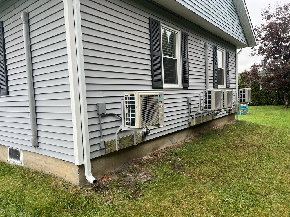
Installs completed, These work amazing, Whisper quiet, And can cool a room in short order.
-
It’s raining now
-
67/66 It's gonna rain.
-
Rain today or no
-
Records: Highs: EWR: 99 (1999) NYC: 96 (1925) 94 in 1999 * / 2008 LGA: 97 (1999) JFK: 92 (1999) Lows: EWR: 48 (1945) NYC: 47 (1879) LGA: 50 (2000) JFK: 50 (2000) Historical: 1816 - A famous June snow occurred in the northeastern U.S. Danville VT reported drifts of snow and sleet twenty inches deep. The Highlands were white all day, and flurries were observed as far south as Boston MA. (David Ludlum) 1816: FAMOUS JUNE SNOWSTORM; "YEAR WITHOUT A SUMMER" -- 20 inch snowdrifts in Danville, VT flurries in Salem and Boston, MA A famous June snow occurred in the northeastern U.S. Danville, VT reported drifts of snow and sleet twenty inches deep. The Highlands were white all day, and flurries were observed as far south as Boston, MA.(David Ludlum) Upstate, NY received 3 inches of snow (p.33 Washington Weather Book 2002 by Ambrose, Henry, Weiss) 1816: The following is found on page 31, from the book, "History of the American Clock Business for the Past Sixty Year, and Life of Chauncey Jerome," written by Chauncey Jerome. The book was published in 1860. "The next summer was a cold one of 1816, which none of the old people will ever forget, and which many of the young have heard a great deal about. There was ice and snow in every month of the year. I well remember on the seventh of June, while on my way to work, about a mile from home, dressed throughout with thick woolen clothes and an overcoat on, my hands got so cold that I was obliged to lay down my tools and put on a pair of mittens which I had in my pocket. It snowed about an hour that day." This bitter cold event occurred in Plymouth, Connecticut. 1885: A severe thunderstorm dropped hail up to 4 inches in diameter and spawned a tornado at Parkhill St.Thomas, Ontario Canada. Homes and orchards were damaged.(Ref. Wilson Wx. History) 1907: A violent tornado moved across Washington County, from near Covington to New Minden, IL. Near the tornado's endpoint, 4 people were killed while running to their storm cellar. Another violent tornado in southern Clark County destroyed or damaged every building in Old York. The tornado tracked for 15 miles, crossing into Indiana. (Ref. Wilson Wx. History) 1908: An F3 tornado touched down in Hillsboro, WI and then moved northeast to just southeast of Mauston, WI. About 4 miles south of Mauston, the tornado killed a farmer and his son as they ran for their storm cellar. Another F3 tornado tracked northeast from 9 miles northwest of Charles City, IA to two miles northeast of Charles City. It left only the floor boards on a small farm house about 5 miles northwest of Charles City. In the east part of Charles City, 5 homes were destroyed and 20 others were severely damaged. A man was killed by a falling chimney and 10 others were injured. About 200 buildings were damaged. (Ref. Wilson Wx. History) 1953: An F4 tornado near Arcadia, NE killed 11 people, beginning a 3-day stretch of killer tornadoes that spread into the eastern U.S. Scottsbluff, NE received its greatest daily precipitation on record when 3.18 inches of rain deluged the city. (Ref. Wilson Wx. History) 1972 - Richmond VA experienced its worst flood of record as rains from Hurricane Agnes pushed the water level at the city locks to a height of 36.5 feet, easily topping the previous record of thirty feet set in 1771. (The Weather Channel) 1980: Thunderstorms caused downed trees and power lines as well as street flooding all across western New York State. A wind gust of 79 mph was observed at greater Buffalo International Airport. Golf ball sized hail was reported north and east of the city. A rare flash of St. Elmo's fire knocked out the Weather Service's radar and telephone lines for about 10 minutes as the storm passed. Air controllers at the Buffalo Airport said the control tower received a direct lightning strike that blackened out the air control computer for a short period. (Ref. Wilson Wx. History) 1983: Miami, FL dropped to an overnight low temperature of 80° which set a new record for the highest minimum temperature at that location.(Ref. Wilson Wx. History) 1984: 42 tornadoes touched down in the Upper Midwest with 21 of them occurring in Iowa. An F4 tornado tracked 30 miles through Mahaska and Keokuk Counties in Iowa, killing two people and injuring 51 others. The small town of Wright was practically wiped out. Barneveld, WI was devastated shortly before midnight as an F5 tornado chewed up the town. 90% of the town was damaged or destroyed, nine people were killed, and 197 were injured. (Ref. Wilson Wx. History) 1987 - Thunderstorms in the Laramie Mountains of eastern Wyoming produced golf ball size hail, and up to five inches of rain in just one hour. Half a dozen cities in the Upper Mississippi Valley reported record high temperatures for the date, including La Crosse, WI, with a reading of 97 degrees. (The National Weather Summary)(Storm Data) 1988 - Snow whitened some of the mountains of northern California and northwestern Nevada. Twenty-six cities in the central and eastern U.S. reported record high temperatures for the date, including Rapid City SD with a reading of 104 degrees, and Miles City, MT, with a high of 106 degrees. (The National Weather Summary) 1989 - Thunderstorms produced severe weather from southern Oklahoma and eastern Texas to northwestern Florida through the day and night. Thunderstorms spawned 22 tornadoes, including a dozen in Louisiana, and there were 119 reports of large hail and damaging winds. A strong (F-2) tornado at Gross Tete LA killed two persons, injured thirty others, and another strong (F-2) tornado injured 60 persons at Lobdell LA. Softball size hail was reported at Hillsboro TX. (The National Weather Summary) (Storm Data) 1993: Thunderstorms erupted over western Iowa, with many producing hail. Damage at one car dealership in Carroll was estimated at $250,000 dollars and another at Estherville had $100,000 dollars in damage. At Arnolds Park, 65 mph winds lifted boats from their moorings. The strongest tornado was in Lyon and Osceola Counties where it was on the ground for 10 miles. In Sibley, IA one roof was taken off of a house and a high school bus barn was severely damaged causing about $150,000 dollars in damage. A huge tornado touched down in northwest Minnehaha County in South Dakota and cut a swath of destruction 55 miles long and one half mile wide. Most structures within the path of the tornado were little match for the storm which packed winds estimated between 210 and 260 mph. Numerous farms and residences were destroyed and trees snapped off or uprooted. Parts of the Chicago, IL metropolitan area were flooded after thunderstorms produced 2 to 5 inches of rain in a 3-hour period. This type of a rainstorm in that area has an average occurrence rate of once every 30-60 years. Over the period of a day, up to 6.50 inches of rain fell, producing one of greater floods noted in that area. The deep tunnel flood control system under the south side of Chicago which holds 185 million gallons of water was filled. (Ref. Wilson Wx. History)
-
Yeah not all HECS are top 10- the Jan 2016 storm wasn't here, and March of 93 wasn't even top 20. The early Jan storm was probably top 15 here if I had the energy to do a ranking. The lowlands have been on a pretty good roll with significant Jan snowstorms in recent winters.
-
rain just restarted here fortunately. it had been dry here for at least 6 or 7 hours and I was getting worried about possible drought conditions.
-
72 / 68 highest dew points in a while. Another period of 72 - 96 hours of mainly cloudy conditions coinciding with a weekend. Showers / pop up storms Sat - Sun - Mon - Tue with 0.50 - 1.00+ heaviest storms spots as frontal boundary lingers over or nearby. Clears out and warms up Wed - Fri with next chance of 90 in the hotter areas of C-n _NJ of this regional group. Next front arriving next weekend 6/14 - 6/15. Beyond there overall warm with heat from west building north and east towards the 20th along with heights. 6/7 - 6/10 : Cloudy wet - rain chances 6/11 - 6/13 : Much warmer - dry perhaps stray 90 6/14 - 6/17 : Front nearby - more clouds / rain -storms 6/18 - Byond : Hotter by the 20th - overall warmer than normal
-
It was terrible yesterday . I don’t put much faith in it
-
HRRR looks good for you from 1-3, may nip me too.
-
Looks pretty wet this afternoon for a 2-3 hour period
-
Looks like possible 7/10 split here in CT


