All Activity
- Past hour
-

Invest 94L—90% 2 day and 90% seven day odds of development
GaWx replied to WxWatcher007's topic in Tropical Headquarters
12Z Euro to 78 looks similar to 0Z -
I mean, this is basically doing a @Ji where the D9 blizzard run becomes the floor and anything less is a bust.
-
Keep this up and it might outdo winter storm posts.
-

E PA/NJ/DE Autumn 2025 Obs/Discussion
RedSky replied to PhiEaglesfan712's topic in Philadelphia Region
.80" total meh -
Another year of more spider posts than severe.
-
 PTC likely later today Tropical Weather Outlook NWS National Hurricane Center Miami FL 200 PM EDT Fri Sep 26 2025 For the North Atlantic...Caribbean Sea and the Gulf of America: Active Systems: The National Hurricane Center is issuing advisories on Hurricane Humberto, located over the subtropical central Atlantic, and has issued the last advisory on Post-Tropical cyclone Gabrielle over the northeastern Atlantic. Southwestern Atlantic (AL94): Satellite data and surface observations indicate that a low pressure system appears to be forming near eastern Cuba and the southeastern Bahamas. This system is producing a large area of disorganized showers and thunderstorms, and gusty winds. Gradual development of this system is expected, and it will likely become a tropical depression during the next day or so while it moves northwestward or northward across the central and northwestern Bahamas. Regardless of development, heavy rains and gusty winds are ongoing in the Dominican Republic, Haiti, the Turks and Caicos Islands, the southeastern Bahamas and eastern Cuba, and are likely to spread across the remainder of the Bahamas over the weekend. Interests in all of these areas should monitor the progress of the system. Tropical storm watches or warnings could be required for portions of the Bahamas and advisories on a potential tropical cyclone could be issued as early as later today. While there remains considerable uncertainty in the long-range track and intensity of the system, there is a significant risk of wind, rainfall, and storm surge impacts for a portion of the southeast U.S. coast early next week. Interests in this area should also monitor the progress of the system. * Formation chance through 48 hours...high...90 percent. * Formation chance through 7 days...high...90 percent. $$ Forecaster Cangialosi/Reinhart/Hagen
 -

September 2025 OBS-Discussion centered NYC subforum
Superstorm replied to wdrag's topic in New York City Metro
Wow! Incredible stat. -
I'd take that
-
weird as hell
-
So we fail upwards then.
-
How did you get a larger gif to post?
-
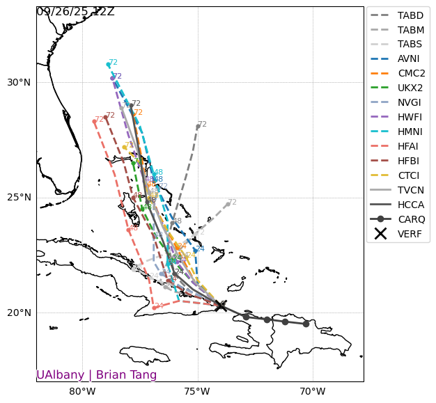
The Canadian keeps future Imelda offshore, but the massive ridge over the top blocks its escape and runs it up the coast. Funky.
-
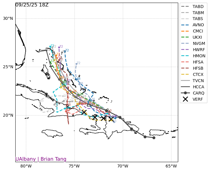
Invest 94L—90% 2 day and 90% seven day odds of development
GaWx replied to WxWatcher007's topic in Tropical Headquarters
Other 12Z: Icon goes OTS again JMA hints at OTS but not sure since only to 72 UKMET goes OTS again like the Icon although it goes further NW than prior runs before going OTS NEW TROPICAL CYCLONE FORECAST TO DEVELOP AFTER 42 HOURS FORECAST POSITION AT T+ 42 : 23.3N 76.7W LEAD CENTRAL MAXIMUM WIND VERIFYING TIME TIME POSITION PRESSURE (MB) SPEED (KNOTS) -------------- ---- -------- ------------- ------------- 1200UTC 28.09.2025 48 24.2N 76.7W 1007 33 0000UTC 29.09.2025 60 25.2N 77.4W 1004 34 1200UTC 29.09.2025 72 26.7N 77.8W 1003 38 0000UTC 30.09.2025 84 28.2N 77.6W 1001 36 1200UTC 30.09.2025 96 28.9N 78.5W 996 42 0000UTC 01.10.2025 108 28.7N 77.8W 994 40 1200UTC 01.10.2025 120 28.5N 76.6W 992 38 0000UTC 02.10.2025 132 28.7N 74.3W 991 46 1200UTC 02.10.2025 144 28.9N 72.2W 991 54 0000UTC 03.10.2025 156 28.7N 69.6W 992 63 1200UTC 03.10.2025 168 28.6N 68.4W 995 52 -
What are you talking aboot?
-
A lot of yall are really trying to get banned.
-
The Canadian, as usual, is funky.
-

September 2025 OBS-Discussion centered NYC subforum
donsutherland1 replied to wdrag's topic in New York City Metro
The consistency has been remarkable. Smallest Mean Temperature Standard Deviation for September (through September 25th for 2025) for Central Park: 1. 1968 3.43° 2. 2025 3.75° (10th smallest difference between the mean temperatures for the first and second halves of September) 3. 1870 3.81° (6th smallest difference between the mean temperatures for the first and second halves of September) 4. 2024 3.94° 5. 1908 4.08° -
 CMC stalls it, heads east as it interacts with Humberto, then gets left behind and landfalls into NC as an strong intensifying hurricane
 -
Not to mention the onshore flow. A further south track with that flow over Charleston would be very bad. The Low Country is called that for a reason (I used to live in SC).
-
I’m very worried. This has high end flood potential written all over it even if it stalls just off the coast
-

Invest 94L—90% 2 day and 90% seven day odds of development
eyewall replied to WxWatcher007's topic in Tropical Headquarters
I am starting to wonder about an eventual stall as this thing gets near the coast or perhaps a little inland. -

Invest 94L—90% 2 day and 90% seven day odds of development
wthrmn654 replied to WxWatcher007's topic in Tropical Headquarters
It will though be a wet storm so that's basically a given -
It’ll be an interesting test case for sure if the whole N PAC is warm vs the 2/3 of the western Pacific.
- Today
-
Invest 94L—90% 2 day and 90% seven day odds of development
wthrmn654 replied to WxWatcher007's topic in Tropical Headquarters
Something I don't think anyone has talked about/ mentioned but this L has been tracking against guidance, nearly due west since at least 18z yesterday... i mean just look at the actual track versus modeling at 18z with each x. Being 00,06,12z actual placement...... this will likely dictate storms overall intensity the closer to Florida it gets along with all the islands is gotta cross. With 12z runs showing this likely a TS possibly barely a Cat 1 maximum strength wise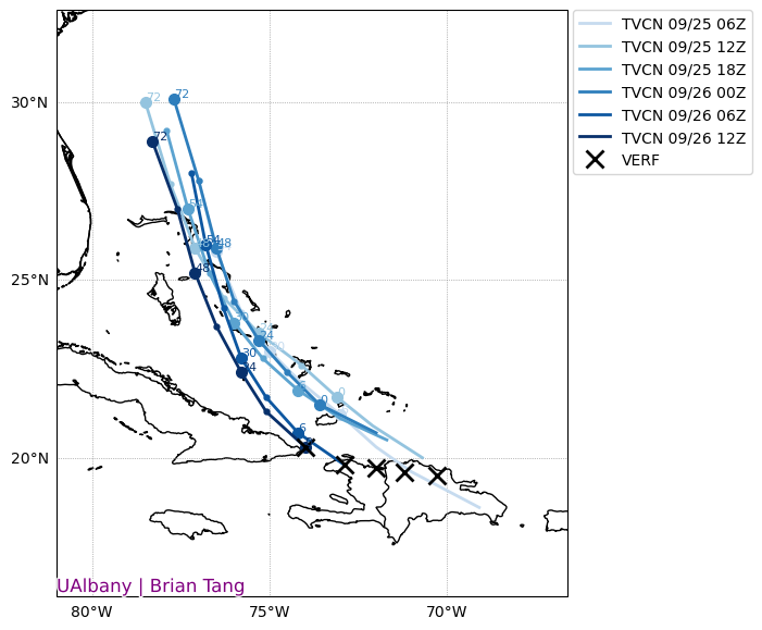
-
Yeah this looks like a low end wind event current compared to other events.


