All Activity
- Past hour
-
 Doesn’t feel bad outside yet. DP still in the 50s. Probably had the last morning low in the 50s for a while though, 58 in Syosset and 59 in Muttontown.
 -
Fires? Theres a ton up there
-
 Jun 27 - Jul 8 2012 was close at 11 days the other days around there were 89.
 -
 it's disappointing, it reminds me of that perfect game pitched by that Tigers pitcher with the umpire making a bad call on the *should have been* last play of the game.
 -
Yes the heatwaves are not strong enough to make it into our area. I expect 10 day heatwaves are much more common in NJ because their summers are usually at least 5 degrees hotter than ours.
-
Pinatubo induced Summer 1992 was such an outlier. I remember rainy days in the 40s that summer in the Poconos.
-
clear blue skies, nothing bad about that
-
Was it 1995 when the Pope was in NYC (Pope John Paul II) at that time when NYC recorded 86 at or after October 20th? I dimly remember it, it was very humid and a bunch of people fainted trying to see the Pope. It happened because of a Gulf TC that went to our west up around Pittsburgh, I think. Opal?
-
None in NS right now.
-
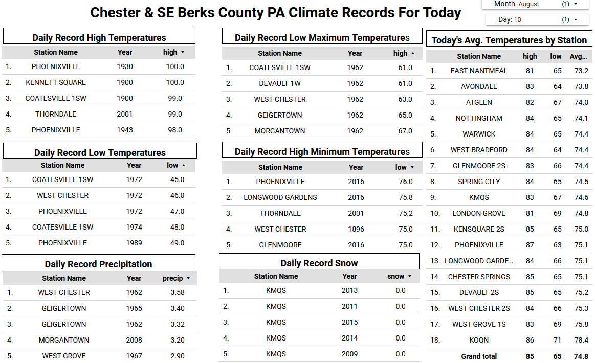
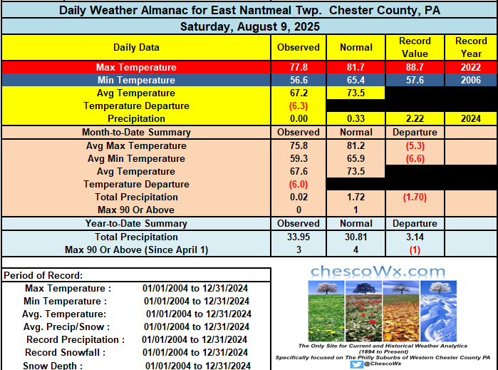
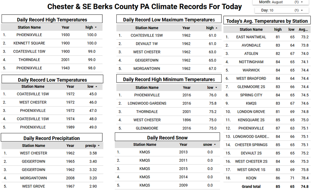
Yesterday was our 3rd record low of the month here in East Nantmeal besting the old record set Saturday in 2006 (records back to 2004) This is nowhere close to the County record of 49 degrees set in Phoenixville back in 1989. We should see a warming trend starting today with temperatures even here in East Nantmeal reaching the 80's for just the 2nd time this month. We continue to warm through Wednesday when some lower spots will likely reach 90 degrees. A few degrees cooler to close out the week with a chance of showers starting Wednesday evening.
-
Methinks Tuckers 66yd FG record will be beat this season. Jags Little hit one for 70 yesterday
-
Are you signed into the AmWx website on the new phone?
-
 the worst week of the summer is behind us
 -
 Several spots only got a T to .01. But it goes to show how quickly we can get to record heat when we get dry in the much warmer climate. SMQ made it to 87° last October 22nd. That was the latest 87° in the year that I was able to find for NJ. If that flash drought started over the summer and lasted into October, then 90° would have been possible. Data for October 22, 2024 through October 22, 2024 Click column heading to sort ascending, click again to sort descending. SOMERSET AIRPORT WBAN 87 INDIAN MILLS 2 W COOP 85 NEW BRUNSWICK 3 SE COOP 85 SOUTH JERSEY REGIONAL AIRPORT WBAN 85 SUSSEX AIRPORT WBAN 85 New Brunswick Area ThreadEx 85
 -
Low of 52 Saw a meteor around 11pm last night. Perseid meteor shower this week.
-

E PA/NJ/DE Summer 2025 Obs/Discussion
ChescoWx replied to Hurricane Agnes's topic in Philadelphia Region
Yesterday was our 3rd record low of the month here in East Nantmeal besting the old record set Saturday in 2006 (records back to 2004) This is nowhere close to the County record of 49 degrees set in Phoenixville back in 1989. We should see a warming trend starting today with temperatures even here in East Nantmeal reaching the 80's for just the 2nd time this month. We continue to warm through Wednesday when some lower spots will likely reach 90 degrees. A few degrees cooler to close out the week with a chance of showers starting Wednesday evening.
-
CAM ON ERIN Special outlook lads!!! Special outlook issued to update discussion of the disturbance located southeast of the Cabo Verde Islands (AL97). BAM BAM BAM 1. Eastern Tropical Atlantic (AL97): Updated: Recently received satellite-derived wind data indicate that a well-defined low pressure system has formed about midway between the west coast of Africa and the Cabo Verde Islands with maximum winds of about 35 mph. Although the associated shower and thunderstorm activity still lacks some organization, only a small increase in the organization could lead to the formation of a tropical depression before the low moves near or across the Cabo Verde Islands tonight and on Monday. Regardless of development, locally heavy rainfall and gusty winds are possible today and Monday across the Cabo Verde Islands, and interests there should monitor the progress of this system. Even if a tropical depression does not form over the next day or so, environmental conditions appear conducive for later development, and a tropical depression is likely to form by the middle to latter portion of this week while moving west-northwestward at 15 to 20 mph across the eastern and central tropical Atlantic. * Formation chance through 48 hours...medium...40 percent. * Formation chance through 7 days...high...80 percent.
-
Nice evening to be out watching the full-moonrise. Not looking forward to the heat returning.
-
Ill click on quote or try to rate a post and nothing, it's like I'm clicking on space
-
 Central Park finished the August 1-10 with 9 low temperatures below 70°. The last time that happened was August 2017. The August 1-10, 2025 average low of 65.2° was the lowest August 1-10 average since 1992 when the mean low was 64.4°.
 -
 The air is different today. Humidity up, heat is higher. Already 80 here with a dewpoint creeping up now just into the 60s. We have entered our crappier weather period.
 -
Is that smoke coming in from the northeast from the fires in Nova Scotia?
-
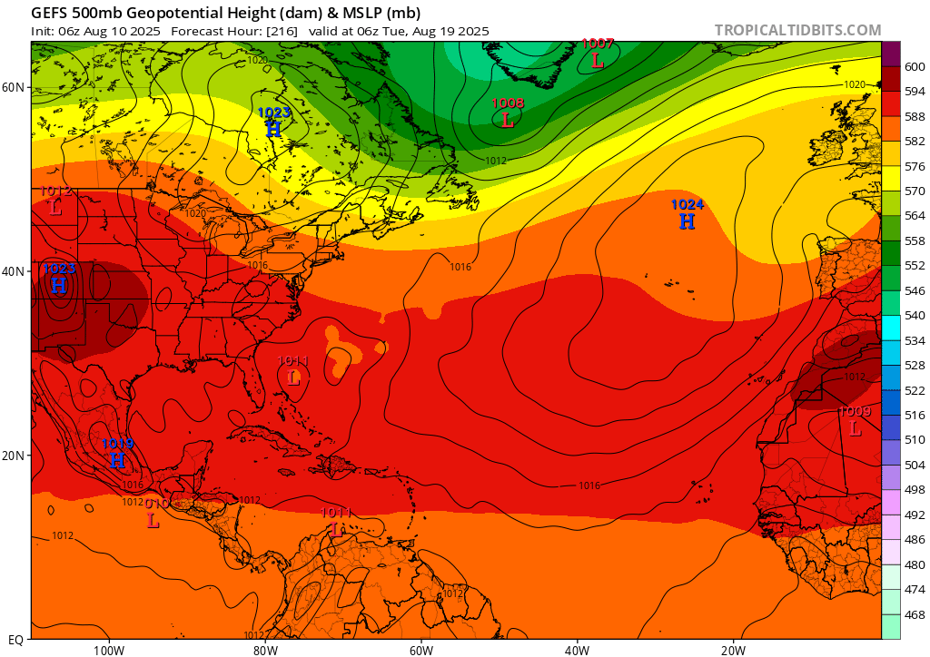
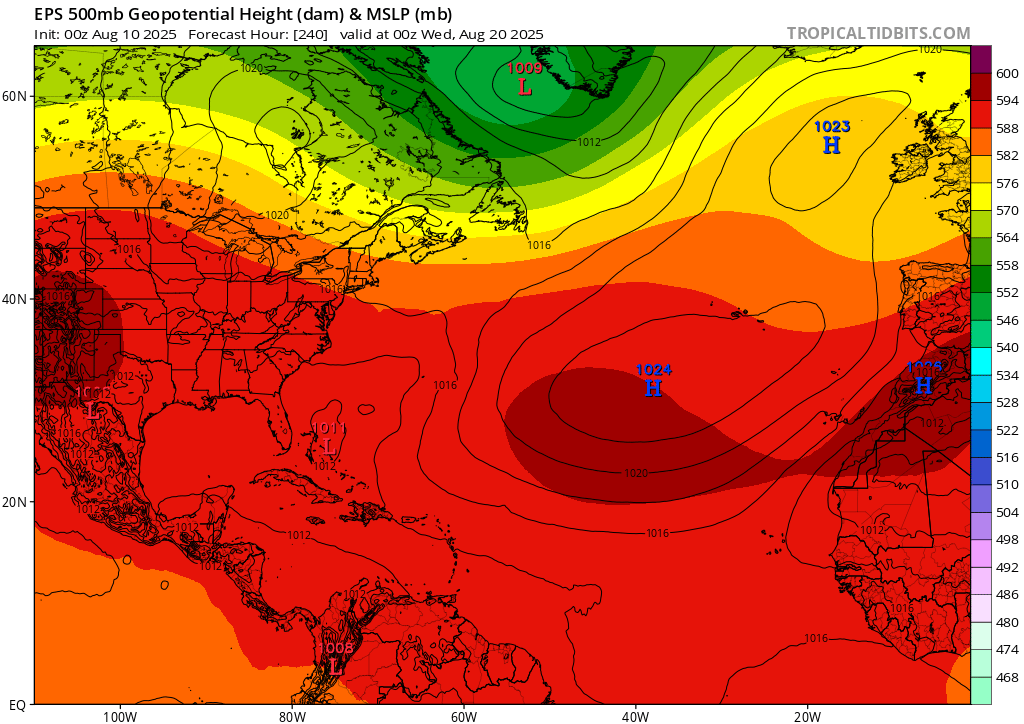
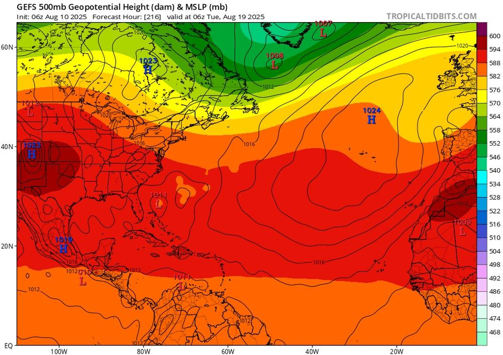
In my opinion the GEFS/EPS are telling us that too much latitude early on will not be the issue for a potential track close to New England. We have pretty solid agreement on that within 10 days. What is a much bigger issue is the strength of the western Atlantic ridge after day 10. This critical piece is seeing huge run to run variation, so tons of uncertainty there… Imo this will be a long and fun one to track at least.

-
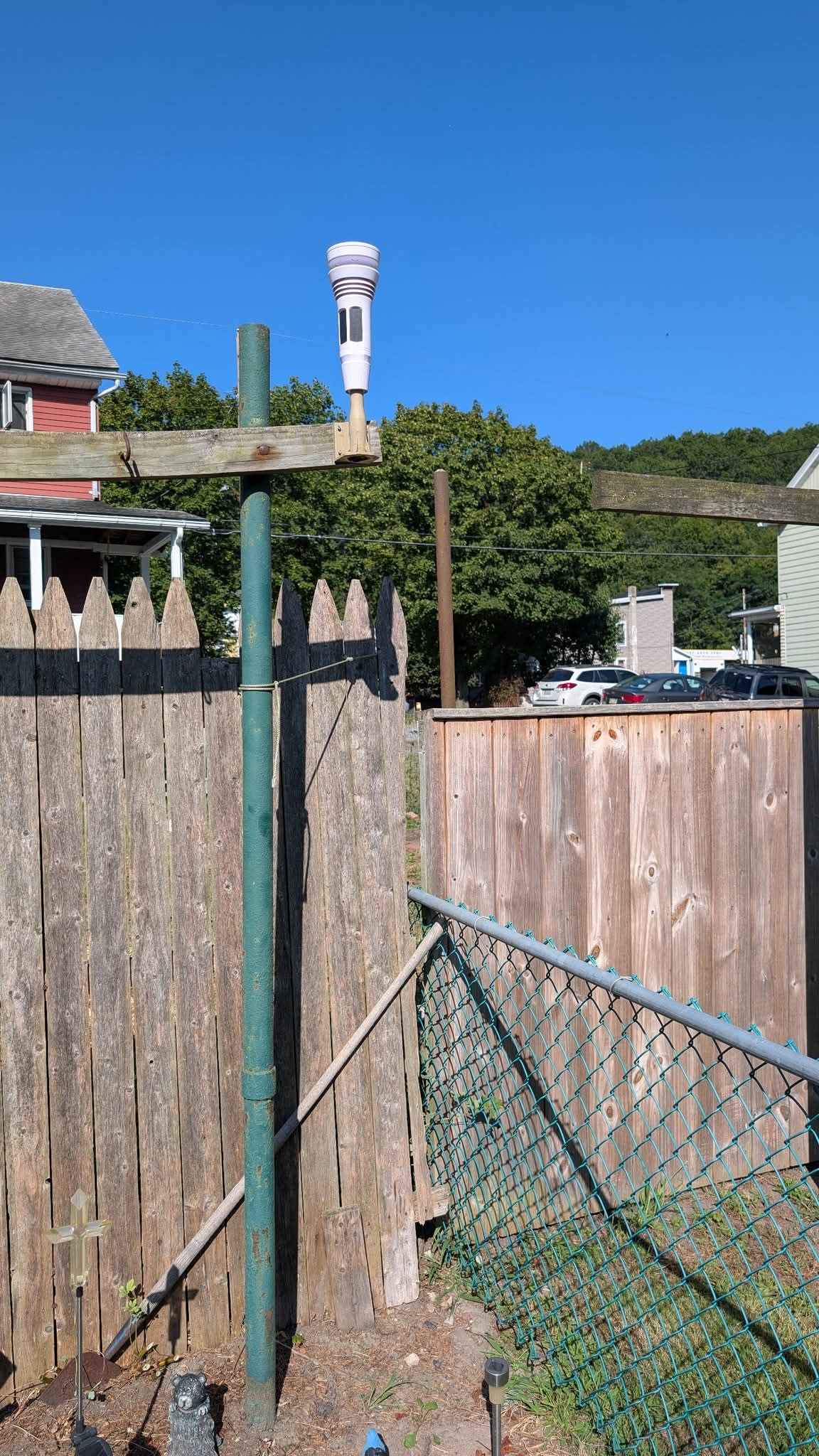
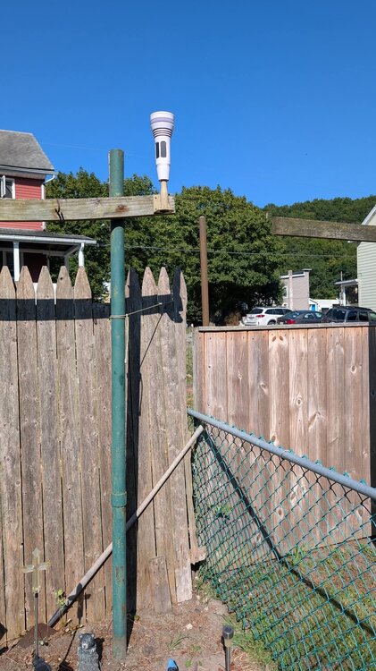
I moved my Tempest once again to a much more stable location. The neighbors removed a big pine tree opening the spot up for me. It's solid now. The "jury rigged" clothesline props was a bit shaky, and I thought if we got a good enough windy thunderstorm that it might come down. It's not going anywhere here, but is still above the fence, and a bit farther away from the house.
-
what's happening specifically?