All Activity
- Past hour
-
I haven’t seen much guidance that gives any confidence of 6+ out there. Prob will go with WWA tomorrow for E Suffolk and around BDR
-

26th-27th event, coming at us like a wounded duck.
WxWatcher007 replied to Go Kart Mozart's topic in New England
I think you may have it worse than Chief Wiggum -
There’s the Christmas spirit. Sent from my iPad using Tapatalk
-

26th-27th event, coming at us like a wounded duck.
CoastalWx replied to Go Kart Mozart's topic in New England
They can have it. Too much disappointment there. -
Sent from my iPad using Tapatalk
-
.SHORT TERM /THURSDAY NIGHT THROUGH SATURDAY NIGHT/... -- Changed Discussion -- What`s Changed: A winter storm watch has been issued for the Lower Hudson Valley, Northeast New Jersey, NYC metro, Nassau, Western Suffolk, and Fairfield County 5pm Friday through 1 pm Saturday. Key Messages: * Confidence in a winter storm impacting the area Friday evening through Saturday morning continues to increase. * Heavy snow is possible Friday night/early Saturday morning. Total accumulation ranges from 4 to 8 inches in the watch area and 2 to 5 inches east of the watch in SE CT and east end of Long Island. Guidance continues to come into agreement on a winter storm moving across the region Friday evening into Saturday morning. A fast moving shortwave and associated middle level energy will traverse around the periphery of an anomalously strong upper ridge over the central states. Ahead of the system, arctic air will advect southward over the northeast Thursday night as high pressure settles over Quebec and ridges down into the area. This high slows down due to blocking over the North Atlantic, which allows the cold air to lock into place over the area through Saturday. Low pressure associated with the aforementioned shortwave energy will approach late Friday and pass across the Middle Atlantic Friday night into Saturday morning. The low should then move further offshore Saturday afternoon. With arctic air in place on Friday (highs in the upper 20s to around 30, and dew points in the single digits), any precip will have a difficult time reaching the ground. This is especially through the middle of the afternoon. Lift ahead of the system begins to increase and saturation will begin from the mid and upper levels and eventually down to the surface by evening. Snow should begin to reach the surface late afternoon and especially in the evening from around the NYC metro on north and west. Further east, it may take a bit more time to saturate and break through the dry air and surface ridging, with accumulating snow likely here overnight Friday into early Saturday morning. Snow, potentially heavy at times, is expected Friday night. Where uncertainty lies is where any heavier bands will set up. We are still just outside the range of the higher resolution modeling. However, there are signals in the global models that hint that heavy banding may set up over portions of the area, especially within the watch. There is an impressive thermal gradient with the arctic air over New England, with milder air further south and west over the Ohio Valley. Mid level frontogenesis (H7) will increase substantially Friday evening and continue through early Saturday morning. The region also lies within the left exit region of the upper jet allowing for larger scale lift to coincide with the middle level lift. Lift should begin to weaken Saturday morning, but there may be some left over light snow across some parts of the area in the morning before ending midday. The region of the strongest lower/middle lift remains in question and may fluctuate a bit over the next several model cycles, but overall the general idea does not change with this upcoming event. Probabilities have increased for a warning level (6" or more of snow) with the latest with the latest WPC WWD and NBM. This has led to an increase in the areal coverage of higher probabilities (around 50%) in the WPC WSO. Based on these trends as well as increasing confidence in evolution of the system, have issued a winter storm watch for all but the east end of Long Island and south central and eastern Long Island. Confidence lowers a bit across Long Island and southern Connecticut, but felt western Suffolk and Fairfield were close enough to warning criteria to include in a watch. There is greater uncertainty further east due to the interaction with the lingering surface ridging/dry air and overall lower liquid equivalents. Snowfall Forecast: 4 to 8 inches possible within the watch area and 2 to 5 inches further east outside of the watch. A reasonable worst case scenario of 8 to 10 inches currents exists within the watch area with potential locations further east could still see warning criteria met. Snowfall rates: Peak rates around 1 inch per hour possible. There is a low chance rates could come close to 2 inches per hour in heavier banding. The snow may initially begin with a higher ratio (drier snow) and then trend to a lower ratio (wetter) as the storm moves across the area. This will be fine tuned over the next day or so as high range guidance comes into range and the event draws closer. There is still some concern with the warm advection aloft Friday night bringing in a mix with sleet late in the event. Some earlier model runs were showing this potential. The latest NBM probability of sleet is very low and trends seem to be leaning towards keeping the precipitation all snow across the area. Models can sometimes underestimate the warm advection aloft. This is something that will need to be watched, especially for parts of northeast NJ and interior Lower Hudson Valley as this is the direction the warm air aloft tries to move in from the west. There are no wind concerns with this event as the pressure gradient is relatively weak. Temperatures Thursday night will bottom out in the teens to lower 20s. Highs on Friday will only be in the upper 20s to around 30. Temperatures during the snow Friday night should be in the mid to upper 20s with highs on Saturday struggling to rise above freezing -- End Changed Discussion --
-
Two days in a row of disc golf with one of my boys! This has been fantastic! Maybe again on Saturday? .
-
Yet we got 8” of snow out here last week.
-
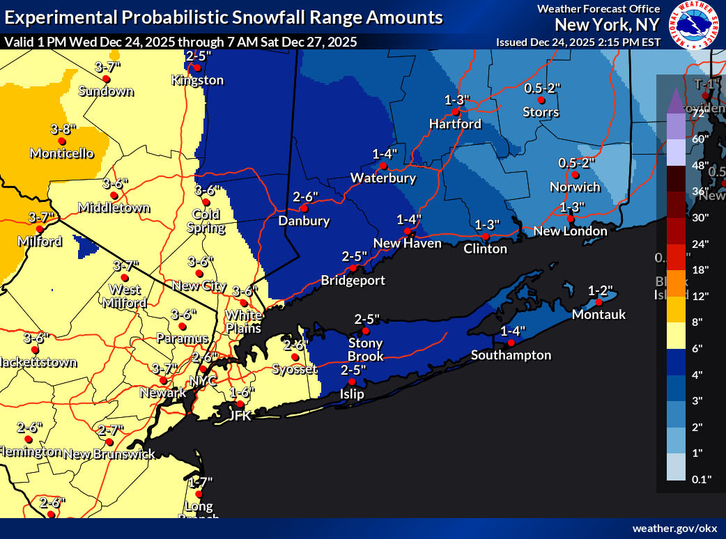
Michael- Right now, the highest confidence for a warning level snowfall is across the western portions of our forecast area. (west of eastern Long Island). We will continue to monitor data over the next 12-24 hours and see if adjustments to the forecast needs to change. But right now, the best chance for 6+ inches appears to be west of eastern Long Island
-

26th-27th event, coming at us like a wounded duck.
Sey-Mour Snow replied to Go Kart Mozart's topic in New England
NYC's small payback for 2015 -
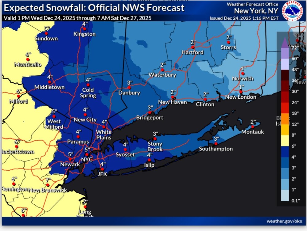
Snow maps have gone up too. Old point map versus new range map
-

White Christmas Miracle? December 23-24th
TauntonBlizzard2013 replied to Baroclinic Zone's topic in New England
16th straight bare Christmas. Let’s make it 20!!! -
26th-27th event, coming at us like a wounded duck.
TauntonBlizzard2013 replied to Go Kart Mozart's topic in New England
Nope. 0 return hobby -
You are correct sir. Was guessing a bit, since the AFD wasn't out when I wrote that. Here's what they said: "There is greater uncertainty further east due to the interaction with the lingering surface ridging/dry air and overall lower liquid equivalents."
-
WSW up here for 5-8"
-
I wish I took a screenshot of the mount holly report that day. I'm sure I can find it, but let's I remember Elizabeth got 36 and Brick got 39. I just remember being in Jackson, NJ and shoveling the deck to make sure it wouldn't collapse. Never had to do that before.
-
And suddenly my zone forecast has gone crazy: but no watch Friday A 20 percent chance of snow after 1pm. Increasing clouds, with a high near 30. North wind 6 to 9 mph. Friday Night Snow. Low around 22. Chance of precipitation is 80%. New snow accumulation of 3 to 7 inches possible. Saturday A 50 percent chance of snow before 1pm. Cloudy, with a high near 34.
-
Uh, sleet? I don't think that's what they are expecting for eastern Suffolk lol
-

26th-27th event, coming at us like a wounded duck.
RUNNAWAYICEBERG replied to Go Kart Mozart's topic in New England
It’s just not fair. -
feels real good on Christmas eve....
-

Boxing Night Snow/Sleet/Ice Dec 26-27 Storm Thread/Obs.
Kevin Reilly replied to Mikeymac5306's topic in Philadelphia Region
Well I see Chester and Delaware counties and Southwestern New Jersey are getting coal for Christmas no Winter Storm Watch here lol. This goes right along with my thinking earlier Winter Weather Advisory SE Pennsylvania and Winter Storm watches north and northeast. The more important snow line I-76 points northwest, north, and northeast. -
Looks to be on par with the other snow event we got recently here aka 5-6" near Somerset.
-
26th-27th event, coming at us like a wounded duck.
TauntonBlizzard2013 replied to Go Kart Mozart's topic in New England
Winter storm watch for NYC while I stare down a 16th straight bare Christmas -

White Christmas Miracle? December 23-24th
Lava Rock replied to Baroclinic Zone's topic in New England
Sorry, that sucks Sent from my SM-S921U using Tapatalk -
I did this for folks elsewhere so thought folks might like this summary of all the watches for NWS-Philly and NWS-NYC, as well as the map of watches and the new snowfall map. Getting officially excited as my point-and-click is up to 6.9"... Winter storm watches up for most of the region (counties in grey), so the forecast is obviously gaining in confidence, but still some uncertainty in how far north/northeast the warm air aloft makes it, turning snow to sleet for some of the storm (outright plain rain is looking unlikely for any part of CNJ). Watches are up for the following areas for the snow/sleet and ice amounts listed with some comments from looking at the point/click forecasts which are not explicitly listed in the watches. For 4-6" for Camden, Coastal Ocean, Northwestern Burlington, Ocean, and Southeastern Burlington Counties; for this area, the NWS is expecting some of that to be sleet, which could keep accumulation depth down For 4-6" and up to 0.2" ice glaze for Carbon-Berks-Lehigh-Northampton-Philadelphia-Western Montgomery-Eastern Montgomery-Upper Bucks-Lower Bucks Counties; obviously the NWS feels there's more chance of sleet and then freezing rain here For 5-8" for Sussex-Warren-Morris-Hunterdon-Somerset-Middlesex-WesternMonmouth-Eastern Monmouth-Mercer-Monroe; NWS is basically calling for all snow for these counties For areas SW of the Philly/Camden/Burlco counties, the NWS-Philly is still predicting a few inches of snow, then sleet, then rain as those areas will be closer to the warmer air aloft from the storm; these areas will likely get advisories tomorrow. For 4-8" for almost the entire NWS-NYC area, i.e., Northern Fairfield-Southern Fairfield-Western Passaic-Eastern Passaic-Hudson-Western Bergen-Eastern Bergen-Western Essex-Eastern Essex-Western Union-Eastern Union-Orange-Putnam-Rockland-Northern Westchester-Southern Westchester-New York (Manhattan)-Bronx-Richmond (Staten Island)-Kings (Brooklyn)-Northwest Suffolk-Southwest Suffolk-Northern Queens-Northern Nassau-Southern Queens-Southern Nassau; the only exception is eastern Suffolk, where they expect sleet to keep accumulations down. All of the watches are in this link: https://forecast.weather.gov/wwamap/wwatxtget.php?cwa=PHI&wwa=winter storm watch