All Activity
- Past hour
-

Pittsburgh/Western PA WINTER ‘25/‘26
jwilson replied to Burghblizz's topic in Upstate New York/Pennsylvania
NBM is finally working again. Average precip on the 1 UTC run is 0.88" equating to a mean of 11.4" of snow. Spread is 11 to 15 between Saturday and Sunday. 70% chance of >12", 96% chance of >8" (which is somewhat nutty). That's all at PIT; odds are slightly better at AGC, actually, because of the presumably better rates. 74% and 97%, respectively. Non-snow peak odds are later on Sunday at 11% chance of rain compared to 78% chance of snow. I'm guessing that's picked up mostly by the group of mesos that are showing a warm tongue/small dry slot. I still don't like how close the primary comes to our area. Typically, when that does happen, we change over south of the city. The thermal profiles on all the models check out, but I guess it depends how much you trust them to handle the microclimate. Bufkits for NAM and GFS are all snow at AGC. Between 10" and 13" depending on the run. Ratios aren't great, so any improvement there means more accumulation. 0Z NAM actually barely gets above 10:1 the entire duration. Max is 12:1 except for a brief period of 21:1 at the tail end on 1.33" of QPF (high). That's why storm total is "only" twelve inches. If I had to do a first call, I'd probably go a little conservative on the southern regions of Allegheny, Washington, Greene, and Fayette (Mon Valley): 8" to 14" - 6" to 8" at MGW, less points south - 10" to 14" city points north. Any mesoscale banding that takes place has a significant impact on localized totals because of convergence and associated divergence. Could see lollipops of 16" somewhere in the coverage area. It's arguably low for city-south, but perhaps I'm paranoid. Too many years in MGW. I might adjust that upward tomorrow as more mesos come into confidence range. I think closer to the 8" figure if there's mix/sleet, closer to 14" if there's a clean hit. I still don't necessarily trust the models on thermals assuming the northern progression of the primary low is correct. I'll revisit this thought after the storm. Anyway, just my word vomit. It's 3 AM, give me a break! -
 It might. But do not misinterpret what the Euro and to a greater extent other models have shown. The thrill of this event will be the heavy snow. When the dynamics begin to lift to our north and east some warmer air at upper levels causes some mixing and possibly a brief changeover Sunday night. But by the time this happens almost all the most significant precipitation most likely has fallen. Therefore the greater snow amounts we are seeing on the GFS and the operational Euro. Euro AI is probably overdoing the influx of warmer air at the upper levels as I suspect is NAM. WX/PT
 -

Pittsburgh/Western PA WINTER ‘25/‘26
MikeB_01 replied to Burghblizz's topic in Upstate New York/Pennsylvania
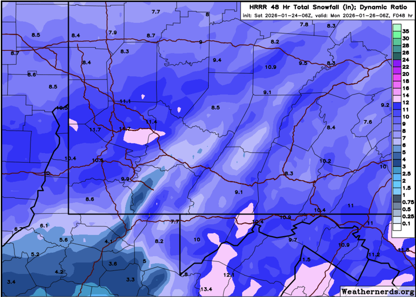
in case you wanted to see it really close up for our area
-
Pittsburgh/Western PA WINTER ‘25/‘26
MikeB_01 replied to Burghblizz's topic in Upstate New York/Pennsylvania
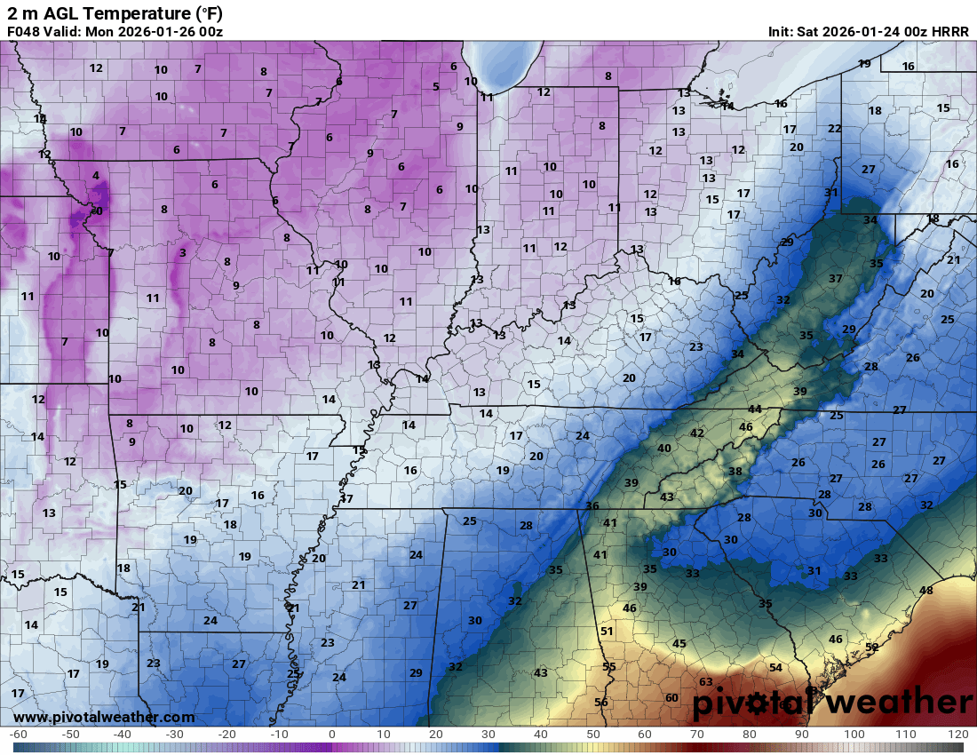
Similar to the 00z HRRR and got some warmer air up into PA. AGC holds on for another solid run. G'night all.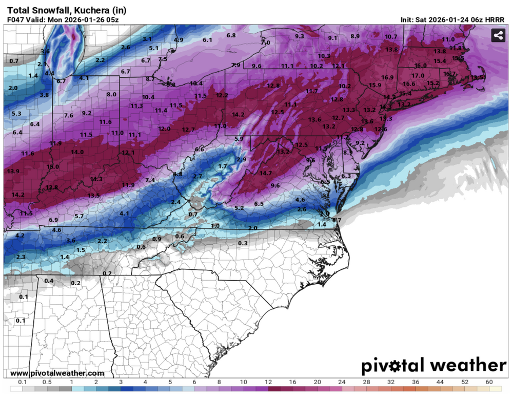
-

Jan 24-26 Weekend Snow and Sleetfest Model Thread Part Tres
jayyy replied to H2O's topic in Mid Atlantic
Euro and HRRR kuch maps with identical outputs for Baltimore. Go figure -
That is a powerful blast of warm air at the surface narrowly shooting all the way to Pennsylvania. I guess we will find out soon if that is in the cards.

-
The snow is way ahead of schedule. It is now showing on my app the snow will start here at 2.45. It’s also snowing down in Oxford.
-

Jan 24-26 Weekend Snow and Sleetfest Model Thread Part Tres
Weather Will replied to H2O's topic in Mid Atlantic
WB 6Z HRRR at 1 am Monday -

Jan 24-26 Weekend Snow and Sleetfest Model Thread Part Tres
EHoffman replied to H2O's topic in Mid Atlantic
We get a seriously insane amount of sleet from 18z-21z. Like .5" of QPF -
Jan 24-26 Weekend Snow and Sleetfest Model Thread Part Tres
Weather Will replied to H2O's topic in Mid Atlantic
WB 6Z HRRR at 4pm Sunday -

Possible Record Breaking Cold + Snow Sunday 1/25 - Tuesday 1/27
Snowlover11 replied to TriPol's topic in New York City Metro
We are a little over 24 hrs from this baby starting and this place is a morgue. Brutal. Guess it isn’t like the old days. -
I'm skeptical of how much warming reaches the surface. I've seen mountain tops in the 50s and valley temps near freezing in these set ups. Seeing the cold get completely scoured with ice on the ground isn't terribly common.
-
Jan 24-26 Weekend Snow and Sleetfest Model Thread Part Tres
jayyy replied to H2O's topic in Mid Atlantic
Still way out there for the HRRR but I’ll accept it -
I'm very curious to see how the surface temps play out in east TN. MRX has Knox hitting 42 and HRRR currently shows 40 peak, but 3k NAM only 35. We'll most likely have a nice heavy cleansing rain to wash away the slop, but it'll be interesting to see how much the surface temps climb with this much variation in the modeling still. Also will be interesting to see what if any backside thump of snow is possible as the 850s crash.
-
Jan 24-26 Weekend Snow and Sleetfest Model Thread Part Tres
EHoffman replied to H2O's topic in Mid Atlantic
Incredible run honestly. DC gets about .1 more QPF vs 00z through 1pm -

Jan 24-26 Weekend Snow and Sleetfest Model Thread Part Tres
yoda replied to H2O's topic in Mid Atlantic
Flip over to all sleet in DC metro is around noon or so -
Jan 24-26 Weekend Snow and Sleetfest Model Thread Part Tres
Weather Will replied to H2O's topic in Mid Atlantic
WB 6Z HRRR at 1 pm Sunday; DC start to flip around 11 am; about an hour later than OZ run. -

Jan 24-26 Weekend Snow and Sleetfest Model Thread Part Tres
AmericanWxFreak replied to H2O's topic in Mid Atlantic
Seems later then a lot of other guidance eh? . -
Jan 24-26 Weekend Snow and Sleetfest Model Thread Part Tres
EHoffman replied to H2O's topic in Mid Atlantic
DC up to 7" by 10am Sunday and still ripping on HRRR...tho we're about to flip -

Texas 2026 Discussion/Observations
Stx_Thunder replied to Stx_Thunder's topic in Central/Western States
I certainly understand there's many people out there who just want to know what's actually going to happen in weather, nothing else. And that's personally fine with me. But it's always better when people would like to (or are willing, more specifically), learn about the meteorological science & parameters in order to really understand what *can* happen. Especially nowadays where it seems like every year we pass now has its own bizarre pattern or systems that are getting more complicated to break down in meteorology. -
Jan 24-26 Weekend Snow and Sleetfest Model Thread Part Tres
Weather Will replied to H2O's topic in Mid Atlantic
WB 6Z HRRR steadier snow by 6am Sunday. -

Possible Record Breaking Cold + Snow Sunday 1/25 - Tuesday 1/27
SnoSki14 replied to TriPol's topic in New York City Metro
Adjusted WSW to 7-13 now which I completely agree with. Front end thump will bring the goods followed by sleet/ZR. It's gonna be a mess 6z HRRR showing that crazy front end dump. Big improvement over 0z -
Jan 24-26 Weekend Snow and Sleetfest Model Thread Part Tres
Weather Will replied to H2O's topic in Mid Atlantic
WB 6Z HRRR: light snow breaking out about 2am Sunday. -
Texas 2026 Discussion/Observations
Stx_Thunder replied to Stx_Thunder's topic in Central/Western States
The primary forcing aloft from the parent mid-level trough out west isn't forecast by the reliable models to start overspreading the state until later today - tonight. Which is why I've been stating the main deal (especially for convective ice/sleet) is going to be Saturday night. It's common to have "lull" or large gap areas of little or no precip between lead shortwave activity like what's ongoing in the state tonight. I have not seen the RRFS in action at all for winter wx events yet. But it does have its moments for MCS (mesoscale convective system) propagation through the state in the spring time. -
Pittsburgh/Western PA WINTER ‘25/‘26
MikeB_01 replied to Burghblizz's topic in Upstate New York/Pennsylvania
honestly, 24 hrs in, the HRRR looks a lot like the euro. Less juicy for some reason, but so far tracking very similarly