All Activity
- Past hour
-
 Below is a list of locations reaching 100° or above in the East:
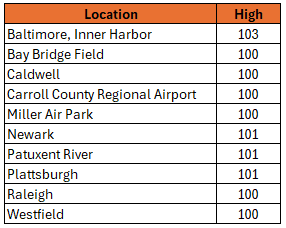
-
79/75 here.
-

June 2025 discussion-obs: Summerlike
LongBeachSurfFreak replied to wdrag's topic in New York City Metro
Yep, without an offshore wind it’s fine. It’s next to impossible to maintain an offshore flow the entire day when the water temp is in the 60s. -
It’s still early for high heat out here, ocean is still cold.
-
He’s had 2 amazing starts and 1 dumpster fire
-
High of 97 and peak heat index 111.7F
-
Yeah I can't can't believe how quick it cool3d off
-
June 2025 discussion-obs: Summerlike
LongBeachSurfFreak replied to wdrag's topic in New York City Metro
Yeah it’s honestly not that bad on the south shore right now. Tomorrow morning while the wind is NW should be the worst for the coast. -
Hi
-
i already got their presents (lifetime subscription to Tapatalk)
-
Agree. 82 never felt so cool.
-
Beautiful evening out there, cooled down nicely, 78
-
High of 96 today after 91 yesterday.....look like will make 4 consecutive of 90+ through Wednesday. My p&c for tomorrow has a high of 103 with a HI of 111...worst I could find....not the jack I yearn for
-
Amazingly hot and humid day. Had a high of 98. Temp didn't drop below 90 until 7:40 pm.
-
Topped out at 100.8 and my gosh it was hot. Our heat index cracked 110 as well which was higher than forecast. I know this doesn’t count but 15 min into my drive (not from being parked) from work back home the car thermometer hit 104 several times on 440 near the 64 exit before dropping to 100 in my neighborhood which aligned with my station at the time. Tomorrow looks worse, UNCLE
-
You know its hot when it's 94 up in the Catoctins at 5pm. Even on hot summer days when the area is in the 90s Cascade/ Catoctins area above 1500ft will be in the 80s. 94 is cooking for this area.
-
A HADS site in North Springfield, VT hit 103F. https://mesowest.utah.edu/cgi-bin/droman/meso_base_dyn.cgi?stn=NOSV1&time=GMT
-
Actually, the coefficients of determination are very high in June: JFK: 0.51; LGA: 0.61; NYC: 0.55. For JFK and NYC, every degree increase in the June low translates into a 1.0 degree rise in the high. For LGA, every degree increase translates into a 1.1 degree rise in the high during June.
-
Just the discord group with a bunch of ppl from here
-
At 8:51 PM BDL was 88/77 HI 100. Pretty impressive.
-

2025-2026 ENSO
Stormchaserchuck1 replied to 40/70 Benchmark's topic in Weather Forecasting and Discussion
June will be the 5th month in a row with +NAO 4th straight month of +AO 4th straight month of -PNA Quite a streak for bad indexes if it were Winter lol -
2025-2026 ENSO
Stormchaserchuck1 replied to 40/70 Benchmark's topic in Weather Forecasting and Discussion
La Nina is also somewhat of a -WPO indicator.. Indian Ocean didn't look like it had strong SSTA's that year. I would look at the map and say slightly negative projection. -
What is Sesh
-
2025-2026 ENSO
Stormchaserchuck1 replied to 40/70 Benchmark's topic in Weather Forecasting and Discussion
Dec 2021 actually had an all time record breaking Aleutian ridge.. it reached +600 for a couple of days at its max! I know 21-22 is the only -WPO Winter since 16-17, but the -PNA was more powerful that Winter. The Aleutian ridge just went poleward. -

E PA/NJ/DE Summer 2025 Obs/Discussion
Hurricane Agnes replied to Hurricane Agnes's topic in Philadelphia Region
Ended up at 98 for a high and it's currently 86 with dp 78. Ugh. Will see what the "low" will end up being tomorrow morning.


