All Activity
- Past hour
-
I'm not. I have a very big party for my father and mother-in-law for their 80th birthday next Saturday. I have about 40 to 50 people coming.
-
37.2 this AM.
-
True. There is a clear warm migration in the reliable station data regardless of the images. The resolution change between the maps just left a bit to be desired in the comparison. I assumed the first map was biased cool because of smoothing in some areas, like the NH sea coast.
-
Now, maybe these trends reverse and guidance will be wrong, but that is not what we are seeing now. It's not becoming less east-based.
-
Also, if you look at guidance, this has been expected and well forecast.
-
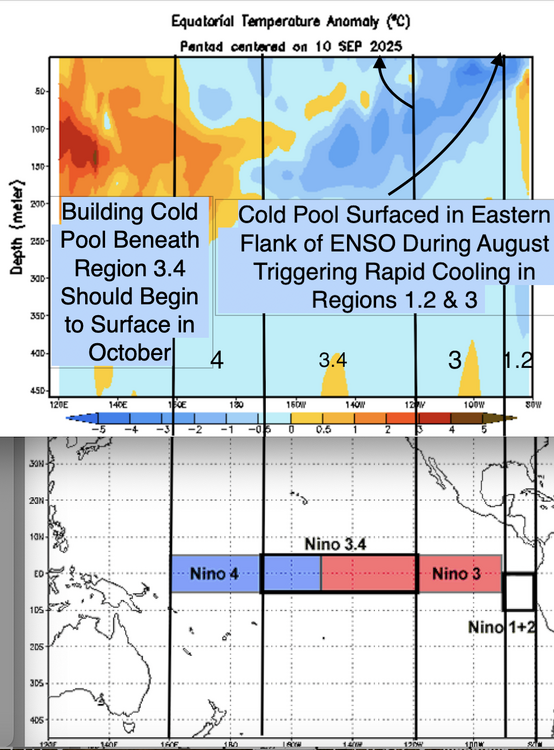
Yes, I think Jerry is focusing on region 3...while 1.2 is volatile....this marked cooling in that zone isn't a function of volatility. If you have been paying attention, the subsurface cold pool emerged due to sustained trades.
-
No; it invalidates it. The eastern zone of 1.2 began warm and the subsurface cold pool emerged there.
-
There’s definitely a big jump between the 2. Losing the 70s and 80s really extends the growing season. But there’s some lousy COOP sites in there that result in polka dots.
-
The bottom one just looks like a higher-resolution version of the top map.
-
Wow, what an impressive heat lightning show to my southeast! This comes after some afternoon storms earlier today. I will try to get some lightning shots.
- Today
-
What, are you telling me that the eastern shore doesn't get its first frost at the same time as far northern Maine?
-
Finally seeing some colder air making its way into the US and eventually SE by the first and second weeks of October. https://www.pivotalweather.com/model.php?p=sfct_anom-imp
-
heh i’d be a little bit leery of using that comparison because there’s clearly a resolution change there I.e., the bottom panel has perhaps multiple factors of greater sampling density… suggestive by the granularity
-
Today’s Euro Weeklies release fwiw is more active, especially in the S Gulf to NW Caribbean and including S and C FL, and is suggesting that a well above normal 50+ Oct-Nov ACE is a realistic possibility. I’ll continue to follow the EW trends.
-

September 2025 OBS-Discussion centered NYC subforum
Stormlover74 replied to wdrag's topic in New York City Metro
59 already -
Welcome! So where you are in the forum will make a difference in what people will suggest. There is so much TO do. The Ap trail isn't that far off, plenty of other trails, from steep mountains to the canal (which includes biking). Course tons of museums and the Atlantic and bay are close by. It really depends on what you like to do. I am WAY off in the western zone of forum, but plenty out this way too. Trains (both museums and rides), trails, lakes, caves and more. Again welcome!
- Yesterday
-
I overseeded on Friday. Then it rained on Sat (0.26) and last evening (0.74), so win! Course I am a touch cooler than the coastal plain area. Went 'tree peeping' today thru my county into Greenbrier county in WV, about 50% color above 2500 foot, 25-33% down lower. Maples, poplars, dogwoods, cherry and locusts changing, oaks mostly still green.
-

2025 Atlantic Hurricane Season
Wannabehippie replied to BarryStantonGBP's topic in Tropical Headquarters
The wave behind gabrielle, the lemon on NHC site, looks like it would take a track further south and west of Gabrielle. The orange system, looks like it would track along where gabrielle has been. Still a lot of dry air out there in the Atlantic as well. -
Lemon now 10/30 Mandarin now 10/60
-

2025 Atlantic Hurricane Season
Michelle Davies replied to BarryStantonGBP's topic in Tropical Headquarters
Good lord. Mandarin is now 10/60. Lemon is now 10/30. -
Cheers for sharing all the stats, legends. Still wrapping my head around the temp swings here, I’m used to measuring storms in mm of rain and heatwaves (I'm originally from Gold Coast), not inches of snow! The Euro reckons it’s gonna bucket down midweek should I be worried or is that just classic model hype?
-
I see 4-5 days of rain on extended but I'm far too snake bitten by rain chances on extended forecast to invest hope into it. 4-5 days of an east wind is always welcome though. Sent from my SM-X210 using Tapatalk
-
2025 Atlantic Hurricane Season
Michelle Davies replied to BarryStantonGBP's topic in Tropical Headquarters
I'm seeing the Euro and the Google models develop the mandarin into a potent hurricane. I wonder if the lemon and mandarin could possibly merge. What are your thoughts? -

2025 Atlantic Hurricane Season
WxWatcher007 replied to BarryStantonGBP's topic in Tropical Headquarters
Model noise most likely. Most ensembles have nothing there with the focus on the SW Atlantic over the next week to ten days. -
Has anyone seen the 18z GFS slabbering NE?


