All Activity
- Past hour
-

Central PA Spring 2026 Discussion/Obs Thread
Itstrainingtime replied to Voyager's topic in Upstate New York/Pennsylvania
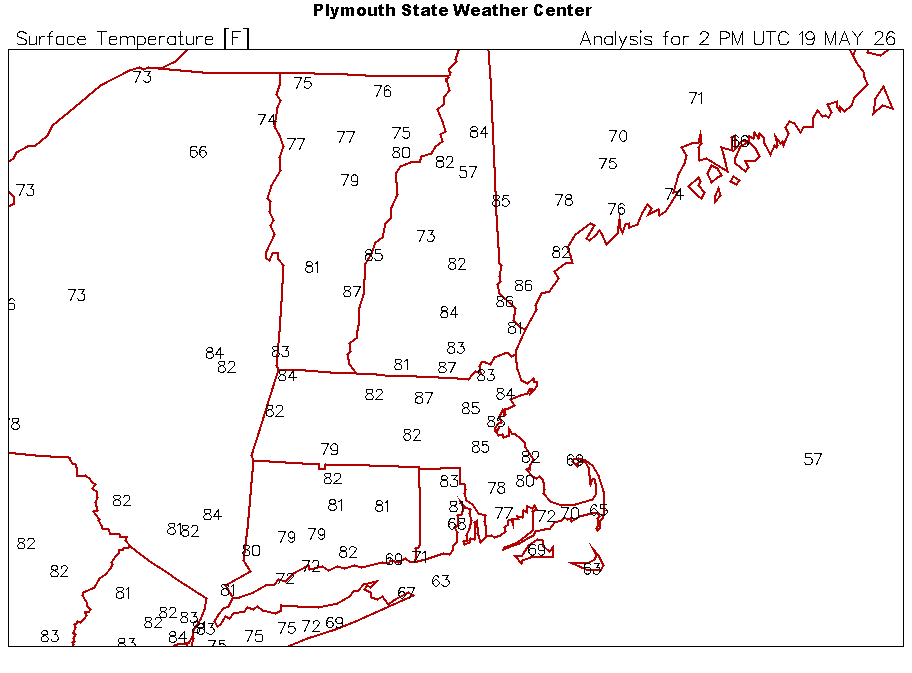
It's 88 degrees at 10:30 in the morning. Sorry to my hot weather friends but this is ridiculous. (to me) -
yup...north today, south tomorrow. damn. NAM came back down to Earth too with the mlvl lapse rates...had a feeling it was a bit too aggressive with the steeper lapse rates. DCAPE not bad though...probably see some scattered wind damage reports tomorrow along that swath you mentioned
-
86/73. Dews maybe a bit high on the Davis but it’s muggy.
-
Tomorrow is a South Coast day. Probably like a BDR-PVD-PYM on south.
-
Man this is great stuff. Look how excited everyone is.
-
Not too mention the BL flow becoming a bit more westerly...which may be related more to a faster FROPA. Looks like better convergence towards the south coast
-

2026-2027 Strong/Super El Nino
LakePaste25 replied to Stormchaserchuck1's topic in Weather Forecasting and Discussion
hopefully this pre nino summer is a bust and we set multiple heat records throughout the summer. I love hot and humid summers -

Central PA Spring 2026 Discussion/Obs Thread
NepaJames8602 replied to Voyager's topic in Upstate New York/Pennsylvania
Already looking forward to this weekends cool down, when you can actually go outside and not melt. Hopefully we get some good rains! -
83.0° The usual S-SW downslope spots are torching. North of the whites and NE of ORH hills
-
I thought the other day the models were too liberal with theta-e advection/pooling N/E of NYC just because the the antecedence has been a bit of a dry anomaly. Not sure if that'll be the case ...buuut, right turning clusters Pacman gobbling CAPE toward the source seems like an option in this synopsis, either way.
-

Central PA Spring 2026 Discussion/Obs Thread
pawatch replied to Voyager's topic in Upstate New York/Pennsylvania
I had one storm go to the south and the to the north, Trout Run area. It split…. -
3km is a shutout tomorrow and the HRRR has development from eastern PA moving across NJ, southern CT, and southern RI lol. 3km probably ran using Breslow's algorithm
-
Running a bit behind here, 83 and flow is more light S.
-

2026-2027 Strong/Super El Nino
forkyfork replied to Stormchaserchuck1's topic in Weather Forecasting and Discussion
so let's talk about what's actually happening now -

2026-2027 Strong/Super El Nino
MJO812 replied to Stormchaserchuck1's topic in Weather Forecasting and Discussion
Models were took quick with the insane El Nino ?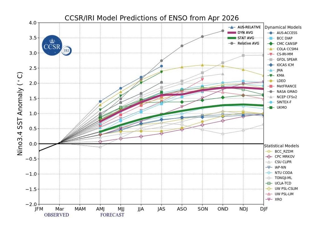
-

2026-2027 Strong/Super El Nino
roardog replied to Stormchaserchuck1's topic in Weather Forecasting and Discussion
On top of that, a model forecast for a strong +IOD in late summer and fall isn’t exactly a sure bet. -
Currently 87F here. DP 67%, RH 60 as of 10AM.
-

E PA/NJ/DE Spring 2026 Obs/Discussion
The Iceman replied to PhiEaglesfan712's topic in Philadelphia Region
I think someone in the area hits 100 today. My forecast point and click jumped to a high of 99. All time May high temp is 97F for PHL, KRDG, KABE and 99F for TTN, ILG, and KACY. The daily hi records for today might be broken at every single station in the CWA. -
BML had a low of 47° and went from 53° to 84° in 3 hours.
-
3km liking southern VT/NH into northern ORH County today
-
Yeah I swear every 10 mins when I refresh my station it’s up another degree. 81.1° and there’s still soggy spots in the yard. 10am ASH and FIT gone wild
-

2026-2027 Strong/Super El Nino
40/70 Benchmark replied to Stormchaserchuck1's topic in Weather Forecasting and Discussion
This is what I was driving at.....the very strong +IOD didn't prevent the La Nino in 2023, so how can we be confident that it will this year.... -
It has happened before. Highest temp in May (maybe even April for someone on here one year?)
-
I was thinking that might be the case for me
-
2026-2027 Strong/Super El Nino
40/70 Benchmark replied to Stormchaserchuck1's topic in Weather Forecasting and Discussion
Well, you could do that with any period....add March in and winter wasn't that cold.


