All Activity
- Past hour
-
Nothing for me to watch on radar anyway. Dry as a bone with peeks of sun. No significant rain since July 1-2
-

2025-2026 ENSO
40/70 Benchmark replied to 40/70 Benchmark's topic in Weather Forecasting and Discussion
Okay, I absolutely agree with this. The is in sync with my observation about how dialectical seasonal forecasting has become. -

2025-2026 ENSO
donsutherland1 replied to 40/70 Benchmark's topic in Weather Forecasting and Discussion
I agree. I don't think it's non-viable. I just don't think it's the slam dunk some are making it out to be. -
2025-2026 ENSO
40/70 Benchmark replied to 40/70 Benchmark's topic in Weather Forecasting and Discussion
Solar max and QBO east seasons aren't exactly void of blocking potential, either. Research by Gray et al, 2004 elaborates on the complex relationship between the solar cycle and the QBO phase. Integrating Solar & QBO Research for a Comprehensive Polar Forecast The aforementioned Holton-Tan relationship, which dictates that an easterly QBO is correlated with both a greater incidence of, and an earlier development of SSW, becomes more complicated when considering the solar cycle. In some cases, when the QBO and solar cycle are in conflict, they can either over ride one another or even cancel each other out (Gray et al 2004). Here is a list of combinations and the theorized relationships for clarity. Solar min/W QBO: This is entirely consistent with the Holton-Tan relationship in that the westerly QBO essentially "wins". The PV is likely to be stronger than average until the final warming in spring. Solar max/W QBO: In this case, the Holton-Tan relationship is applicable early on in the season, as major warmings are unlikely. However, the Holton-Tan relationship reverses mid winter and the latter portion of the season from February onward is susceptible to warmings and major PV disruption. Winter 2024-2025 was a textbook example of this. Solar Min/E QBO: There are no inconsistencies here, as the entire season is more prone to polar vortex disruptions and SSW as per the Holton-Tan relationship. Solar Max/E QBO (2025-2026): The Holton-Tan relationship applies early on given that PV disruptions are likely in December, before the relationship reverses and they are less likely later in the season -
September 2025 OBS-Discussion centered NYC subforum
donsutherland1 replied to wdrag's topic in New York City Metro
Belmar and perhaps Staten Island could see an inch. I think amounts will be less on Long Island, though. -
Tropical Storm gusts are being reported along the NJ and DE coast
-

September 2025 OBS-Discussion centered NYC subforum
anthonymm replied to wdrag's topic in New York City Metro
Wow I really hope we don't torch the last several days of the month. I need to be outside all day and I'd rather not sweat my a*s off in mid 80s temps. -
2025-2026 ENSO
40/70 Benchmark replied to 40/70 Benchmark's topic in Weather Forecasting and Discussion
What I mean is there is more than one avenue to a similar sensible weather outcome......ie, just because SST patterns are differetn doesn't necessarily preclude an analog seasons from ultimately being a valid analog in terms of sensible weather. All this proves is that 2013-2014 is not an ostenisbly viable N PAC analog, however, that does not necessarily mean that the coming season won't have some similarities. I think there is plenty of support for poleward ridging, regardless. -
Looks like the Nina is minoring out. Also, negative anomalies are no longer east based. Hard to tell but this appears to be the trend over the past few weeks. Gun to head I’d hedge normal in temperatures and snow for the winter. For a lot of sne, that’s going to feel snowy since the past few winters have been paltry snow wise.
-
2025-2026 ENSO
donsutherland1 replied to 40/70 Benchmark's topic in Weather Forecasting and Discussion
I haven't looked closely at all the details at this time given how much can change. It is a better North Pacific match than 2013-14, at least right now. It wasn't a bad winter, either. -
September 2025 OBS-Discussion centered NYC subforum
donsutherland1 replied to wdrag's topic in New York City Metro
Coastal low is a broad term for the system. Nor'easters are coastal lows. -

2025-2026 ENSO
PhiEaglesfan712 replied to 40/70 Benchmark's topic in Weather Forecasting and Discussion
2020-21 is my next best analog after 1949-50. I like it because it's more recent, but I the one thing working against it is that 20-21 was near a solar min, and we're now near a solar max. -

September 2025 OBS-Discussion centered NYC subforum
Brian5671 replied to wdrag's topic in New York City Metro
Breezy, mostly cloudy and 73 here...will be a close call to get any rain here-12z runs are right on the edge. LI/NYC and most of Jersey do ok. -

September 2025 OBS-Discussion centered NYC subforum
bluewave replied to wdrag's topic in New York City Metro
The only posts I have deleted contain specific model forecast charts which can become outdated after only 1 run at times. I don’t like leaving inaccurate model information up when there is newer information available. But I never delete my forecast ideas which you can always go back and find in all the threads. -
heh, imagine if this solution turned out warm biased, huh
-

September 2025 OBS-Discussion centered NYC subforum
uofmiami replied to wdrag's topic in New York City Metro
I do, I busted horribly back in fall of last year calling for a cooler November, as I recall. It's called forecasting, you'll never be correct all the time in weather. I just don't delete my posts when the forecast of it ends up incorrect. -

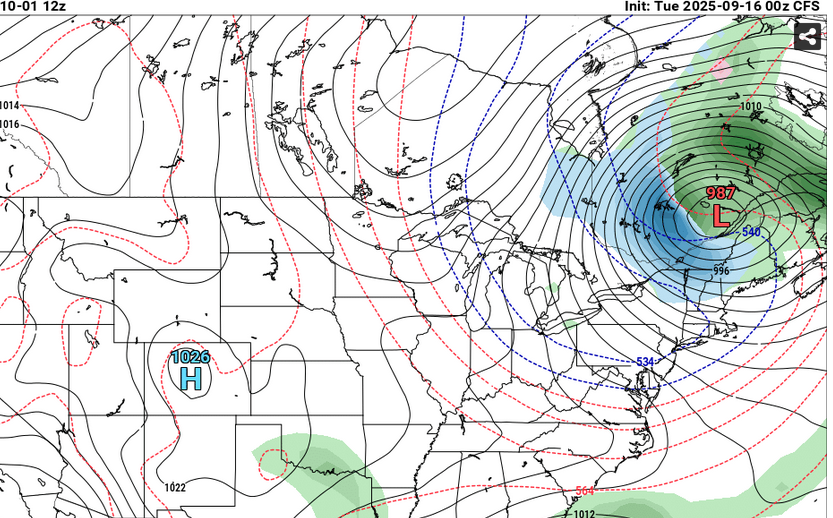
Invest 92L--90% two day, 90% five day odds
GaWx replied to WxWatcher007's topic in Tropical Headquarters
12Z UKMET: center passes just SE of Bermuda NEW TROPICAL CYCLONE FORECAST TO DEVELOP AFTER 36 HOURS FORECAST POSITION AT T+ 36 : 19.4N 49.2W LEAD CENTRAL MAXIMUM WIND VERIFYING TIME TIME POSITION PRESSURE (MB) SPEED (KNOTS) -------------- ---- -------- ------------- ------------- 0000UTC 18.09.2025 36 19.4N 49.2W 1008 42 1200UTC 18.09.2025 48 20.2N 51.3W 1007 37 0000UTC 19.09.2025 60 21.1N 53.9W 1007 33 1200UTC 19.09.2025 72 21.6N 56.5W 1008 28 0000UTC 20.09.2025 84 22.8N 58.1W 1008 31 1200UTC 20.09.2025 96 24.1N 59.6W 1009 30 0000UTC 21.09.2025 108 25.8N 59.8W 1008 37 1200UTC 21.09.2025 120 27.3N 61.2W 1005 46 0000UTC 22.09.2025 132 28.8N 62.3W 1003 44 1200UTC 22.09.2025 144 30.3N 63.0W 1001 44 0000UTC 23.09.2025 156 31.7N 63.0W 1000 49 1200UTC 23.09.2025 168 32.5N 61.5W 998 43 -
2025-2026 ENSO
donsutherland1 replied to 40/70 Benchmark's topic in Weather Forecasting and Discussion
I'm not expecting perfection. But I think boundary conditions, particularly SSTAs are probably the most important variables. The area of warmest Winter 2013-14 North Pacific SSTAs are not a great match with what currently exists. At present, Winter 2020-21 is a better North Pacific Match (again not perfect, but better).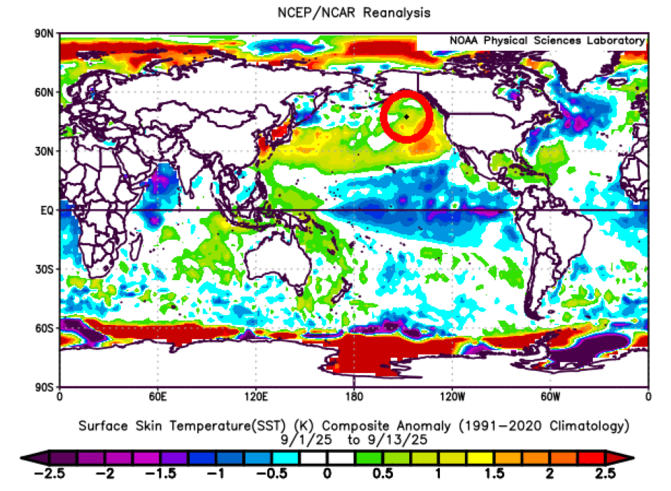
-
Good discussions all! Unlike like the last couple of runs, the 12Z UKMET has no followup TC to 92L.
-
2025-2026 ENSO
PhiEaglesfan712 replied to 40/70 Benchmark's topic in Weather Forecasting and Discussion
I'm hoping we stay ENSO neutral. Second-year ENSO neutrals tend to do well. A warmer version of 1993-94 and 2013-14 could be possible. -

Occasional Thoughts on Climate Change
Typhoon Tip replied to donsutherland1's topic in Climate Change
Boil them frogs, boy -
Humans can't play the long game. We aren't hardwired for it. We'll always be reactive and not proactive. That's why CC is the perfect end for us. It's slow, subtle, and not overly alarming(at first). We won't know we are in serious trouble until it's too late to do anything about it. We probably have already crossed that inflection point. We just scratchin the surface of our good times. Thank god we have social media to distract us as we decline. Phew..
-
I like this Larry, we have one for ENSO so we should also have one for AMO.
-
Out of Service Until Further Notice.
-

September 2025 General Discussion
TheClimateChanger replied to Geoboy645's topic in Lakes/Ohio Valley
Benign weather persists across the region. With another dry day in the offing, Akron will have seen just 0.29" of rain over the past 47 days (August 1 to September 16). August was the driest month on record at Akron with just 0.19" of rainfall. Note - not just the driest August, but driest of any month. Through today, only another 0.10" of rain has been measured in the month of September. This is the driest 47 day stretch on record. The prior record was 0.34" ending on November 17, 1924, but persisting for an additional 4 days [reaching a total of 51 days with just 0.34"]. In addition, a 47-day period ending on July 9, 1988, measured just 0.37" of rain. While a 47-day period ending on October 29, 1963, measured just 0.43" with that tally holding for an additional day. The next chance for rain occurs on Sunday, suggesting the current tally should hold through at least 51 days.


