All Activity
- Past hour
-
I know it is not the Helne in the Mountains severity But I lived in the Triangle during Fran-and it took me a LOT of years to not freak out when we had strong wing gusts the dern trees falling...........
-
Sitting in the front of the house and occasionally seeing lightning off to the East.
-
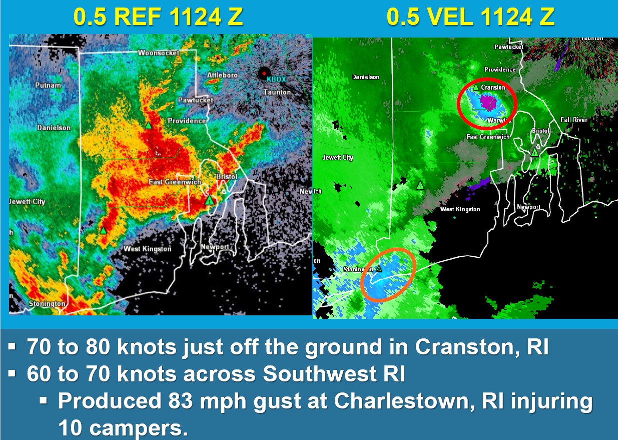
Lots of beneficial rain falling on the parched areas of Block Island Sound right now lol. Hopefully it comes north a little. Rain has been getting shredded on potholes in RI as of late…
-
It’s been pouring here for most of the past 90 minutes. Not much thunder/lightning except for the initial storm that came through around 8:30.
-
got about .40 here-alot of lightning and briefly heavy rain but nothing severe.
-
you have 177,000 posts here--when was the last time you actually logged off? LOL
-
Cells popping to the south as well.
-
An active night especially around I26 in Buncombe and Madison County.
-
https://easternmassweather.blogspot.com/2026/05/development-of-major-el-nino-imminent.html
-
I’ve been waiting to hear! Congratulations!!
-
I don't think that these are surfaced-based storms. The low, rolling thunder suggests an inversion, and elevated cape makes sense given the overnight height falls.
-

2026-2027 Strong/Super El Nino
40/70 Benchmark replied to Stormchaserchuck1's topic in Weather Forecasting and Discussion
https://easternmassweather.blogspot.com/2026/05/development-of-major-el-nino-imminent.html -
Scott likes "S Coast specials" esp.the AM one on Aug 4, 2015 in RI!

-
I think that outflow boundary stalled our just west of I-95 in Maryland. It may be enough to organize what litter instability is left.
-
Sunday. We in Vegas now. Was a great wedding.

-
Yes, Rochester/Dover to Hampton do quite well. I have a couple of pix from the May 21, 2006 tornado (not mine) that show it very well. I'll post them once I get home tomorrow morning. Hampton Beach is the site of a significant tornado in 1898! NH JUL 4, 1898 1530 3k 120inj 100y 1.0m F1 ROCKINGHAM - Tracked southeast across Hampton Beach. Three fatalities by falling timbers at a skating rink where over 100 people had taken shelter from the thunderstorm. 20 cottages were destroyed. CoastalWx benefits from enhanced tstm activity in Weymouth, but for a different reason. The convergence of the S and E coast sea breezes gives him a bump. You can actually see a weak local total lightning bulls-eye from climo over his area!
-
Yeah, I'm about 100 feet higher at new location, a little north and west of you. Basically where 70, 270 and 15/340 meet. Like 410' vs 325' over off English Muffin. I think bigger thing is I'm closer to the Catoctin Ridge, which might have me in a little rain shadow for some events.
-
Most/all rain sitting just north of silver spring since the 4pm hour. We got some showers then. Didn't amount to much. But just a few miles away looks soaked
-
Thundered a few times tonight but no rain so far.
-
We toughed it out with window fans. I’ll put the ACs in when a prolonged heat stretch looks imminent.
-
Buncombe NC-Haywood NC- 855 PM EDT Wed May 20 2026 ...A STRONG THUNDERSTORM WILL IMPACT SOUTHEASTERN HAYWOOD AND SOUTHWESTERN BUNCOMBE COUNTIES THROUGH 930 PM EDT... At 855 PM EDT, Doppler radar was tracking a strong thunderstorm near Waynesville, moving northeast at 15 mph. HAZARD...Wind gusts up to 40 mph and pea size hail. SOURCE...Radar indicated. IMPACT...Gusty winds could knock down tree limbs and blow around unsecured objects. Minor hail damage to outdoor objects is possible.
- Today
-
Still have 1000+ CAPE for the immediate suburbs to help wring out the now moist atmosphere. As long as we can buy some forcing we should be able to rain. Hopefully the front sags south to help out the people who got skunked earlier.
-
Same, hopefully the stuff down by Culpepper gets to me.
-
Looking at WXUnderground your station is directly North of mine. If I remember correctly that you moved off of Jefferson Pike. Will be interesting to see the difference between the elevations.
-
South Haywood fixing to get smacked.