All Activity
- Past hour
-
As an outsider who follows the Raves but with no rooting interest one way or another I rate the coaching in between most others. I was never as high on it a few years ago when almost everyone considered the Ravens staff one of the very best in the NFL, and I am not as down on it now. The team is devastated by injuries in key spots. I'm not sure anyone could overcome that, especially in a league that features as much parity as the NFL does, when a few key players separate the best and worst teams. Look at the Eagles...they got hit by some injuries to weak spots in their roster and they suddenly look like crap the last couple of weeks. Take away 3 or 4 key players and they aren't nearly as good a team anymore. The Ravens have been hit even worse! My opinion of the inability of the team to win a super bowl with their recent stacked roster is its 90% on the QB. Lamar has been perhaps the best regular season QB in NFL history. But his playoff performance has been below average. Last year he was better, but before last year his playoff QB rating was BELOW 80!!! You can't win with that. That is below even a "game manager" QB level of competency. One season he was injured in the playoffs and that had nothing to do with him. And last year he was better and perhaps in another parrallell reality they do win the SB last year...but the receiver drops that easy catch at the end...and who knows. He played well enough to win and that one time someone else let him down...and maybe the Ravens don't have the same mental block the Bills do against KC and they don't fail to convert a 3rd or 4th and 1 like 27 times and they win the AFC championship last year. Dunno about beating the Eagles...they were a freaking freight train at the end of last season...but who knows. But that was one game...if Lamar played like he does in the regular season in the playoffs across the board the last 7 years...they probably would have won a super bowl and that has nothing to do with coaching.
-
What adds more interest to this IMO is it seems a lot of "correlations" we had been very familiar with have diminished over the past decade-plus as well. Now, the easy answer here is that is just a product of increasing our sample size (data set). This is likely certainly a factor, but how strong of a factor? But I suspect something else is going on too...and the way to come to that conclusion is when you break everything down into how we understand things and basic principles and you're getting results that don't make sense. also, if I understand correctly, the correlation is geared more towards the evolution of the AO? Lots of influences on the state and evolution of the AO, especially stratospheric processes.
-

Spooky Season (October Disco Thread)
40/70 Benchmark replied to Prismshine Productions's topic in New England
Absolutely...I equate it to squats in weightlifting.....it's the goliath of lifts, but it's so dependent upon balance, stability and mobility....all of these minute details that are requisite for the unleashing of such fury. -

Spooky Season (October Disco Thread)
CoastalWx replied to Prismshine Productions's topic in New England
Hurricanes for being so powerful, are so prone to small factors that influence their intensity. Fascinating when you think of it. -

Central PA Fall Discussions and Obs
canderson replied to ChescoWx's topic in Upstate New York/Pennsylvania
Strong winds this am - blowing into the 30s. -
Frontal passage Sunday evening looks impressive.
-
Spooky Season (October Disco Thread)
40/70 Benchmark replied to Prismshine Productions's topic in New England
Kind of analagous to how warmer temps do not equate to smaller snow storms, unless you live....here, apparantly lol. But these frontier concepts get oversimplified. -
It depends what is meant by the bold ( for me - ) Snow advances ... that's just seasonally unavoidable. But, not all years observe this normalcy the same way. They all tend ( or used to before perhaps 25 years ago), end up around the same cryospheric state by mid Februaries ... but the autumnal d(cryo)/dt (speed of recovery) I have found is more correlated to ensuing winter temperature biases over Canada ( and by circumstance of proximity ... affecting the U.S.) Faster tended to be colder Mt-WI-NY-NS Slower tended to be more variable .. ( don't wanna say "warm" here because that word is very relative circa Jan 25th at Tower Minnesota) So stating the obvious... cold is intrinsic to snow. Gee ya think- But what's interesting about this is that the correlation has been not as good over the last decade ... It's complex, but I suspect the warming polar summer states are setting up favorable frameworks more abruptly during recovery times - going for deeper lows to any snow at all... so it's artificially ( so to speak...) lending to impressive d(cryo)/dt. ... Like everything being effected by the CC one-eyed monster, the predictability of any domain in question tends to be the first aspects to get f'ed. So the simplest version of all this, yes the d(cryo)/dt is impressive, this year, but - for me - it could be construed as more impressive in say, 1995 than it really is in 2025. *But* ( ... to add even more to this "popcycle" headache - ), it's not just the land snow. I noticed, back mid to late August that that the rate of sea-ice loss was slowing more so than the last several years, relative to dates... That was unexpected, particularly when we just came off the 2023 oceanic jacuzzi historic year so recently. Interesting... Anyway, the seasonal nadir appeared to also happen about 10 days to 2 weeks earlier than the last several years ( using Climate Reanalyzer), and has shown also that seasonal recovery behaves to do so more meaningfully, sooner and perhaps faster. This below is an example of how the scalar value, still being low, belies the character/behavior of the system, which is perhaps better exposed by evaluating the deltas. So adding all this to the other aspects farther above ... mmm, I'm at least curious if the wholesale hemisphere is hinting here.
-

Spooky Season (October Disco Thread)
UnitedWx replied to Prismshine Productions's topic in New England
I'm heading to an event in Hilliard Ohio tomorrow morning. I'll be taking RT 80 through PA, and hoping to see some good color along the way. -
The upper level low to the NW of the STJ wave acted as a suppressive feature instead of phasing in any way. The upper low acted more like a TPV instead of a typical upper low in the end. That was one of the biggest mistakes I made the week leading up to that, "as the upper levels trended better the surface was worse" I kept saying, but I was not correctly seeing, and I think @Bob Chill was the first to identify, the upper low was actually the problem not a solution. Typically an upper low tracking just to our NW would indicate a surface track maybe even too far NW for what we want, not suppressed, but not if that upper low acts like a polar vortex, and squashes everything around it instead of interacting with it. If you are asking why it did that though I don't know. But there must be something about a Nina though because there are a lot of examples of storms that hit that area (immediate coast from NC/VA Beach up the Delmarva) in Nina's. My best guess is it's a matter of the energy balance between the northern stream and the southern stream. You have a strong enough STJ wave and it can bully its way without much NS help. You get a balance between the two and you can get a phased event where the NS phases with a STJ wave and get a storm that way. But if the balance of energy is too skewed towards the NS, it acts as a suppressive force and squashes everything. This is our biggest issue with Ninas. We are too far south to typically get a lot of snow from NS dominant waves. We can get some, a clipper, a NS wave that tracks further south than usual, but they aren't going to be huge snowstorms here, they can amplify along the east coast and get places further to our north with a bigger event...but were too far southwest typically to get a big storm that way. And if the NS acts as a suppressive force we end up too far north for the weaker STJ waves you get in a nina. So we end up in between. That is why the mean snow minimum for ninas is centered right over us. The odds of an above average snowfall season go up to our north and south.
-
I've had 2 50" seasons since 2016 (the magic year), 17/18 (53") and 20/21 (51", I'm 37 miles as the crow flies away, so pretty much the same exact climate. Our snow averages are different by 2"). With some very slight adjustments in storm track (probably less than 20 miles) NYC could have had upper 40s to low 50s in those seasons as well (they had 41" in 17/18 and 39" in 20/21). I think that is where "luck" comes into play (being the "winner" vs "loser" in snow cutoffs/being in the best banding) and not CC.
-
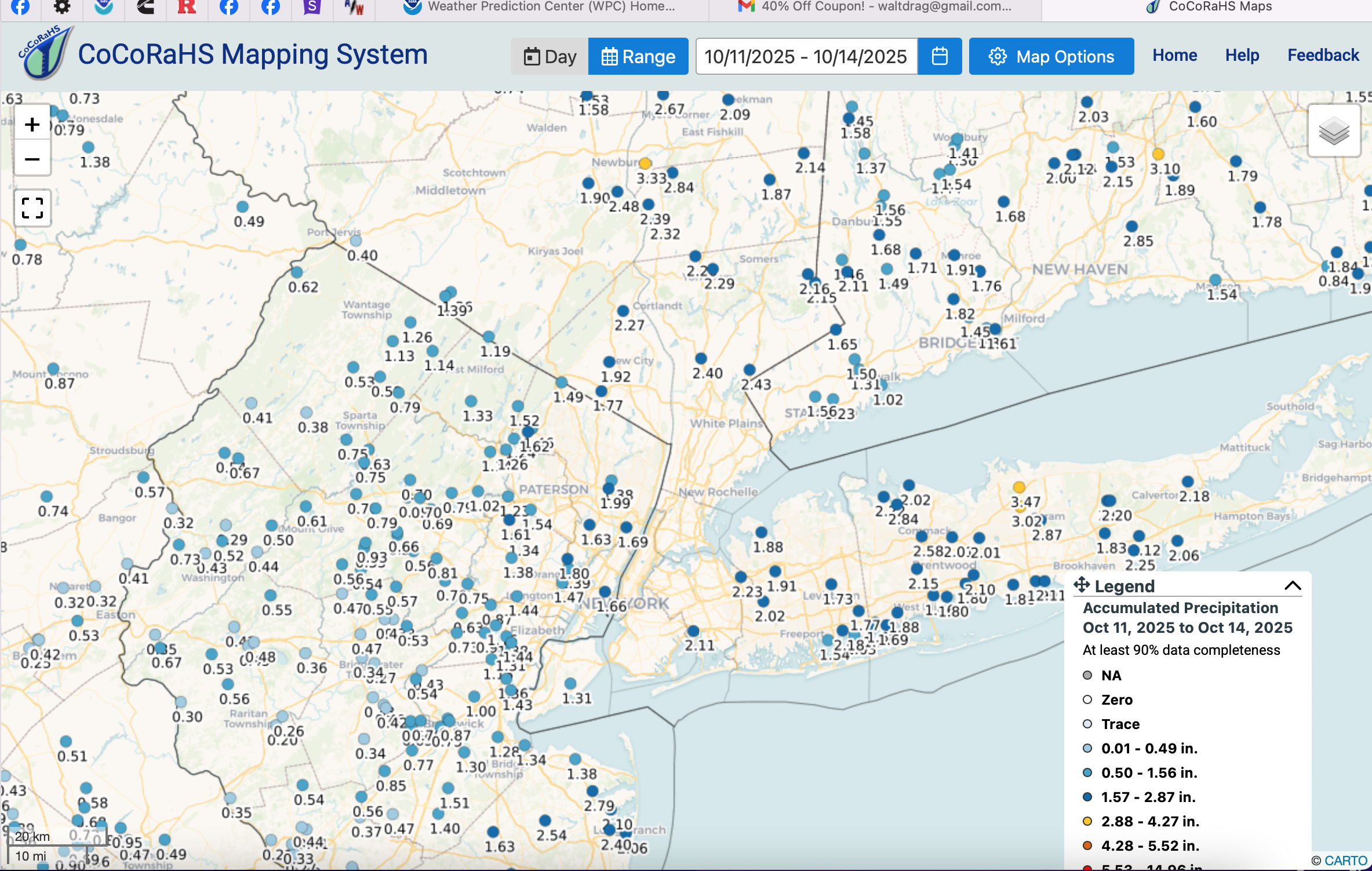
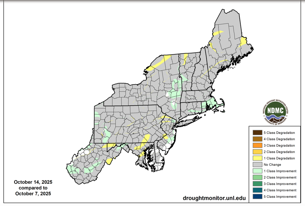
I could benefit from greater u understanding on what went into this lack of reclassifcation downward in NNJ. The yellow stripes e-w across NNJ? Did River flows influence, or local drought reports? Maybe someone can post the radar analysis or whatever went into the evaluation to support the drought monitor. This will help me curb my enthusiasm for expectation. Thank you.

-
Spooky Season (October Disco Thread)
CoastalWx replied to Prismshine Productions's topic in New England
Pretty sure I saw that mentioned somewhere too. Also goes to show you there's a lot we still need to learn. Warmer waters does not equate to more canes. There's a lot that goes into it. -
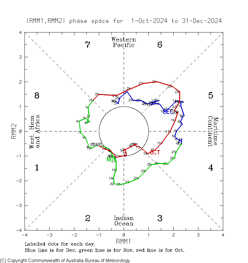
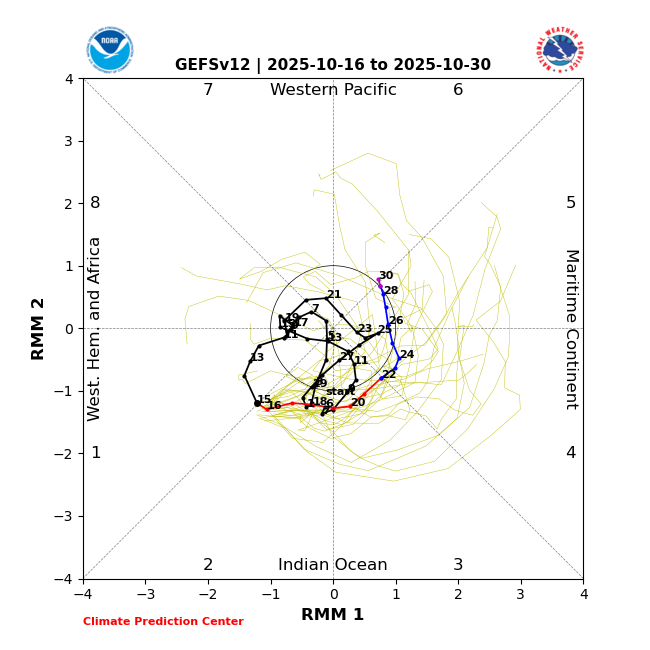
Not sure that the magnitude of this MJO pass is set in stone yet. There are many solutions depicting a stronger MJO pass and the models haven’t been exactly locked in on its strength.
-

Central PA Fall Discussions and Obs
Mount Joy Snowman replied to ChescoWx's topic in Upstate New York/Pennsylvania
Low of 39. Looks like the @Blizzard of 93 540 line makes an appearance over the Commonwealth next week. #WinterIsComing -
Same for me.
-

Spooky Season (October Disco Thread)
Torch Tiger replied to Prismshine Productions's topic in New England
I have that clipped on sound board lol. Won't let me upload here -
Yeah, weaker amplitude MJO through 4-6 than last year which was what I was expecting. The strong amplitude October MJO 4-6 years like 2024, 2020, and 2017 preceded the stronger +PNAs from December into January. The weaker years like 2022, 2021, and 2016 had a lower PNA. So this fits with my early thinking that this winter will be warmer than last year. But my guess is that there could still be some +PNA intervals but not to the extent of last winter. Snowfall is a bit more of a wild card. Since the snows were so low winter, it wouldn’t take much for an equal or better snowfall outcome. But that won’t be known until I see the December snowfall indicator. I am hoping that we can change up the dominant cutter,hugger,and suppressed Southern Stream storm tracks at least for a few weeks to maybe one month. That will probably be MJO dependent and not known until we get close to the time it starts showing up the medium range models.

-
Judoo?
-
BTW, this concept isn't, or shouldn't be unique to the SAI, either....it's pretty universally folly to base a seasonal outlook on any one factor...the more eclectic, exhaustive and multiperspective, the better-
-
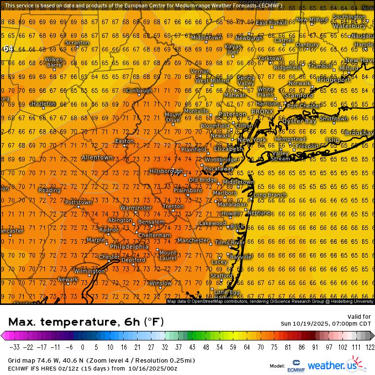
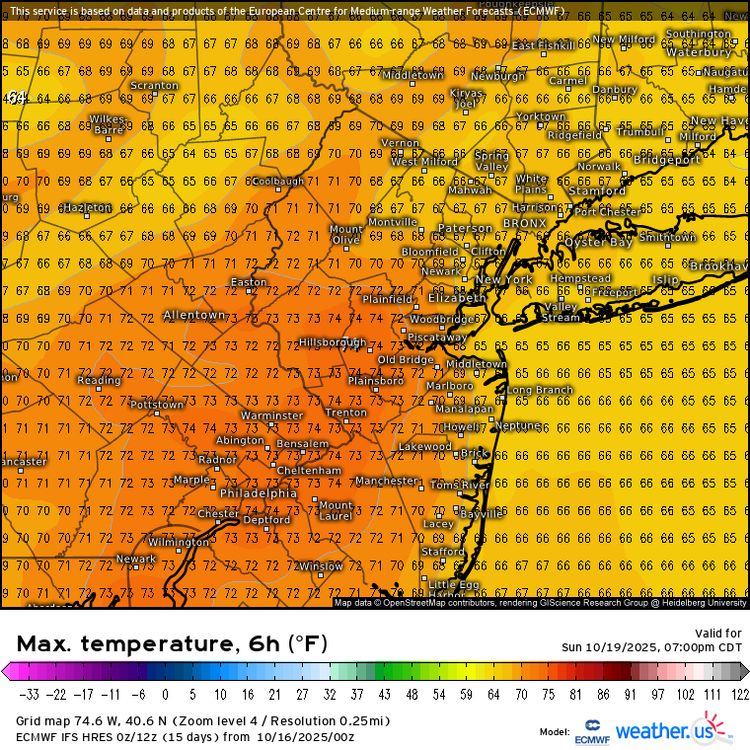
Yeah, JFK and several spots in NJ and Eastern PA made it to 70° on the offshore flow. Looks like areas in NJ will be favored for more 70s this weekend. But probably too much onshore flow at places like JFK. Data for October 15, 2025 through October 15, 2025 Click column heading to sort ascending, click again to sort descending. DE WILMINGTON AIRPORT WBAN 73 DE GEORGETOWN-DELAWARE COASTAL AIRPORT WBAN 72 PA PHILADELPHIA INTL AP WBAN 72 NJ ATLANTIC CITY INTL AP WBAN 72 NJ MILLVILLE MUNICIPAL AIRPORT WBAN 71 NJ SOUTH JERSEY REGIONAL AIRPORT WBAN 70 NJ SOMERSET AIRPORT WBAN 70 Data for October 15, 2025 through October 15, 2025 Click column heading to sort ascending, click again to sort descending. NJ NEWARK LIBERTY INTL AP WBAN 72 NJ TETERBORO AIRPORT WBAN 70 NY JFK INTERNATIONAL AIRPORT WBAN 70
-
Spooky Season (October Disco Thread)
40/70 Benchmark replied to Prismshine Productions's topic in New England
We need the "sick brag, bro" clip from WEEI -
45 degrees this morning feels great. Driving my kid to school, 13 years old logic,no hoodie or sweatshirt just t-shirt with 45 degree temps but wears either when it's 80 plus. Smh lol
-
Perfectly stated
-
I think the "fraudulent" claims are too far on the other end...like most elements of research concerning seasonal forecating, it's importance was initially overstated due to a combination of our lust for skill in this arena combined with today's overzealous portrayal on social media. It has it's value if used properly in concert with a multitude of other factors, but said value was undoubtedly intially overstated. I usually give it a shout out near the end of the polar section of my final outlook, but it's more of a confidence bolsterer/voice of dissent. It's not the basis of the forecast, nor should it be for anyone.