All Activity
- Today
-

White Christmas Miracle? December 23-24th
40/70 Benchmark replied to Baroclinic Zone's topic in New England
https://easternmassweather.blogspot.com/2025/12/white-christmas-likely-for-portion-of.html FIRST & FINAL WHITE XMAS CALL: -
Winter 2025-2026 Offers Return to Normalcy
40/70 Benchmark replied to 40/70 Benchmark's topic in New England
White Christmas Likely For Portion Of The Area Weak System Impact On Tuesday Synoptic Overview It now appears as though the possibility of a White Christmas has increased for at least a portion of the area, despite Friday's "Grinch" storm having scoured the region of any residual snowpack. This is due to a weak system that will break off of the Pacific energy out west during the day on Tuesday and subsequently slide to the east-southeast in the flow between the polar vortex and central US ridge. Although this energy will begin to amplify upon reaching the coast as it descends the eastern periphery of the ridge, it will do so too far to the east to produce a significant storm for the forecast area. Had this ridge been centered a at the longitude of Montana as opposed to Minnesota, far greater travel disruptions would be likely given that a faster rate of amplification would yield a much more significant storm further to the west, and closer to the coast. While that will not be the case, a period light snowfall will leave light accumulations across especially the interior. However, the track of the system will be to the north of the area prior to a full transfer to the coast, which will allow winds to switch to the south. This will eventually induce a transition to rainfall prior to precipitation ending Tuesday evening across much of the coastal plain, which will obviously affect which locales manage to observe a White Christmas (1" or greater of snow on the ground at 7am Christmas morning). Anticipated Storm Evolution Light Snow will begin overspread the western half of the area during Tuesday morning and reach all but the eastern third of the area by midday. The morning commute should be fine given the late start of the snowfall, meager intensity and the reduced volume of traffic given the holiday period, however, commuters in Connecticut may be wise to leave some extra time, especially southwestern areas. The south coast of Connecticut will have transitioned to rain b early evening, as the storm begins to intensify and the storm moves closer to peak across the area, which will slow a Tuesday afternoon commute that will likely already have a heavier volume owed to holiday traffic. The storm will begin to redevelop off of the coast by midnight into the early predawn hours of Christmas Eve, but not before precipitation ends as rain roughly inside of I 495. Snow and rain showers will taper off during the predawn hours on Christmas Eve, with the first light yielding a festive blanket of white across the interior, a barren, puddle-filled earth near the coast. Stay tuned for more information on what maybe a similar system on Boxing Day. FIRST & FINAL WHITE XMAS CALL: -
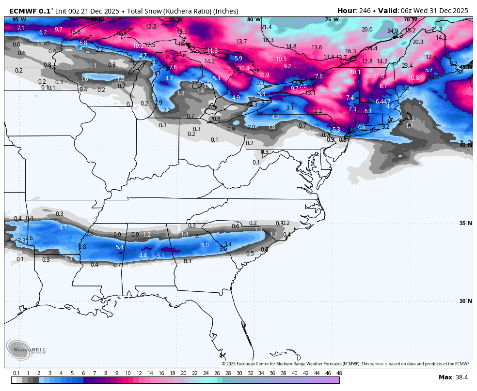
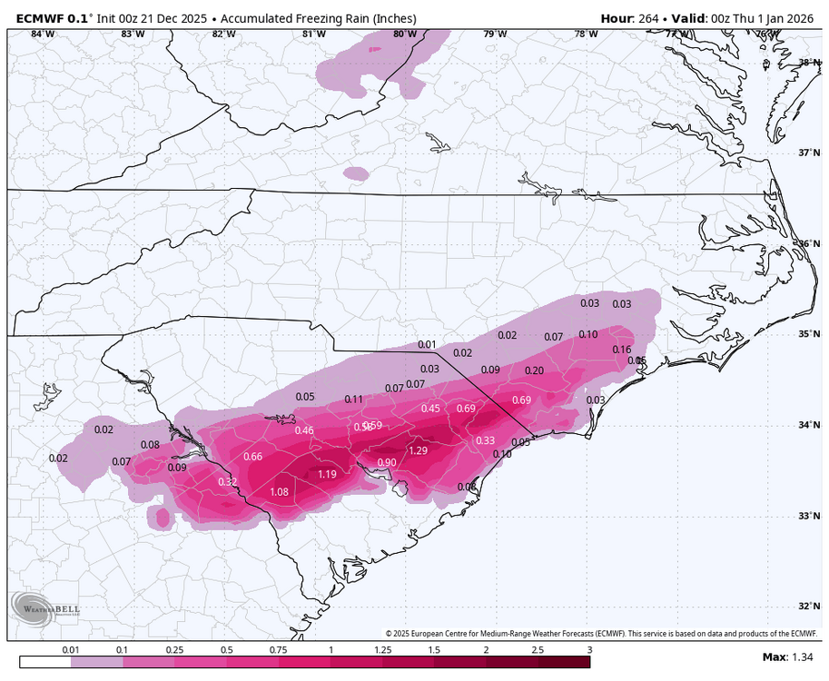
Don’t look at the 0Z Euro….or better yet look at it OMG! Many NC peeps won’t be thrilled but anyway: this is for 12/30 to early 12/31:

-
She on a mast cell stabilizer like Cromolyn (sp?) I use the OTC mast cell stabilizer eye drops for when my eyes get attacked, and it works superfast. Made with Ketotifen. Going to order the mast cell stabilizer nasal spray. I have lived off of Afrin for over 2 years. I'm thinking about peptide therapy. Maybe BPC-157, and there are a few others that could be helpful, can't remember their names off the top of my head. And I just read some research that creatine and glutathione can act as mast cell stabilizers
-
Guess we are on a break. Pretty epic start to winter however. It was cold. Saw some snow. I got nothin’
-
What the???

-
And not just snow storms. It's any storm.
-

Possible Light Snowfall (1" - 4") on Tuesday Dec 23
NEG NAO replied to Northof78's topic in New York City Metro
when you see something like this - it shows the models still haven't figured out how to handle this situation along with the NAM showing little or nothing . Need to get closer to get a better idea............ -
Gfs went south and euro went north and weak. Goodnight
-

Possible Light Snowfall (1" - 4") on Tuesday Dec 23
MJO812 replied to Northof78's topic in New York City Metro
Gfs went south and euro went north Goodnight -
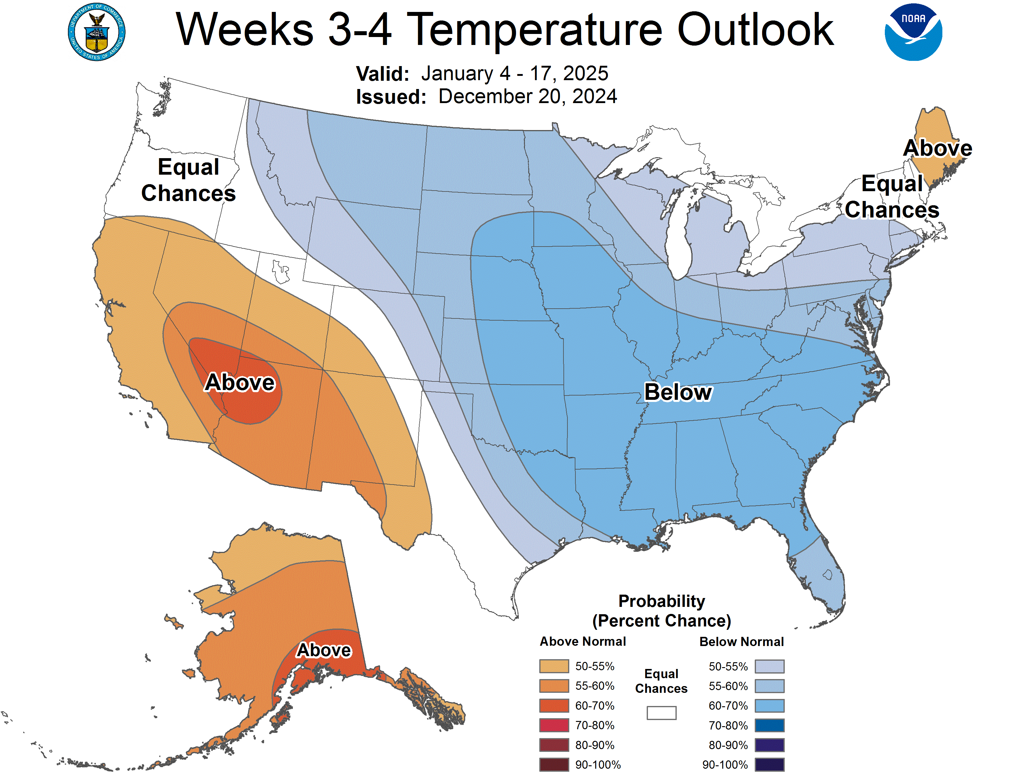
As I said, a year ago at this time the NOAA weeks 3-4 maps were quite cold looking (strongest cold signal in SE quadrant on record since this product started being issued) and they obviously verified quite well (although to be fair these aren’t actually forecasts): OTOH, 4 years ago at this time (when many E US posters’ tones on the wx boards were similarly gloomy) they were similarly mild looking to yesterday’s for much of the E US, which turned out to be “wrong”:

-

White Christmas Miracle? December 23-24th
WinterWolf replied to Baroclinic Zone's topic in New England
Agree. I have no idea what the hell he’s talking about…but whatever. -

White Christmas Miracle? December 23-24th
weathafella replied to Baroclinic Zone's topic in New England
It’s ok-you don’t have to send one to me… -
White Christmas Miracle? December 23-24th
WinterWolf replied to Baroclinic Zone's topic in New England
Got 2.5” on Sunday…I’m hoping for 1,5” more this go around. Just going by what that model showed. And I didn’t wear a vest pal? -

E PA/NJ/DE Winter 2025-26 Obs/Discussion
PhiEaglesfan712 replied to LVblizzard's topic in Philadelphia Region
The miracle White Christmas in 1998. Temperatures really torched that month, with 2 days in the 70s in the first week, and temps in the mid-60s as late as the morning of the 22nd. Then, temperatures fell throughout the day, leading to the snowstorm on December 23-24, 1998. -
White Christmas Miracle? December 23-24th
40/70 Benchmark replied to Baroclinic Zone's topic in New England
You get 4", and I'll send everyone on this forum a Xmas card with me wearing nothing but one of your skin tight vests with a turtle neck. -

White Christmas Miracle? December 23-24th
Torch Tiger replied to Baroclinic Zone's topic in New England
-
They’re still called Weeklies because that is based on their own extended maps being for one week at a time, not based on their release frequency. Today’s Euro Weeklies run/extended EPS mean was the warmest run yet this season for the E US overall. Today’s extended GEFS doesn’t look much better for the E US its entire run if you prefer cold (like I do). But obviously I’m hopeful they will bust badly! A year ago at this time, they were cold for the E US and NOAA’s weeks 3-4 products were about the coldest on record for the SE US. I was posting a lot about those outlooks as well as the cold Weeklies and was very excited. What a difference a year makes! They often have a decent clue as to the general upcoming pattern. But not always. So, we’ll see.
-
White Christmas Miracle? December 23-24th
WinterWolf replied to Baroclinic Zone's topic in New England
Thanks Steve…I’ll take my 4”. -

White Christmas Miracle? December 23-24th
Ginx snewx replied to Baroclinic Zone's topic in New England
.png.69659c861d930cf61f6bc8c8c551f2a4.png)
-

White Christmas Miracle? December 23-24th
CoastalWx replied to Baroclinic Zone's topic in New England
lol jsut saw. I’ll sell that. -
White Christmas Miracle? December 23-24th
CoastalWx replied to Baroclinic Zone's topic in New England
The inverted dong for you and I. Beware. -
White Christmas Miracle? December 23-24th
WinterWolf replied to Baroclinic Zone's topic in New England
Can you post bro. -
White Christmas Miracle? December 23-24th
WinterWolf replied to Baroclinic Zone's topic in New England
WTF are you talking about Bob? This is a f’n weather forum. I want to talk about weather. If T Blizz wants to keep being a negative fool…I have no time for that. If it sucks, fine. But if there are some positives, before verification, then it needs to be pointed out. I don’t come here for mental health…if you do, and he does, I’m sorry. -
White Christmas Miracle? December 23-24th
40/70 Benchmark replied to Baroclinic Zone's topic in New England
ICON looks pretty good up here.