All Activity
- Past hour
-

September 2025 OBS-Discussion centered NYC subforum
LibertyBell replied to wdrag's topic in New York City Metro
1994: A nor’easter wreaked havoc on coastal MD. 50-mph winds (gusts to 79 mph) destroyed 100’s of tents/vending areas at the end-of-summer Sunfest in Ocean City. Windblown fires burned several shops along the boardwalk; 9 foot waves flooded other areas. Damage up to $5 million. (Ref. Weather Guide Calendar with Phenomenal Weather Events 2011 Accord Pub. 2010, USA) I think I remember this-- did we have 5-5.50 inches of very heavy rainfall during this? I remember this because I was on I-80 in NJ when this happened. I also remember an August noreaster which gave us very heavy rain during the 90s. There was even some snow reported on Mt Washington in that one. -
Hope no one uninstalled
-
Yup, still cloudy here....12Z WB NBM thru Wed. Bring in rains tomorrow afternoon.

-
September 2025 OBS-Discussion centered NYC subforum
LibertyBell replied to wdrag's topic in New York City Metro
1978-79 was one of the coldest winters on record nationally, we might never see that kind of extensive cold ever again. -
Looks like it’s cloudier west of 95 on satellite. I’m assuming it thins out as milder air moves in.
-
Peak Season Forecast (Aug 20-Oct 20) Named Storms: 10 (2) Hurricanes: 6 (1) Major Hurricanes: 3 (1) Fernand, Gabrielle (MH) Thank you Gabby! More likely on the way.
-
September 2025 OBS-Discussion centered NYC subforum
LibertyBell replied to wdrag's topic in New York City Metro
Yeah and it's almost comical how quickly the changeover comes in. -
lol, I enjoy the seasons, but the older I get the less enthused I am about stratus clouds.
-
September 2025 OBS-Discussion centered NYC subforum
LibertyBell replied to wdrag's topic in New York City Metro
1995: A strong cold front pushed across the Midwest, bringing with it one of the earliest freezes on record. In Iowa, temperatures dipped to as low as 24° over the northwest and sub-freezing temperatures lasted nearly eight hours. Crop maturation was behind schedule so this freeze caused significant damage, with soybeans the hardest hit. About $195 million dollars worth of soybeans were lost. Drought had already taken its toll on the corn crop so the freeze did not aversely affect the corn too much.Chicago, IL experienced their earliest freeze on record as the mercury dipped to 32°. The low of 29° tied the record low for the month of September at Dodge City, KS. Further north, Jump River and Cashton, WI head their earliest measurable snowfall on record with 1.5 inches and 0.5 of an inch respectively. Other daily record lows included: Rapid City, SD: 19°, Bismarck, ND: 20°, Aberdeen, SD: 20°, Valentine, NE: 23°, Fargo, ND: 23°-Tied, Huron, SD: 24°, North Platte, NE: 24°, Scottsbluff, NE: 24°, Grand Island, NE: 25°, Sioux City, IA: 25°, Norfolk, NE: 26°, Lincoln, NE: 27°, Concordia, KS: 29°, Goodland, KS: 30°-Tied, Omaha, NE: 31°, Topeka, KS: 31°, Des Moines, IA: 31°, Kansas City, MO: 31 °F. (Ref. Additional Temperatures Listed On This Link) 1995-96 was showing its hand about how historic that winter was about to become.... JFK: 91 (1980) 1980's historic heat ended on a high note! -
Really took off. GREAT for my forecast lol.
-
September 2025 OBS-Discussion centered NYC subforum
LibertyBell replied to wdrag's topic in New York City Metro
it's been mostly sunny here today, very deep blue skies -
September 2025 OBS-Discussion centered NYC subforum
LibertyBell replied to wdrag's topic in New York City Metro
1980 was also one of our hottest summers and also extremely hot nationally. Which was the driest summer during the 1980s Don? -
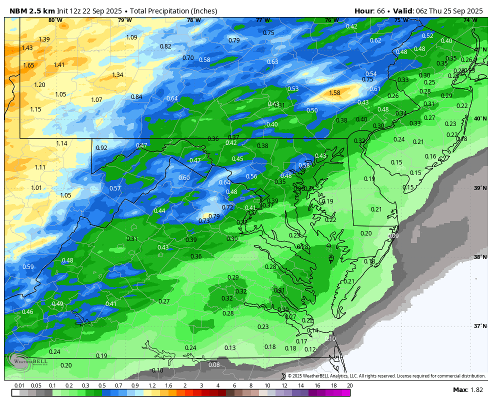
What looked like a slam dunk for 1-3 inches of rain now looks like less impressive and generally less than an inch. We'll take it but I was hoping for a good soaking
.thumb.png.07eb321d07a1ad131449941c93864fce.png)
-
 forkyfork changed their profile photo
 -

September 2025 OBS-Discussion centered NYC subforum
SACRUS replied to wdrag's topic in New York City Metro
Were some pokes of sun but now mostly cloudy -

September 2025 OBS-Discussion centered NYC subforum
steve392 replied to wdrag's topic in New York City Metro
As soon as the sun started ducking behind the tree's by me yesterday, temps started to drop enough to warrant a hoodie while being outside with the breeze. -

September 2025 OBS-Discussion centered NYC subforum
donsutherland1 replied to wdrag's topic in New York City Metro
No. The low at Mount Pocono was 48° as clouds moved in. Yes. For the Northeast it was the driest, but not for New York City. September 1, 1980-August 31, 1981 was the driest such period in New York City during the 1980s with 34.83" of rain. -
September 2025 OBS-Discussion centered NYC subforum
SACRUS replied to wdrag's topic in New York City Metro
Records: Highs: EWR: 94 (1970) NYC: 95 (1914) LGA: 93 (1970) JFK: 91 (1980) Lows: EWR: 44 (1997) NYC: 41 (1904) LGA: 47 (1962) JFK: 41 (1962) Historical: 1890 - A severe hailstorm struck Strawberry, AZ. Fives days after the storm hail still lay in drifts 12 to 18 inches deep. (The Weather Channel) 1913 - Des Moines, IA, experienced their earliest freeze of record. (The Weather Channel) 1946: A trace of snow fell at Denver, CO. This marked the start of their longest snow season on record at 263 days through 6/11/1947 when a trace of snow fell. (Ref. Wilson Wx. History) 1956: Hurricane Flossy nears the Texas Coast 1961 - Hurricane Esther made a near complete circle south of Cape Cod. The hurricane then passed over Cape Cod and hit Maine. Its energy was largely spent over the North Atlantic Ocean, however, heavy rains over Maine resulted in widespread local flooding of cellars, low roads, and underpasses. (David Ludlum) 1974: Canadian high pressure brought record chill from the upper Midwest to the Great Lakes and Ohio Valley. Temperatures dropped below freezing for three consecutive nights damaging crops in areas. In Illinois, frost killed almost all of the soybean crop and 40% of the corn crop north of I-80. Total statewide damage was estimated between $200 and $400 million dollars. Necedah and Mauston, WI recorded their coldest September temperatures on record with 18° and 20° respectively. Other daily record lows included: St. Cloud, MN: 18°, Grand Forks, ND: 20°, Fargo, ND: 23°, Duluth, MN: 23°, Sioux Falls, SD: 24°, Rochester, MN: 24°, Madison, WI: 25°, Minneapolis-St. Paul, MN: 26°, Waterloo, IA: 26°, Green Bay, WI: 27°, Ste. St. Marie, MI: 28°, Toledo, OH: 29°, Detroit, MI: 30°, Dubuque, IA: 31°, Rockford, IL: 31°, La Crosse, WI: 32°, Milwaukee, WI: 32° °F. (Ref. Additional Temperatures Listed On This Link) 1975: Hurricane Eloise made landfall in the Florida panhandle with maximum sustained winds of 125 mph and a minimum central pressure of 955 millibars or 28.20 inches of mercury. Panama City, FL reported a gust of 155 mph. Storm surge of 6 to 12 feet extended eastward to Port St. Joe, and tides 2 to 3 feet above normal were observed as far south as Tampa and Naples. The highest reported rainfall was 14.90 inches at Eglin AFB. Rainfall elsewhere to the west of the Apalachicola River ranged from 4 to 8 inches. Damage in northwest Florida was estimated at $150 million. About 20,000 people were evacuated in advance. Two weak tornadoes and several waterspouts were reported in the Panhandle. As the storm moved north, high winds and heavy rains led to power outages, damage and flooding. Parts of Alabama were without electricity for two weeks. The remnants moved through the Mid-Atlantic bringing flooding rains of 3 to 10 inches. Two miles south-southeast of Westminster, MD picked up 14.23 inches. The highest rainfall was a week before when Eloise passed north of Puerto Rico. Dos Bocas received 33.29 inches. (Ref. Wilson Wx. History) 1983 - Forty-one cities reported record cold temperatures during the morning. Houston, TX, hit 50 degrees, and Williston ND plunged to 19 degrees. (The Weather Channel) 1987 - Hurricane Emily, the first hurricane to roam the Carribean in nearly six years, made landfall over the Dominican Republic late in the day, packing 125 mph winds. Emily killed three persons and caused thirty million dollars damage. A record high of 92 degrees at Miami FL was their fifth in a row. (Storm Data) (The National Weather Summary) 1988 - An early morning thunderstorm produced baseball size hail at Plainview, in Hale County TX. Late in the evening more thunderstorms in the Southern High Plains Region produced wind gusts to 75 mph at Plainview TX and Crosby TX. (Storm Data) (The National Weather Summary) 1989 - Hurricane Hugo quickly lost strength over South Carolina, but still was a tropical storm as it crossed into North Carolina, just west of Charlotte, at about 7 AM. Winds around Charlotte reached 69 mph, with gusts to 99 mph. Eighty percent of the power was knocked out to Charlotte and Mecklenburg County. Property damage in North Carolina was 210 million dollars, and damage to crops was 97 million dollars. The strongest storm surge occurred along the southern coast shortly after midnight, reaching nine feet above sea level at ocean Isle and Sunset Beach. Hugo killed one person and injured fifteen others in North Carolina. Strong northwesterly winds ushered unseasonably cold air into the north central U.S., in time for the official start of autumn, at 8" 20 PM (CDT). Squalls produced light snow in northern Wisconsin. Winds in Wisconsin gusted to 52 mph at Rhinelander. (Storm Data) (The National Weather Summary) 1994: A nor’easter wreaked havoc on coastal MD. 50-mph winds (gusts to 79 mph) destroyed 100’s of tents/vending areas at the end-of-summer Sunfest in Ocean City. Windblown fires burned several shops along the boardwalk; 9 foot waves flooded other areas. Damage up to $5 million. (Ref. Weather Guide Calendar with Phenomenal Weather Events 2011 Accord Pub. 2010, USA) 1995: A strong cold front pushed across the Midwest, bringing with it one of the earliest freezes on record. In Iowa, temperatures dipped to as low as 24° over the northwest and sub-freezing temperatures lasted nearly eight hours. Crop maturation was behind schedule so this freeze caused significant damage, with soybeans the hardest hit. About $195 million dollars worth of soybeans were lost. Drought had already taken its toll on the corn crop so the freeze did not aversely affect the corn too much. Chicago, IL experienced their earliest freeze on record as the mercury dipped to 32°. The low of 29° tied the record low for the month of September at Dodge City, KS. Further north, Jump River and Cashton, WI head their earliest measurable snowfall on record with 1.5 inches and 0.5 of an inch respectively. Other daily record lows included: Rapid City, SD: 19°, Bismarck, ND: 20°, Aberdeen, SD: 20°, Valentine, NE: 23°, Fargo, ND: 23°-Tied, Huron, SD: 24°, North Platte, NE: 24°, Scottsbluff, NE: 24°, Grand Island, NE: 25°, Sioux City, IA: 25°, Norfolk, NE: 26°, Lincoln, NE: 27°, Concordia, KS: 29°, Goodland, KS: 30°-Tied, Omaha, NE: 31°, Topeka, KS: 31°, Des Moines, IA: 31°, Kansas City, MO: 31 °F. (Ref. Additional Temperatures Listed On This Link) 1998: Hurricane Georges moved across Hispaniola killing over 580 people, mainly due to flash flooding and subsequent mud slides in high terrain regions. Damage estimates from the storm exceeded $1 billion dollars. (Ref. Wilson Wx. History) 2005 - For the first time in the historical record, two hurricanes reached category-5 intensity in the Gulf of Mexico in a single season as Hurricane Rita intensified before making landfall (Katrina and Rita). 2006 - The tristate area of Missouri, Illinois, and Kentucky was struck by the worst tornado outbreak in the recorded history during the month of September. One supercell produced a long-track F4 tornado across southeastern Missouri into southwestern Illinois. This tornado traveled 27.5 miles. -
The guy that has files that everyone wants to see for some reason ha ha.
-
Dews up, ACATT ass down tomorrow and Thursday. But actually most of the week looks liek dews could be 60+ in parts of SNE.
-
Stifling.
-
Tickets I see are at $450+. I know a family renting their house out for $5k for Thursday through Sunday. Sent from my SM-G970U1 using Tapatalk
-

September 2025 OBS-Discussion centered NYC subforum
psv88 replied to wdrag's topic in New York City Metro
48.4 this morning. As for the shallow nature of fake cold, my old house was in a low spot in the area and radiated very well. My current house is on top of a hill and doesn’t radiate nearly as well. Not as fun -
Enjoy it while we can. Looks kind of cold to start October.
-

2025 Atlantic Hurricane Season
Michelle Davies replied to BarryStantonGBP's topic in Tropical Headquarters
I feel discriminated against -
I attempted to make the threads for the AOIs but they were consistently being removed even after the red upgrade. Why?


.png.3e849987cb26e298815886a3f8854adb.png)


