All Activity
- Past hour
-
 While I think this is mostly the result of general climate warming, I think the sudden explosion of heat was aided by the significant reduction in sulfur emissions. Similar to some of the discussion surrounding the impact of recent shipping regulations of sulfur emissions, and its role in ocean warming. The funny thing is you ask certain people on here and they would insist the 1980s, 1990s and early 2000s were scorching hot, even though nationally recent summers easily blow them out of the water.
 -
For some reason I can never see your images. It's always just something like "3aa-14.png". Does anybody else have this problem? I don't comment much, but I always appreciate reading all your comments as well as everyone else's.
-
.jpeg.5707ce3678691ac865ff43e796dad363.jpeg)
-
You can really see the impacts of the enhanced sulfur regulations, coupled with continued warming trends. In the last 15 years, 6 years were hotter than any summer in the preceding 25 years. Only one (2014) was cooler than the median summer for that 25-year timeframe. In fact, every year since 2010, except for 2014, was hotter than at least 17 of 25 summers in the 1985-2009 period. 2025 will almost certainly finish hotter than any summer in 1985-2009, so that would be 7 of 16 years where that was the case. 2 other years (2016 & 2018) were hotter than every summer in the 1985-2009 period, except for 2006. CONUS Summer rankings of each year since 2010, versus the 25-year period 1985-2009 2010: 4th hottest of 25 (behind 1988, 2002, and 2006) 2011: Hotter than any summer for 1985-2009 period 2012: Hotter than any summer for 1985-2009 period 2013: 9th hottest of 25 (behind 1988, 2002, 2006, 2007, 2003, 2001, 2005 and 1998) 2014: 8th coldest of 25 (behind 1992, 2004, 1993, 2009, 1985, 1997 and 1989) 2015: 5th hottest of 25 (behind 1988, 2002, 2006 and 2007) 2016: 2nd hottest of 25 (behind 2006) 2017: 6th hottest of 25 (behind 1988, 2002, 2006, 2007, and 2003) 2018: 2nd hottest of 25 (behind 2006) 2019: 9th hottest of 25 (behind 1988, 2002, 2006, 2007, 2003, 2001, 2005 and 1998) 2020: Hotter than any summer for 1985-2009 period 2021: Hotter than any summer for 1985-2009 period 2022: Hotter than any summer for 1985-2009 period 2023: 5th hottest of 25 (behind 1988, 2002, 2006 and 2007) 2024: Hotter than any summer for 1985-2009 period
-
 Tail end of the current smoke bloom moving from East to --> West from ELI on west.
 -
if you think the noaa cuts are about waste and fraud you're a dummy who's easy to lie to
-
Huh. Actual bright sun blazin away out there
-
I think that’s a good guideline, but I feel there are exceptions. For example, due to good model support (most importantly including ensembles) for a strong western Atlantic hurricane from it, I feel that the thread for the AEW still in W Africa, despite it not yet being an invest and it not even being on the TWO, is already easily warranted. It will almost definitely be made an Invest and will make the TWO soon. I just posted the rather ominous looking 6Z Euro ensemble for it. I see no problem with already having posts about it siphoned off to its own thread so as to allow this main thread to not be as cluttered. Also, should it end up being a storm, we’d then have posts from further back in time all in one thread to look back at to see how it evolved on the models early on.
-
 Yeah, June and July 2009 were both very cool and wet summer months around the area. It was the 2nd coldest June-July period on record at LGA. Recent years have had numerous top 10 warmest. This June and July was +6.1° warmer at LGA than 2009 was. The same period back in 2020 was a full +8°warmer. Time Series Summary for LAGUARDIA AIRPORT, NY Top 10 Coolest June 1st through July 31st Click column heading to sort ascending, click again to sort descending. 1 1972-07-31 70.3 0 2 2009-07-31 71.4 0 3 1982-07-31 71.6 0 4 1978-07-31 71.9 0 5 1969-07-31 72.0 0 - 1947-07-31 72.0 0 6 1958-07-31 72.3 0 7 1940-07-31 72.5 0 8 1946-07-31 72.6 0 9 1985-07-31 72.7 0 - 1975-07-31 72.7 0 - 1950-07-31 72.7 0 10 2000-07-31 72.9 0 - 1974-07-31 72.9 0 Time Series Summary for LAGUARDIA AIRPORT, NY Top 10 Warmest June 1st through July 31st Click column heading to sort ascending, click again to sort descending. 1 2020-07-31 79.4 0 - 2010-07-31 79.4 0 2 1994-07-31 78.1 0 3 1999-07-31 78.0 0 4 2024-07-31 77.9 0 - 2008-07-31 77.9 0 5 2013-07-31 77.7 0 6 2025-07-31 77.5 0 7 2016-07-31 77.4 0 - 1966-07-31 77.4 0 8 1952-07-31 77.3 0 9 2019-07-31 77.2 0 10 2006-07-31 77.1 0
 -
What's winter looking like as of now? A slightly worse version of last year?
-

2025-2026 ENSO
40/70 Benchmark replied to 40/70 Benchmark's topic in Weather Forecasting and Discussion
Probably some -NAO/PNA early, +NAO/PNA in February with more blocking in March. I'll be looking at the extra tropical Pacific late this month when I return from Africa. -
Occasional Thoughts on Climate Change
TheClimateChanger replied to donsutherland1's topic in Climate Change
BTW, NCEI data release is set for tomorrow morning at 11 am. July should come in among the top ten hottest, IMO. Looks like a number of eastern states had should finish around or in top five hottest. I didn't see any record-breaking values, but I didn't check every state. I think the June/July pairing will be somewhere in the top 8 or so... within striking distance of the record hot summers (JJA) of 1936 & 2021. August, however, has gotten off to a cool start nationally. Given where I suspect we are at for June & July, August would need to be record or near record warm for a new record high summer (JJA) for the CONUS (the current record holders of 2021 & 1936 both had hot Augusts). With the first week coming in decidedly below the 1991-2020 mean, it looks unlikely at this point. While heat is building now and the next couple of weeks look generally hot, it would take a pretty big inferno to completely wipe out the first week AND propel us to near record heat for the month as a whole. Still, August should come in above (perhaps well above) normal when all is said and done, with a top 5 hot summer probable. - Today
-

2025-2026 ENSO
Stormchaserchuck1 replied to 40/70 Benchmark's topic in Weather Forecasting and Discussion
True, that is some very impressive heat out there now! -
2025-2026 ENSO
TheClimateChanger replied to 40/70 Benchmark's topic in Weather Forecasting and Discussion
True, but a very impressive heat wave is ongoing now. Phoenix has set two record highs already this month, including 116F yesterday, which was just 1F shy of the all-time monthly record. The low of 94F this morning was also one shy of the monthly record high minimum. Today is forecast to reach 117F which would match the August monthly record high. -
Had a noisy owl across the street last night, freaked out my puppy.
-

2025 Atlantic Hurricane Season
WxWatcher007 replied to BarryStantonGBP's topic in Tropical Headquarters
As you know, it used to be the case that we didn’t start threads unless there was an invest or area of interest near a coastline… -
2025-2026 ENSO
TheClimateChanger replied to 40/70 Benchmark's topic in Weather Forecasting and Discussion
Interesting. Wonder if there is any chance for a late Beaufort melt to gain some ground? Delayed, but not denied, as JB would say. -
2025-2026 ENSO
Stormchaserchuck1 replied to 40/70 Benchmark's topic in Weather Forecasting and Discussion
Also a strong Gulf of Alaska High pressure has been there June-July Analogs US Temp pattern of analogs -
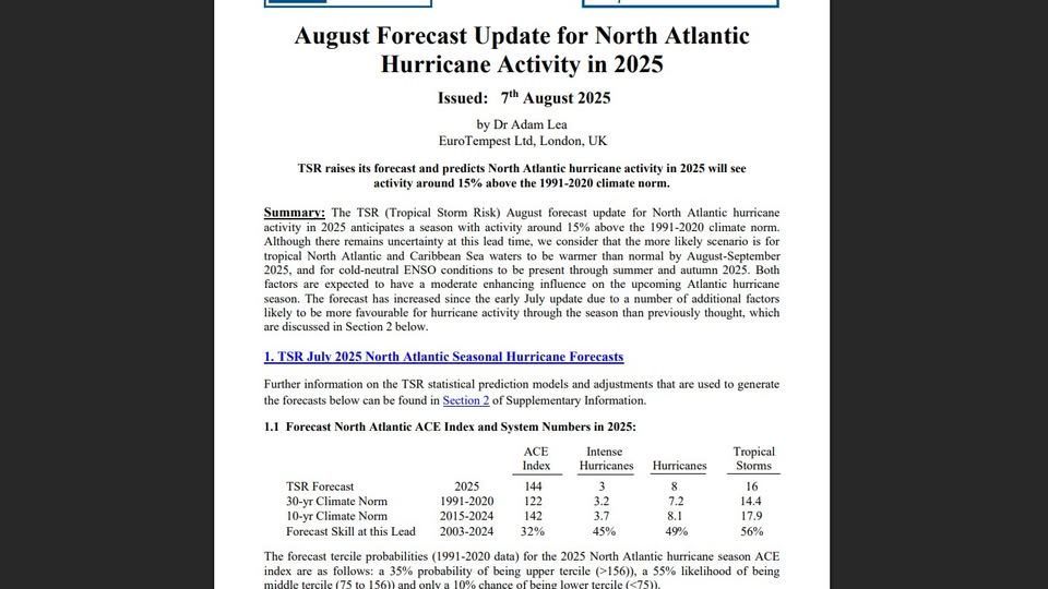
Since Atlantic ACE is considered to be a winter forecast factor: TSR just updated their forecast from last month…. -ACE increased markedly from 126 to 144. This compares to the CSU’s 145 and the Euro seasonal’s ~155. -The # of NS/H/MH increased slightly from 15/7/3 to 16/8/3. -However, US impacts remained the same at 4 NS/2 H. https://www.tropicalstormrisk.com/docs/TSRATLForecastAugust2025.pdf
-
SE Area of Interest--10% two day, 30% five day odds
WxWatcher007 replied to WxWatcher007's topic in Tropical Headquarters
It being unable to sustain meaningful convection last night definitely hurt chances imo but I still think it has a chance once it turns NE. -
TSR just updated their forecast from last month: -ACE increased markedly from 126 to 144. This compares to the CSU’s 145 and the Euro seasonal’s ~155. -The # of NS/H/MH increased slightly from 15/7/3 to 16/8/3. -However, US impacts remained the same at 4 NS/2 H. https://www.tropicalstormrisk.com/docs/TSRATLForecastAugust2025.pdf
-
Probably will be for life
-
2025-2026 ENSO
Stormchaserchuck1 replied to 40/70 Benchmark's topic in Weather Forecasting and Discussion
This Summer has been significantly cooler in the Southwest, US. Last year Phoenix was breaking records by >+2F, and the roll forward of those very warm analogs had a +PNA in Dec-Jan.. It was a good indicator. But we don't have that this year. -
2025-2026 ENSO
40/70 Benchmark replied to 40/70 Benchmark's topic in Weather Forecasting and Discussion
I just hope to god its wetter for the NE or I'll plunge into the Japanese piss-pool. -
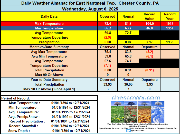
A great stretch of weather ahead with slowly warming temperatures. After a weekend with below normal temperatures with overnight lows in the 50’s and highs not too far from 80 degrees we should see temps getting well into the 80's by the start of the new work week. There could even be some 90's especially as usual across the valley locations by the middle of the week. No rain chances till at least Wednesday.