All Activity
- Past hour
-
She was very loved especially in Tennessee where she helped a ton after the wildfires tore through there.
- Today
-
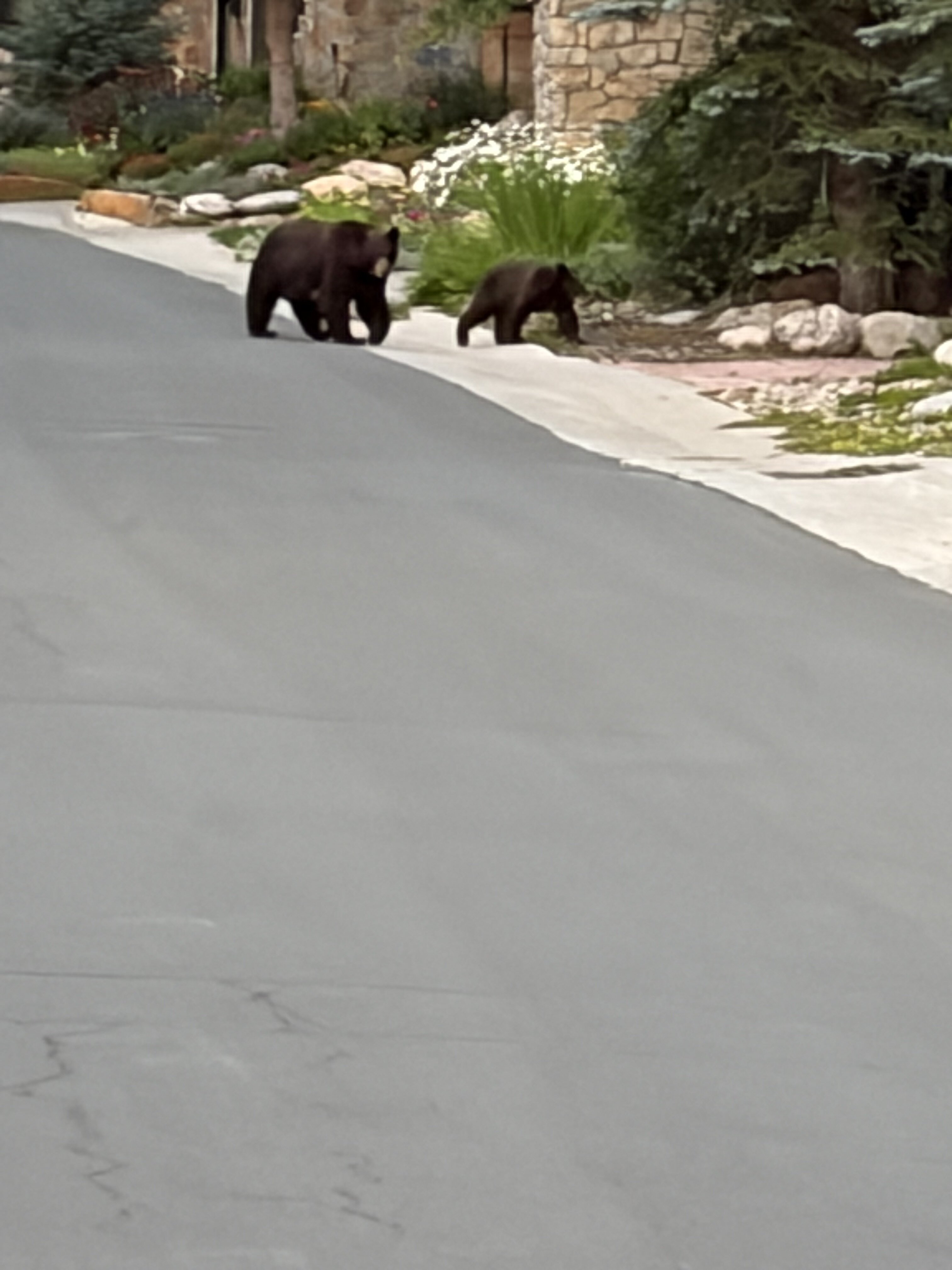
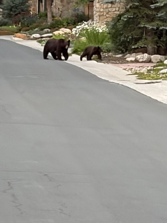
Early this evening here in the overall still very dry CO high country I saw this at a distance down the road I was taking a leisurely walk on, a first for me to see in the wild anywhere! The drought is so bad here that their natural food supply of berries, etc, is way below normal! This was surrealistic:
-
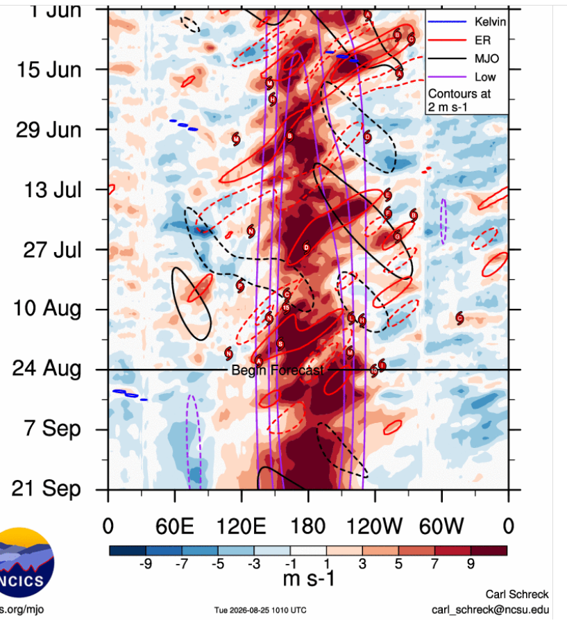
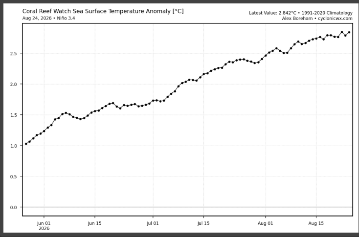
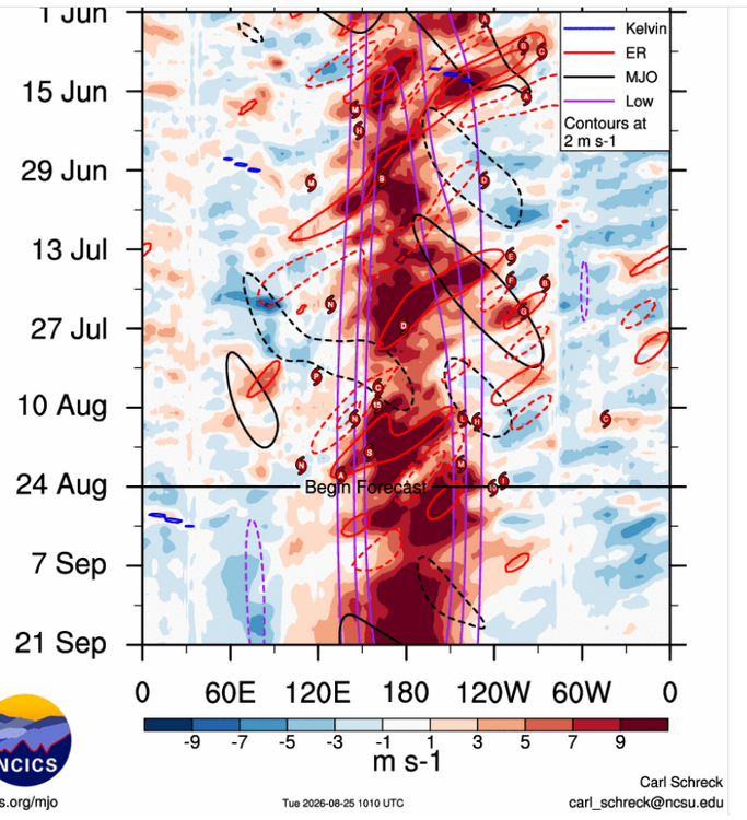
NINO looks still strong to me,you even see another strong WWB into Sept with hardly any EWB,start seeing EWB around South America should be one of the first signs the Walker Circulation is breaking down,until then
-
 https://northtrustpharm.com/# NorthTrust Pharm
 -
0Z UKMET delays transition to a TD for 4 days vs the 12Z run but still has it taking a similar path and gets to a TS quickly as it moves WNW a little NE of the Bahamas: NEW TROPICAL CYCLONE FORECAST TO DEVELOP AFTER 126 HOURS FORECAST POSITION AT T+126 : 20.3N 67.4W LEAD CENTRAL MAXIMUM WIND VERIFYING TIME TIME POSITION PRESSURE (MB) SPEED (KNOTS) -------------- ---- -------- ------------- ------------- 1200UTC 31.08.2026 132 21.0N 68.5W 1011 32 0000UTC 01.09.2026 144 22.4N 70.3W 1009 38 1200UTC 01.09.2026 156 23.0N 71.7W 1006 43 0000UTC 02.09.2026 168 24.1N 73.4W 1002 39
-

Augdewst 2026: Summer's Last Stand
Weather_or_Not replied to Prismshine Productions's topic in New England
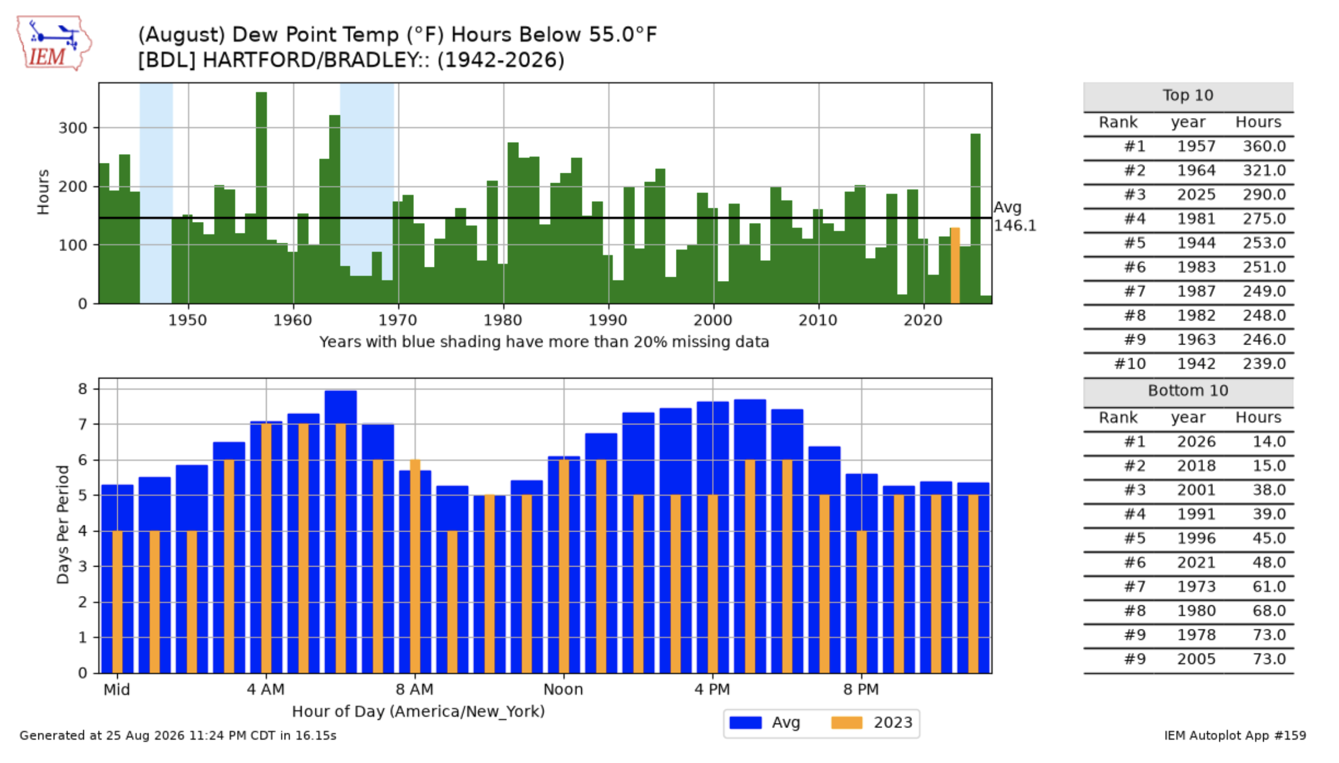
Note the lack of actual crisp air (SUB 55 DEWS) on this chart. 2025 had 290 hours under 55 DP (3rd best), 2026 has 14 hrs (all time worst). Here's hoping Saturday brings us our first crisp day (low 50s dew) of August - fingers crossed!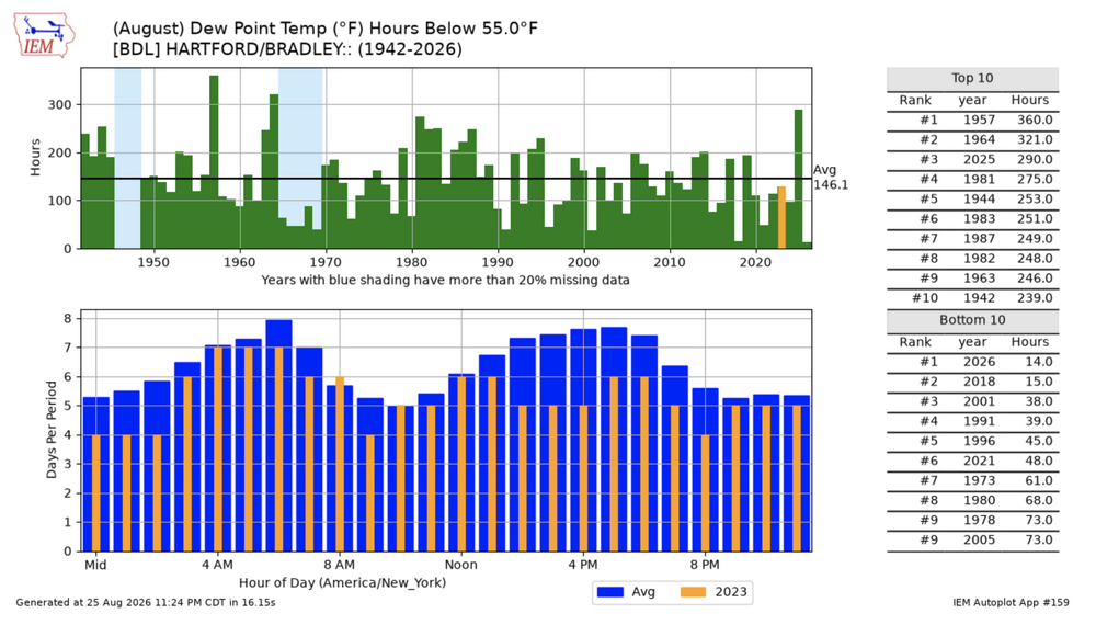
-
That not true to some extent,while the 82-83 strong NINO showed a -PDO into srping it went positive into summer.That 82-83 winter was quite uniques alone which had the help of a EQBO and not a WQBO this year
-
I don’t recall ever hearing/reading even one bad word about Dolly. Never! How many public figures can you say that about in our lifetimes?
-
I’ve rarely if ever heard/read one bad word about Dolly. Never! How many public figures can you say that about? Yes, one part of her anatomy was often made fun of, but that seemed to be mainly in good fun even if sometimes coming off as rude and she seemed to take it well with great responses.
-
Can you show me which stations in our sub-forum that is true for? This has not been an extremely hot summer, those surges of heat we had were short lived. This was a typical summer for the metro that featured warm and humid days and a stormy pattern starting after the 4th. It's interesting because if we had the inverse of this summer pattern happen in the winter (some extremely cold days mixed in with mostly average/warmer ones), you wouldn't have people going around saying that it's an icebox record cold winter.
-

2026-2027 Record-breaking El Nino
EasternLI replied to Stormchaserchuck1's topic in Weather Forecasting and Discussion
Yeah. You would expect to see some recurving typhoons instead of that. Key part of the puzzle IMO. Which we are still waiting for... -

2026-2027 Record-breaking El Nino
LakePaste25 replied to Stormchaserchuck1's topic in Weather Forecasting and Discussion
+PDO tends to be more indicative that the Pacific was in more of a nino state during the past 5-10 years and vice versa so that makes sense. Weak ENSO is going to have high variability. -
Looks like the Nino flatlined a little more than expected the last week or two. It's actually weakening considerably in 3-4. It may not quite peak as high as predicted. Regarding the PDO. Nino winters had positive PDO in something like 80 percent of moderate to strong ninos. 2023-24 was the only -pdo winter for one of them in the last 75 years.
-
 In some months the PDO correlates higher with US Temperature than ENSO. In a few months it actually scores higher than the PNA!
 -
2026-2027 Record-breaking El Nino
LakePaste25 replied to Stormchaserchuck1's topic in Weather Forecasting and Discussion
If this event doesn’t strongly couple then we need to start making PDO threads rather than ENSO threads. -

2026-2027 Record-breaking El Nino
jaxjagman replied to Stormchaserchuck1's topic in Weather Forecasting and Discussion
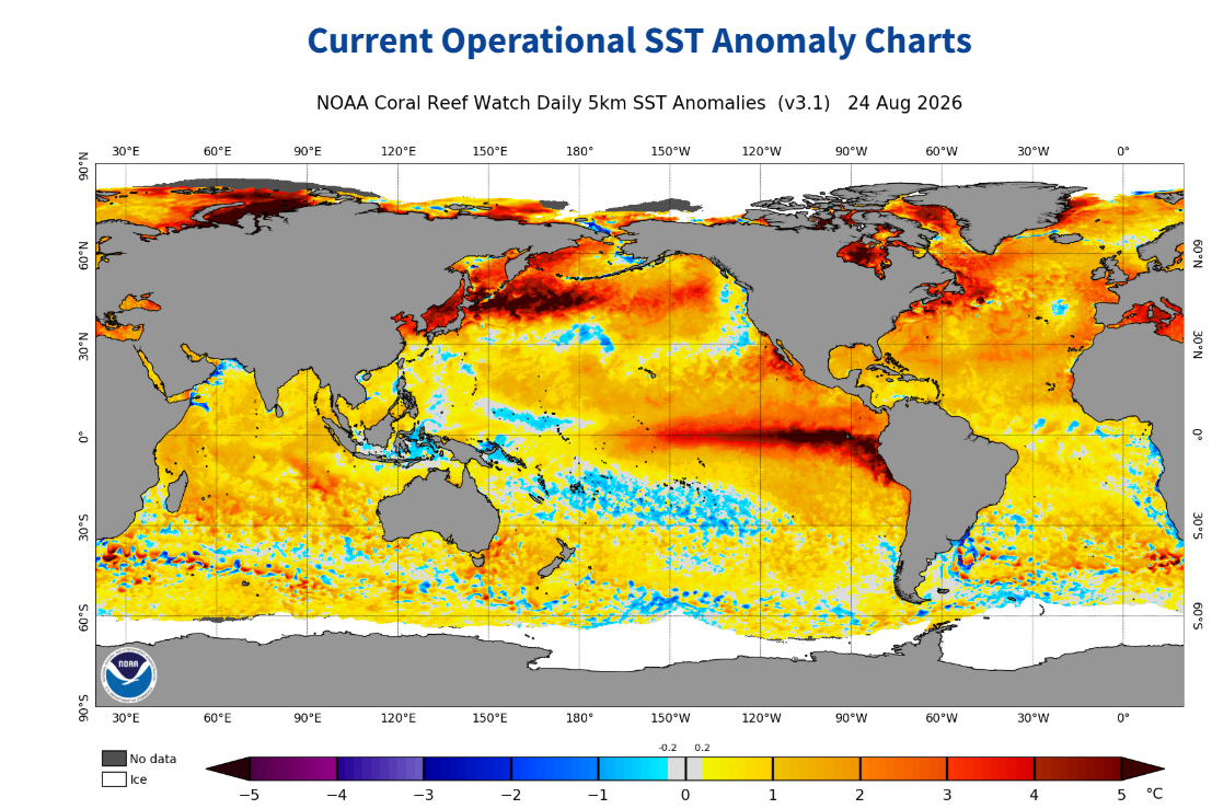
I agree with you,it dont seem like when the monthly updates you should see much change with a typhoon going into East China the next couple days.Look at how warm those SST's are east Japan into the Pac.Its rare in a strong NINO to even witness this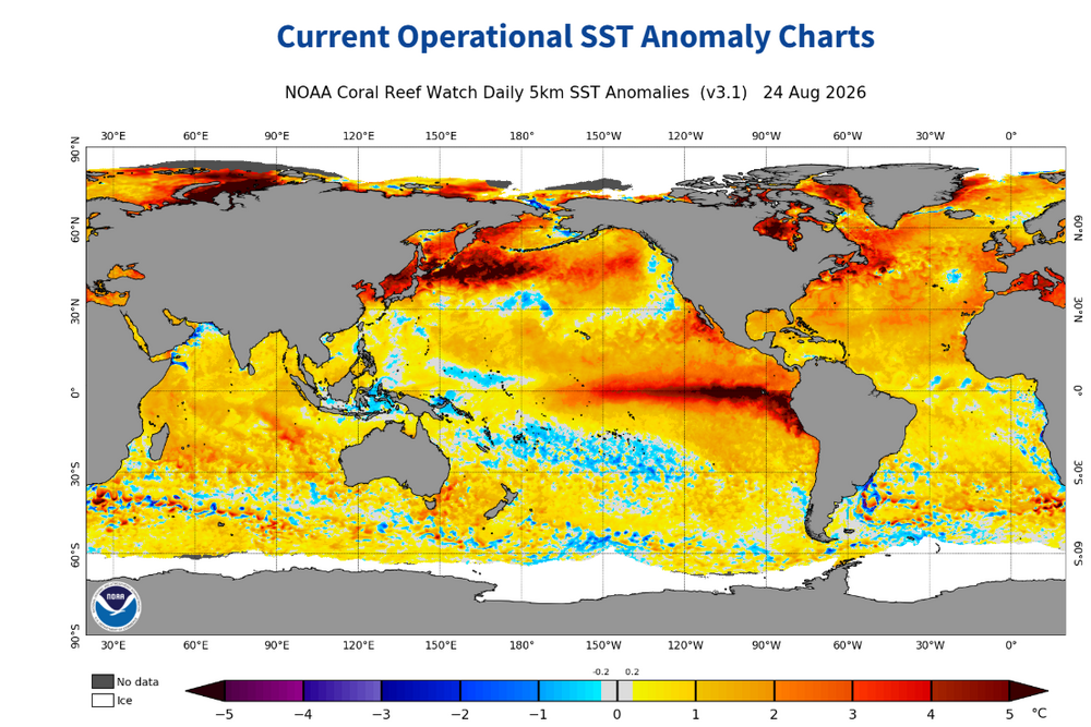
-
2026-2027 Record-breaking El Nino
EasternLI replied to Stormchaserchuck1's topic in Weather Forecasting and Discussion
Disagree that the odds are nearly zero. I do agree that the sheer magnitude of this el nino prevails. And I believe this autumn will do major work on that. However I also believe it is a true battle between the two. As the upper air pattern driving said PDO are fighting against it. PDO after all is a reflection of a predominant 500mb pattern. It takes effort to transform that as research shows. A major driver of this is known to be aleutian low variability. So it will be fascinating how that shakes out. The runaway strengthening on pause currently could be a little clue towards that. Or maybe not, but I would not be overly confident in either, and I am not. -
October 2024 PDO hit a 150-year low. Then in July 2025 it beat that, going lower. Now relative to ENSO it's probably just as impressive as Oct 2024 and July 2025. Don't think you can call a peak in the cold phase yet.
-

2026-2027 Record-breaking El Nino
40/70 Benchmark replied to Stormchaserchuck1's topic in Weather Forecasting and Discussion
This will couple more than 2024 at the height of the cold phase. -

Winter 2026-2027 Speculation
Prismshine Productions replied to 40/70 Benchmark's topic in New England
Man I am moving near a cliff don't do this to me Sent from my SM-S176V using Tapatalk -

2026-2027 Record-breaking El Nino
ensonerd1233e343 replied to Stormchaserchuck1's topic in Weather Forecasting and Discussion
thanks -
2026-2027 Record-breaking El Nino
40/70 Benchmark replied to Stormchaserchuck1's topic in Weather Forecasting and Discussion
https://www.data.jma.go.jp/tcc/tcc/products/clisys/figures/db_hist_3mon_tcc.html -
Something to consider as models show nearly a 6000dm ridge south of the Aleutian islands in 4-5 days, here are the last 3 El Nino Winters:
-
Yeah the GFS short to medium term backoff was expected, though the later window for recovery and potential intensification north of the islands is real. Future Dolly has the cards stacked against it in terms of making it to that pocket however. The shear is very real, as well as decreasing RH. Basin tenor has been very hostile this year, it just seems so much more likely that this fragile system will dissipate with a whimper. Some classic survivor bias within ensemble intensity forecasts down the line, and even that has been reduced as we've seen downtrending across the board today. Most AI ensemble members don't even show a TC anymore!
-
Everyone falls into the analog trap. 23-24 didn't couple and it peaked at +2.0c Here are the last 3 El Nino Winters: