All Activity
- Past hour
-

12/3 Snow/Sleet/Mix Bag of Everything Discussion/OBS
Mikeymac5306 replied to Mikeymac5306's topic in Philadelphia Region
WWA hoisted for MBY -

First Winter Storm to kickoff 2025-26 Winter season
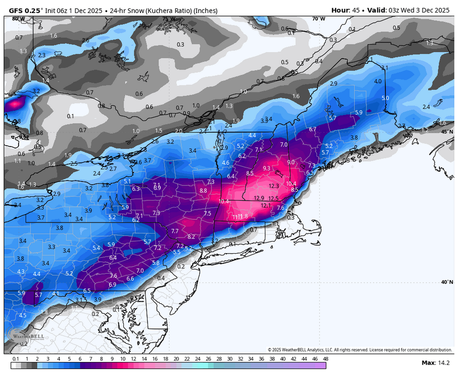
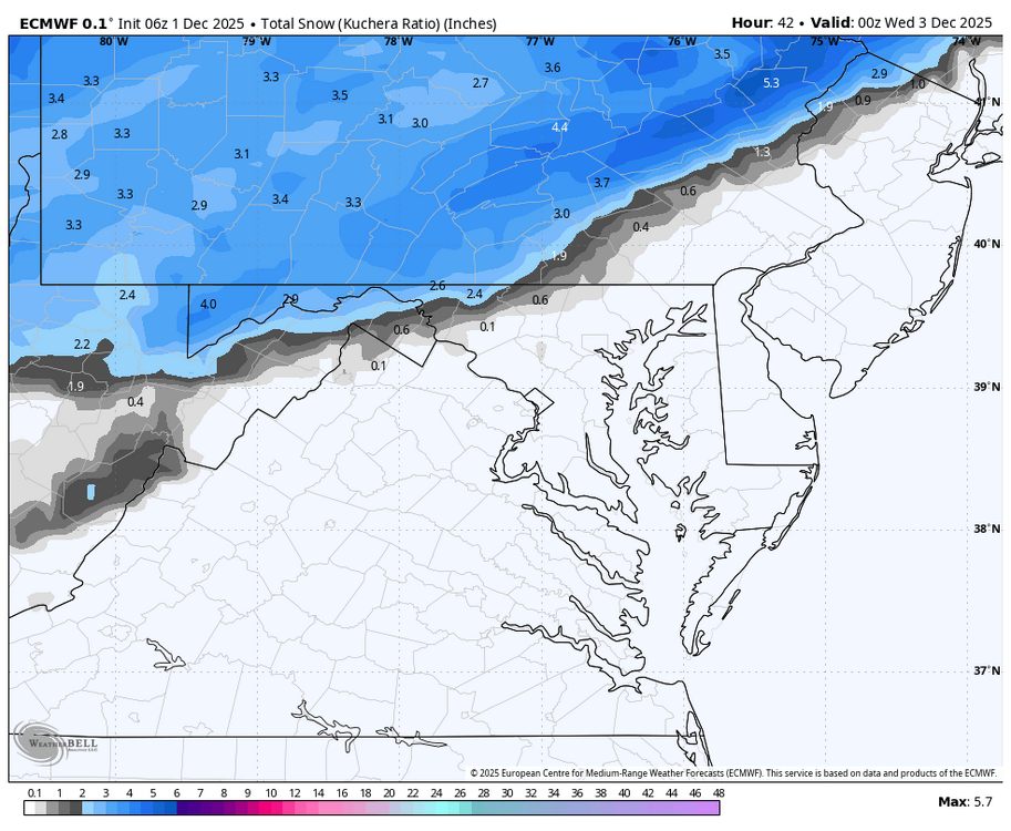
ORH_wxman replied to Baroclinic Zone's topic in New England
Yeah I think we’ve narrowed the goalposts down to just 25 miles or so but that still leaves a tough forecast because of how marginal the thermal profiles are across such a large area of more densely populated area. Metrowest down through Hartford region is gonna be a hard forecast. -
Reminds me of Jan 2024 when we got two northern stream waves that trended south with the PV push and hit us with a pair of 2-4"/3-5" snowfalls a week apart. And that was during an el nino winter, ironically. This is likely the best case scenario in a NS-dominant regime as depicted above.
-

First Winter Storm to kickoff 2025-26 Winter season
TauntonBlizzard2013 replied to Baroclinic Zone's topic in New England
Brutal sensible weather performance here. I’m sure it nailed H5 over Madagascar though. -

First Winter Storm to kickoff 2025-26 Winter season
WinterWolf replied to Baroclinic Zone's topic in New England
So are we at a consensus do you think with the 6z? The GFS shifting south some has a decent event here….and if the Euro has the same that adds some credence. -
E PA/NJ/DE Winter 2025-26 Obs/Discussion
Mikeymac5306 replied to LVblizzard's topic in Philadelphia Region
Been out of the office all week and I always lose track of days when I'm not there lol! -
Lol. Hrrr and gfs come in with the good stuff and euro says “just kidding.” .
-
12/3 Snow/Sleet/Mix Bag of Everything Discussion/OBS
Mikeymac5306 replied to Mikeymac5306's topic in Philadelphia Region
Of course, models will flip a 180 24 hrs. out lol! -
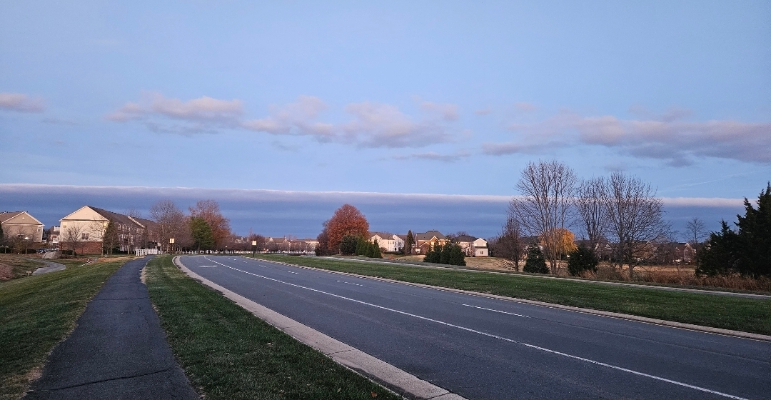
Out for my morning walk pretty neat cloud deck to the west

-

Central PA Fall Discussions and Obs
Blizzard of 93 replied to ChescoWx's topic in Upstate New York/Pennsylvania
I like this CTP call for most of the region, but I think a few lucky spots could get closer to 5 depending on where the heaviest bands set up. -
Central PA Fall Discussions and Obs
Blizzard of 93 replied to ChescoWx's topic in Upstate New York/Pennsylvania
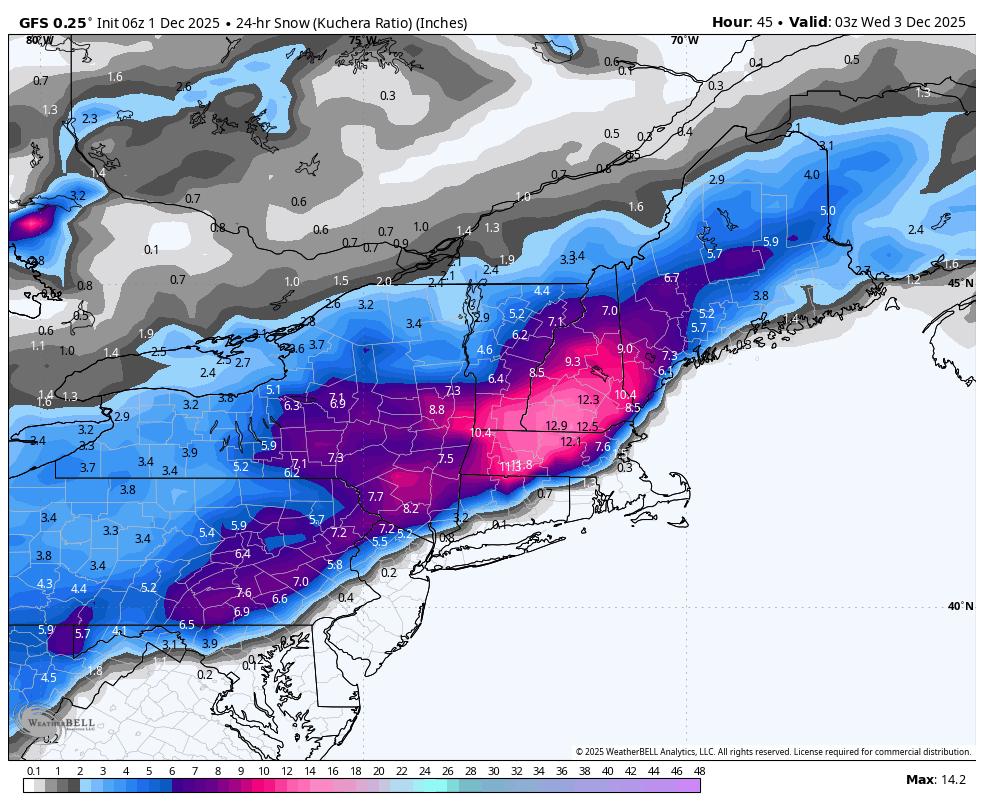
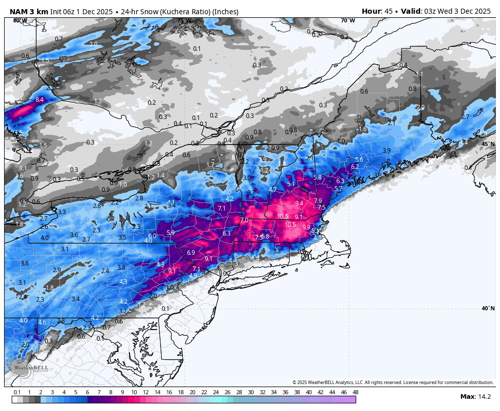
NAMs finally at 6z jumped on board for most of us & the GFS held serve too.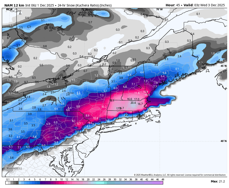

-
Central PA Fall Discussions and Obs
Blizzard of 93 replied to ChescoWx's topic in Upstate New York/Pennsylvania
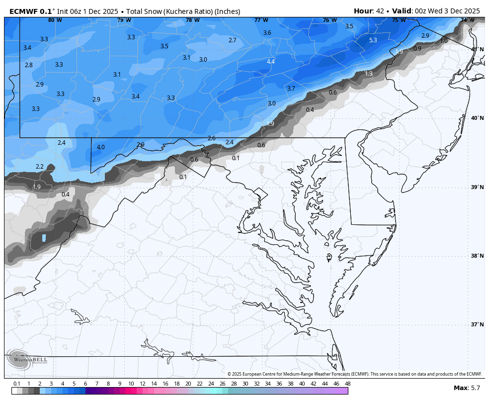
Winter Weather Advisory URGENT - WINTER WEATHER MESSAGE National Weather Service State College PA 157 AM EST Mon Dec 1 2025 ...FIRST WIDESPREAD SNOW OF THE SEASON... .A quick-hitting system will bring accumulating snow to all of Central PA late Monday night into early Tuesday afternoon. Hazardous travel is expected for the morning commute on Tuesday, with a plowable snow expected areawide. Snow may mix with sleet or freezing rain near the Mason-Dixon line, where a glaze of ice is possible. Snowfall totals over 6 inches are possible at higher elevations east of US-15 and north of the I-81/I-78 corridor. PAZ012-018-019-025>028-045-049-050-056-057-059-063-012100- /O.NEW.KCTP.WW.Y.0023.251202T0800Z-251202T1800Z/ Northern Clinton-Northern Centre-Southern Centre-Blair-Huntingdon- Mifflin-Juniata-Southern Clinton-Union-Snyder-Perry-Dauphin- Lebanon-Cumberland- Including the cities of Renovo, Altoona, Philipsburg, Lebanon, Lewistown, Newport, Lock Haven, Lewisburg, State College, Harrisburg, Mount Union, Mifflintown, Carlisle, Selinsgrove, Hershey, and Huntingdon 157 AM EST Mon Dec 1 2025 ...WINTER WEATHER ADVISORY IN EFFECT FROM 3 AM TO 1 PM EST TUESDAY... * WHAT...Snow expected. Total snow accumulations between 2 and 4 inches. * WHERE...A portion of central Pennsylvania. * WHEN...From 3 AM to 1 PM EST Tuesday. * IMPACTS...Roads, and especially bridges and overpasses, will likely become slick and hazardous. Plan on slippery road conditions. The hazardous conditions will impact the Tuesday morning commute. * ADDITIONAL DETAILS...Snowfall rates up to 1 inch per hour are possible. PRECAUTIONARY/PREPAREDNESS ACTIONS... Slow down and use caution while traveling. The latest road conditions for the state you are calling from can be obtained by calling 5 1 1. -

First Winter Storm to kickoff 2025-26 Winter season
TheMainer replied to Baroclinic Zone's topic in New England
Based on everything I've seen, I'm feeling 4 inches is what we're going to end up with here, "far" NNE is not the place to be for this. A little overdone by CAR I think, but you never know.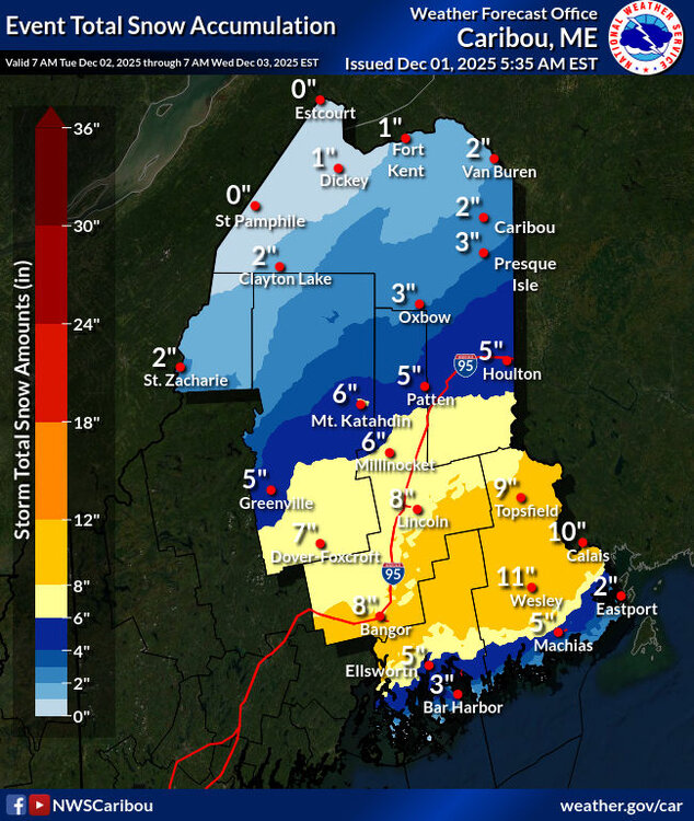
-
First Winter Storm to kickoff 2025-26 Winter season
ORH_wxman replied to Baroclinic Zone's topic in New England
06z euro kind of looks like 06z GFS. They are pretty close now. -
I think that is about right for TRI. It was basically a seasonal month for us. I did check several stations which weren't near big airports, and some of those stations had higher departures. I think higher elevations and folks w/ slightly northern latitudes were slightly cooler. During 3-4 consecutive mornings recently we had very heavy fog which elevated temps above morning norms. The final average for TRI is 0.8F. It came out this morning. We were about 1" BN for precip. Highs were slightly AN and lows were slightly BN(which probably runs against my fog theory!). That does kind of fit a slightly drier month than normal - like a desert in some ways.
-
6th event kind of fell off the ledge last night. I dont think the pattern looks bad from 6-12th or so. However, to me it seems like a very Northern Stream dominant pattern, so keep an eye on one of those clipper type waves with enough space to redevelop or at least be strong enough itself to give us some flakes during that time period. Would need a little support from the PNA and too to help amplify any of those waves that flow across the NS. .
-

First Winter Storm to kickoff 2025-26 Winter season
Ginx snewx replied to Baroclinic Zone's topic in New England
Good -
First Winter Storm to kickoff 2025-26 Winter season
TauntonBlizzard2013 replied to Baroclinic Zone's topic in New England
Euro tickling warmer is not surprising at all. Classic -

Central PA Fall Discussions and Obs
mahantango#1 replied to ChescoWx's topic in Upstate New York/Pennsylvania
Hopefully you'll cash in on that low temp...and you'll beat my low temp. -
WB 6Z EURO is a rug pull...
-
First Winter Storm to kickoff 2025-26 Winter season
Ginx snewx replied to Baroclinic Zone's topic in New England
You are solid there. -
First Winter Storm to kickoff 2025-26 Winter season
Ginx snewx replied to Baroclinic Zone's topic in New England
With a bunch of isothermic soundings I could see if rates materialize those on the edge getting smoked. -
Classic La Nina
-
What else is new. Dry has been the name of the game.
-

First Winter Storm to kickoff 2025-26 Winter season
UnitedWx replied to Baroclinic Zone's topic in New England
Bob Cox on WTIC super conservative as of this morning (as always), going for 3 to 6 in the hills with about an inch everywhere else. I just don't see that myself with the overnight slight trends. I could see 3 to 6 near Hartford to BDL and 4 to 8 in the hills