All Activity
- Past hour
-
Nothing from the Winthrop CWOP. https://www.weather.gov/wrh/timeseries?site=D3706&hours=24
-
Beer?
-
It's a little too early in the day for rain. It's a nice respite, but once this passes and the sun comes back out it's gonna be a hellish sauna out here.
-
I don’t have any physical records but I don’t recall 3 straight days of 90+ here since 2005. Did ORH do it then?
-
 So far-high of 96 at FRG, 97 for ISP.
 -
I would also expect to see a baro change and dewpoint change with such temp fluctuations and I don't see any.
-

E PA/NJ/DE Summer 2025 Obs/Discussion
JTA66 replied to Hurricane Agnes's topic in Philadelphia Region
I think Storm Ranger10 is in for an oil change. 96F/DP 75F...getting an occasional cloud passing by. -
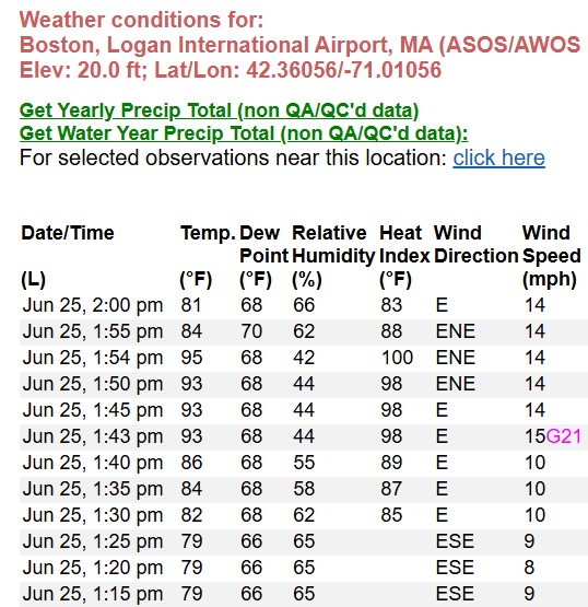
Jun 25, 1:55 pm 84 70 62 88 ENE 14 10.00 SCT060 29.96 29.98 Jun 25, 1:54 pm 95 68 42 100 ENE 14 10.00 FEW037 BKN065 1015.10 29.96 29.98 95 78 Jun 25, 1:50 pm 93 68 44 98 ENE 14 10.00 SCT050 BKN070 29.96 29.98 Jun 25, 1:45 pm 93 68 44 98 E 14 10.00 SCT050 BKN070 29.96 29.98 Jun 25, 1:43 pm 93 68 44 98 E 15G21 10.00 SCT050 BKN070 29.96 29.98 Jun 25, 1:40 pm 86 68 55 89 E 10 10.00 BKN050 BKN070 29.96 29.98 Jun 25, 1:35 pm 84 68 58 87 E 10 10.00 BKN050 BKN070 29.95 29.97 Jun 25, 1:30 pm 82 68 62 85 E 10 10.00 BKN050 BKN070 29.96 29.98 Jun 25, 1:25 pm 79 66 65 ESE 9 10.00 BKN050 BKN070 29.96 29.98
-
Yeah something is wrong. To pull down a 5min mean from 95F to 84F in 1 minute requires a big number coming off and a big one going on.
-
yeah ha just typed a similar explanation
-
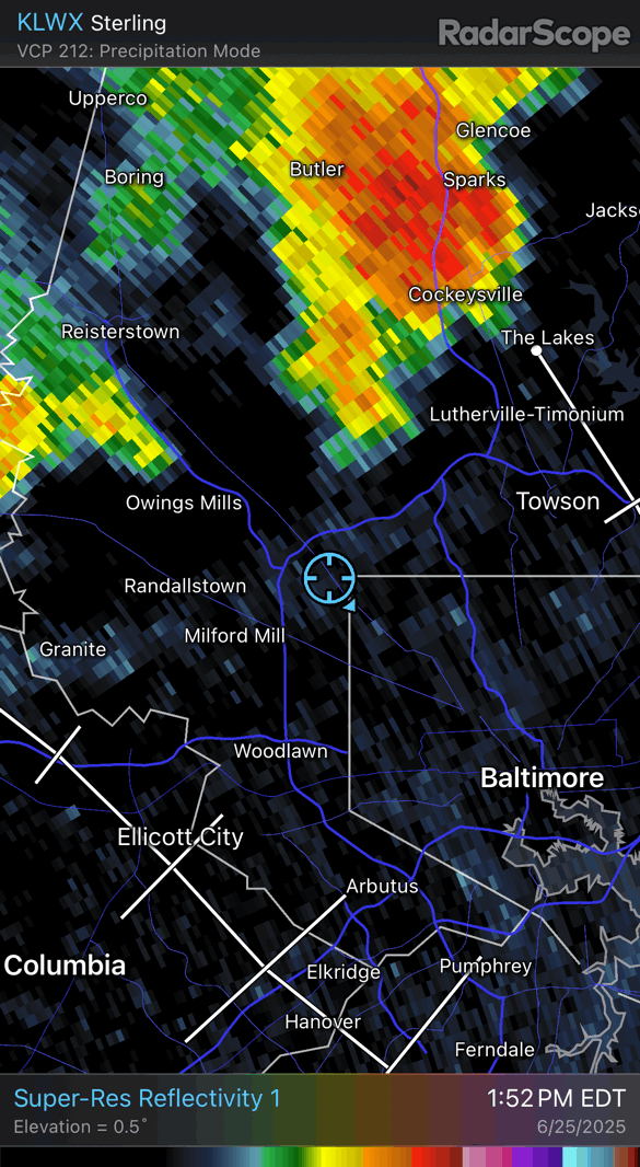
The severe storm missed me at the house but knocked power out at the office which kicked me off the network and my mapping haha
-
I bet that's low level folding There's NW wind moving into Boston and it's "tipping" the air mass over the really shallow E component and it may be mixing irregularly back down
-
 98 is the high here so far
 -
Must be some swirlies in there. Back to 81F
-
Damn! I got Stephens City’d!!!

-
I don't know, but something is off. I can't explain it as a rogue heat plume off the runway.
-
1 minute. 1:54pm... 95F 1:55pm... 84F
-
100/67 at KGED (Georgetown DE) at 1:35 PM 98/73 at 1:55 PM in KDOV. Almost there
-
 Looks like the high was 102 again at JFK.
 -
Back down to 81F. That's a swing. What happened from 1:40pm to 1:43pm? And then 1:54pm to 1:55pm.
-
 94/74 for me in Lindenhurst, heat index at 105 again.
 -
Made it to 92 so far today. With clouds & scattered thundershowers, that’s probably as high as it will get today.
-
Everyone around them is low 80s
-
International Falls getting their earliest 70° minimum by 35 days back in May was probably the most impressive temperature record for the CONUS this year so far at a +33° minimum. CLIMATE REPORT NATIONAL WEATHER SERVICE DULUTH MN 426 PM CDT MON MAY 12 2025 ................................... ...THE INTERNATIONAL FALLS CLIMATE SUMMARY FOR MAY 12 2025... VALID TODAY AS OF 0400 PM LOCAL TIME. CLIMATE NORMAL PERIOD: 1991 TO 2020 CLIMATE RECORD PERIOD: 1895 TO 2025 WEATHER ITEM OBSERVED TIME RECORD YEAR NORMAL DEPARTURE LAST VALUE (LST) VALUE VALUE FROM YEAR NORMAL ................................................................... TEMPERATURE (F) TODAY MAXIMUM 90R 2:59 PM 86 1991 63 27 67 MINIMUM 70 5:43 AM 18 2020 37 33 40 AVERAGE 80 50 30 54