
All Activity
- Past hour
-

Augdewst 2026: Summer's Last Stand
WxWatcher007 replied to Prismshine Productions's topic in New England
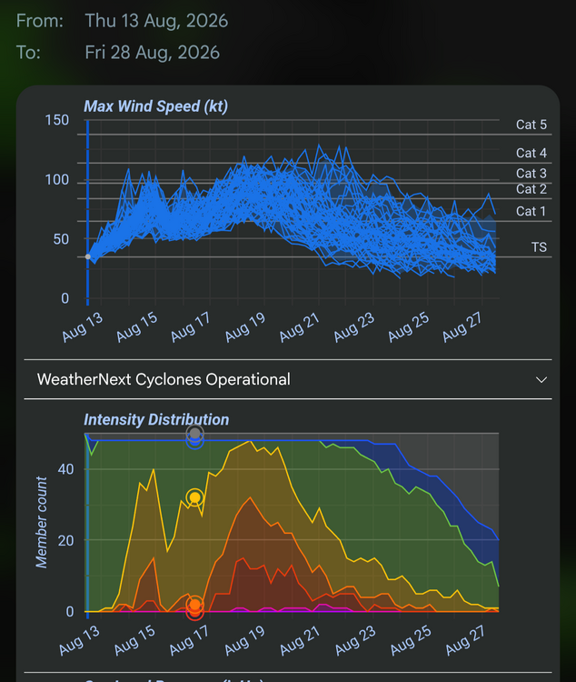
95/74 is not our climo on August 13th Would’ve been a good chase trip but the logistics are a mess and I’m thinking the center passes south of the big island as a strong TS, not hurricane. I try to stay away from Island Roulette. -
Meteorological summer is June, July and August while the hottest part of summer average wise is approximately June 10th to September 10th
-

Augdewst 2026: Summer's Last Stand
Lava Rock replied to Prismshine Productions's topic in New England
we got hail -
Augdewst 2026: Summer's Last Stand
78Blizzard replied to Prismshine Productions's topic in New England
Here we go again with the model wars. The 12z GFS has the 9 day here at 100ºF, while both the Euro and CMC have us at 72ºF. Both the Euro and CMC have deep troughs over the east at 500 mb, while the GFS has nothing. -

2026-2027 Record-breaking El Nino
michsnowfreak replied to Stormchaserchuck1's topic in Weather Forecasting and Discussion
Same for Detroit. 3rd coldest for that period, behind those same 2 years. Thats also the coldest time of the year on record climatologically, so extra impressive. 8.7F – 1895 10.1F – 1936 12.3F – 2026 12.6F – 1899 12.9F – 1918 -
Augdewst 2026: Summer's Last Stand
Lava Rock replied to Prismshine Productions's topic in New England
Looks like my work cube over by riverside golf course is inline. Will find out soon. Sent from my SM-S921U using Tapatalk -
2026-2027 Record-breaking El Nino
michsnowfreak replied to Stormchaserchuck1's topic in Weather Forecasting and Discussion
I dont think it was overhyped AT ALL. In fact, everytime someone on here spoke about the abnormal cold they were inundated with how warm it was out west. There was some very impressive cold stretches. It was the 3rd coldest Jan 15-Feb 9 on record at Detroit. The first half of December was 5th coldest on record. In the end, the average winter temperature was solidly below avg based on any 30-year normal or the entire climate POR. It was the coldest since 2014-15. In a winter that was expected by many to be mild, it was solidly colder than avg in the Lakes/East. No one said it was record cold, but its also a copout to use a phrase like "its winter its supposed to be cold". Thats why averages exist. For Detroit, it was 44th coldest of 153. For Erie, PA it was 35th coldest of 153. At NYC it was 43rd coldest of 158. -

Augdewst 2026: Summer's Last Stand
weatherwiz replied to Prismshine Productions's topic in New England
Great write up by Ryan https://ryanhanrahan.substack.com/p/incredible-103-mph-wind-gust -

Augdewst 2026: Summer's Last Stand
CoastalWx replied to Prismshine Productions's topic in New England
One massive MEH for sure. -
Augdewst 2026: Summer's Last Stand
CoastalWx replied to Prismshine Productions's topic in New England
Now that the ponds and reservoirs are the lowest they've been all summer, they bring it only to abnormally dry. Meanwhile it was severe drought when everything was full. Shoot those products to the sun. -
 Maple Trust Rx: canadian pharmacy king reviews - Maple Trust Rx
 -

2026-2027 Record-breaking El Nino
raindancewx replied to Stormchaserchuck1's topic in Weather Forecasting and Discussion
PDO has definitely weakened toward neutral in recent days. Net trend will be more positive. It's just whether that continues into actual positive territory and sustains. The North Atlantic on the other hand has also warmed up quite a bit. -
-

Augdewst 2026: Summer's Last Stand
tunafish replied to Prismshine Productions's topic in New England
Those that miss to your south inevitably find a way to whiff me too. -
The WDI clears this. Going on 11 years without even a pure 6-8+ inch snowfall. I don’t think it gets talked about enough how dreadful of a stretch that is. I feel like it gets talked about that we haven’t had an HECS or MECS in a decade, but honestly a good portion of the region hasn’t even had a SECS in that time
-
I just downloaded it. You're right! It does seem to compute a bit heavy. I looked at the past week data and their readings for my yard are about .05" heavy each day. That's not a big deal unless your events are .10", or less, like all mine. Lol.
-

Augdewst 2026: Summer's Last Stand
vortex95 replied to Prismshine Productions's topic in New England
Two days in a row supercells in cntrl VT. The action ydy during the day, overnight, and now tdy over-performing, and @CoastalWx still be like MEH! -
Augdewst 2026: Summer's Last Stand
weatherwiz replied to Prismshine Productions's topic in New England
72 dbz to 14k from Albany radar. Must be dropping at least 1.5" hail. -
I’ll be on Big Island till Monday… yikes
-

Augdewst 2026: Summer's Last Stand
ineedsnow replied to Prismshine Productions's topic in New England
Warned now -
farmacia mexicana online or mexico prescriptions can i buy meds from mexico online http://www.110school.ru/bitrix/rk.php?goto=http://mexisaferx.shop/ mexico farmaciaor http://www.freeworld.imotor.com/space.php?uid=216401 farmacia mexicana en linea [url=https://images.google.tk/url?q=https://mexisaferx.shop]pharmacy in mexico city[/url] mexico online pharmacyand [url=https://www.liveviolet.net/user/fhnyxumeex/videos]mexican pharmacy near me[/url] mexican mail order pharmacy
-
Augdewst 2026: Summer's Last Stand
Lava Rock replied to Prismshine Productions's topic in New England
all the good ones go south of us and over the lake -
Augdewst 2026: Summer's Last Stand
ineedsnow replied to Prismshine Productions's topic in New England
that storm west of Rutland VT looks like a beast -
Augdewst 2026: Summer's Last Stand
tunafish replied to Prismshine Productions's topic in New England
Let's get a waterspout on Sebago w/o GYX warning..thumb.png.4b14795d5da22e14ad5d4f02b5dc3875.png)
-
Augdewst 2026: Summer's Last Stand
ineedsnow replied to Prismshine Productions's topic in New England
beautiful rest of the week coming up!! This Afternoon Mostly sunny, with a high near 78. Northwest wind around 8 mph. Tonight Patchy fog after 2am. Otherwise, mostly clear, with a low around 54. West wind 3 to 5 mph. Friday Patchy fog before 7am. Otherwise, sunny, with a high near 76. Northwest wind 5 to 10 mph. Friday Night Mostly clear, with a low around 51. Calm wind. Saturday Sunny, with a high near 77. Calm wind becoming north around 5 mph in the afternoon. Saturday Night Mostly clear, with a low around 52. Calm wind. Sunday A chance of showers after 4pm. Mostly sunny, with a high near 76. Calm wind becoming southwest 5 to 7 mph in the afternoon. Chance of precipitation is 30%. Sunday Night Showers likely, mainly after 10pm. Mostly cloudy, with a low around 59. South wind around 7 mph. Chance of precipitation is 70%. Monday A chance of showers before 11am. Partly sunny, with a high near 77. Northwest wind 6 to 8 mph. Chance of precipitation is 40%. Monday Night Mostly clear, with a low around 55. Light northwest wind. Tuesday Sunny, with a high near 79. Calm wind becoming northwest around 5 mph in the afternoon. Tuesday Night Mostly clear, with a low around 56. Calm wind. Wednesday Sunny, with a high near 79. Calm wind becoming southwest 5 to 7 mph in the afternoon







.png.4b11228acd903a96230130d889c1975f.png)