All Activity
- Past hour
-
I like that. Cockiest ever!
-

Hurricane Erin: 140 MPH - 937 mb - NW @ 10
LongBeachSurfFreak replied to BarryStantonGBP's topic in Tropical Headquarters
We were starting to get some minor over wash at jones beach Ny. Expecting a boardwalk basher on Thursday. The pressure gradient and resulting strong NE winds will pile water up on the south shore of LI and lead to major inundation. Huge swells on top of above normal tides. This may be the most impactful coastal event in years. -
Uh yeah, most years especially recently, it does break in Feb. Days start getting noticeably longer, cold air masses are less potent. Doesn’t mean it won’t snow again Feb-April or we won’t have a really cold departure day just like I said we’ll still have warm days and even hot ones 90+, but the peak of it is behind us, like it or not
-
Somewhere in NYC, a patrol car just drove through a Macy’s and didn’t even notice.
-

Hurricane Erin: 140 MPH - 937 mb - NW @ 10
Floydbuster replied to BarryStantonGBP's topic in Tropical Headquarters
-
-
wish it ripped into W LI instead of limping, but take!
-
-
Outside with shorts and short sleeved shirt…not too bad actually. The coolness isn’t bothering like I thought it would. But I do miss 95/73
-
what the heck is going on?
-
Yeah I Know. That part is better. But risk is trough too far east. Eventually it will work out right? lol.
-
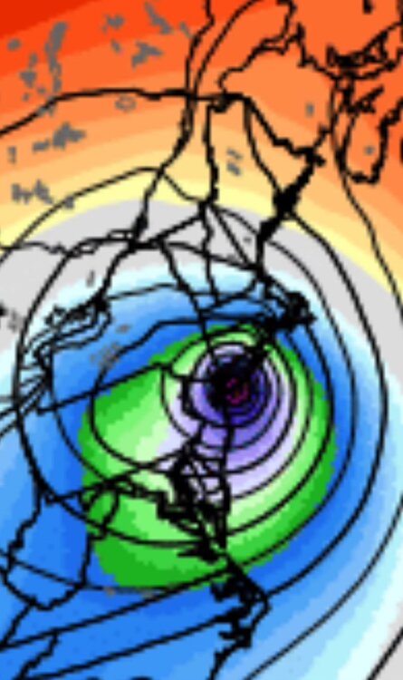
Man what a massive shift west today. Models really blew this one as did NHC . CC to ACK now into TS conditions
-
Happy hour on 18z GFS lol
-
I’m not so sure the Euro has that right but we’ll see. It’s not the prettiest trough/ridge combo but it’s better than what we have today lol. I can definitely see that wave struggling to consolidate until it gets past 60W.
-
How many you had ? Still early too
-
Picked up 0.06 from a decaying cell. This mornings progressive outflow boundary screwed us here for this setup. Will finish August with <1.25".
-
I’d lean Stein here.
-
Will be another fish storm lol.
-

Hurricane Erin: 140 MPH - 937 mb - NW @ 10
wthrmn654 replied to BarryStantonGBP's topic in Tropical Headquarters
Gfs another noticeable shift west and north.... lol this reminds me of winter storms the past few years non stop shifts... -
That's a monster hit sucks it's 10 days out
-
Ya can we just lock that in now lol
-
Doesn’t mean much of anything for us: meh. But looks like you initialized the next storm lol.
-
Drunk
-
Cocgust!
-
 74 for high Coldest day since 69 on 6/27 8 day heatwave comes to a crashing end


