All Activity
- Past hour
-

“Cory’s in NYC! Let’s HECS!” Feb. 22-24 Disco
40/70 Benchmark replied to TheSnowman's topic in New England
We need the follow up crap over MN to weaken....DT mentioned that and it's a solid point. -

Feb 22nd/23rd "There's no way..." Storm Thread
psuhoffman replied to Maestrobjwa's topic in Mid Atlantic
My fear is the inverted trough keeps trending east and we end up west of everything. That’s my “how we get screwed” vision. -
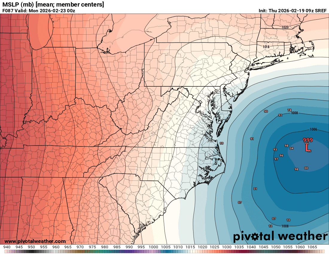
A lot of left learners on long range SREF

-
Sometimes there’s model wide failures in depicting features. There’s still time for that given the mess out west. But yeah, every 6hrs of near status quo won’t get us there.
-
“Cory’s in NYC! Let’s HECS!” Feb. 22-24 Disco
40/70 Benchmark replied to TheSnowman's topic in New England
I think that late January threat after the blizzard is a pretty good analog. -
First and probably last call unless something major changes. Another garbage nuisance event round here
-

Feb 22nd/23rd "There's no way..." Storm Thread
wasnow215 replied to Maestrobjwa's topic in Mid Atlantic
That seems like a very reasonable answer and thank you! So would you say it would be smart more to lean more on those "big 3" 5 to 7 days out of any event or other reasons people would look at medium range forecasts like travel, vacations, etc? Also do you think the GEM n Ukie should be given more credence than the GFS in the same time frame? -

Central PA Winter 25/26 Discussion and Obs
Blizzard of 93 replied to MAG5035's topic in Upstate New York/Pennsylvania
A compromise between the Euro & GFS would deliver a significant event to many of us. -

Feb 22nd/23rd "There's no way..." Storm Thread
LordBaltimore replied to Maestrobjwa's topic in Mid Atlantic
They're focusing on getting JEDI to one day work instead of tuning the old DA system. It will get better once people actually work on it -
Weather balloon data starts coming in with the 12z models. I think by then we really start getting a grip on who's getting what. IMO, the ridge is going to be a little too far east for the storm to gain enough latitude before kicking ots. Right now it's showing the ridge vertex over MT and WY. If that ridge retreats west to the ID/MT border, we're in business. For now I like Jersey Shore WWA scraper or a miss over a warning-critera snowfall.
-

E PA/NJ/DE Winter 2025-26 Obs/Discussion
anthonyweather replied to LVblizzard's topic in Philadelphia Region
Just about every on air met is doing it now, it’s maddening . -
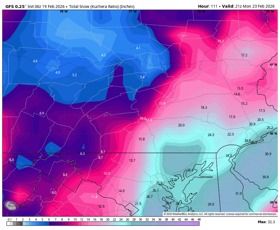
Most models like 0.50” or so for QPF for QPF here, some a tad more. Think we can do 4-7”.
-
“Cory’s in NYC! Let’s HECS!” Feb. 22-24 Disco
40/70 Benchmark replied to TheSnowman's topic in New England
Should we do a wellness check? -
Central PA Winter 25/26 Discussion and Obs
Blizzard of 93 replied to MAG5035's topic in Upstate New York/Pennsylvania
The 6z Euro gets a Warning level event to a good chunk of the LSV thanks to the Norlun trough setting up over our region.
-
@OrdIowPitMsp hope you visited Ice caves in the Apostles already, because the ice is now gone. Wind blew it away.
-
Why does it have to be headed anywhere?
-
“Cory’s in NYC! Let’s HECS!” Feb. 22-24 Disco
40/70 Benchmark replied to TheSnowman's topic in New England
Yea, it's going to be relatively close in a geographical sense....got it, but it seems pretty definitive that we aren't getting a blizzard. Been my take for days and I'm not seeing anything to give me pause. -
Thanks Will
-

“Cory’s in NYC! Let’s HECS!” Feb. 22-24 Disco
Kitz Craver replied to TheSnowman's topic in New England
Hallucinations a plenty -
I have a basic understanding of that. I just see that it’s bumped up a little bit but we’ve been consistent with .5 to .7 for three days so seeing the nam makes me be very confident in 4 to 8. And this kind of scenario is a 4 to 8 or 6 to 10 kind of scenario I think.
-
Central PA Winter 25/26 Discussion and Obs
Blizzard of 93 replied to MAG5035's topic in Upstate New York/Pennsylvania
The 6z GFS was likely the best case scenario & low likelihood of verifying, but my goodness is it beautiful for Sunday. Just 1 time could it be right?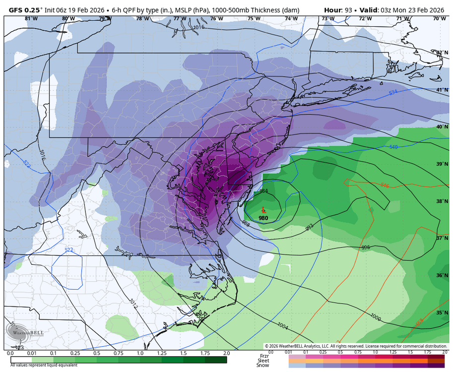
-
“Cory’s in NYC! Let’s HECS!” Feb. 22-24 Disco
40/70 Benchmark replied to TheSnowman's topic in New England
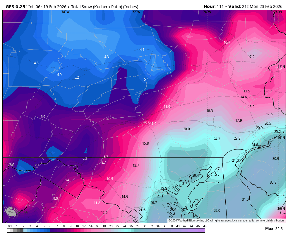
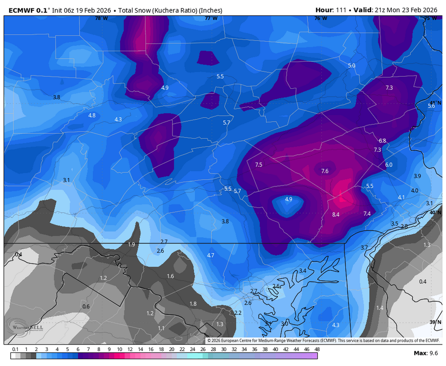
I really fail to see how anyone can take these two images in and be at a loss for where this is headed. -

Feb 22nd/23rd "There's no way..." Storm Thread
MillvilleWx replied to Maestrobjwa's topic in Mid Atlantic
I expect things begin consolidating within the next couple runs, then we parse details on ratios and location of the IVT. That is truly a difficult task in these setups too, so that could be a truly short term trend monitoring which I hate lol -
“Cory’s in NYC! Let’s HECS!” Feb. 22-24 Disco
Kitz Craver replied to TheSnowman's topic in New England
It’s like dryslot opined yesterday. When something major is imminent, you are inevitably going to see some huge hits. It’s just not there currently -
Or they basically said they don’t know lol to much uncertainty They don’t mention the op euro guess it’s not part of their thinking


.thumb.jpeg.f5c6ba9d911ec96b3b124f8606aee58e.jpeg)