All Activity
- Past hour
-
So your reason is it’s too cold? lol
-

The Jan 31 Potential: Stormtracker Failure or 'Tracker Trouncing
Maestrobjwa replied to stormtracker's topic in Mid Atlantic
The Euro certainly feels more inconsistent than usual...keeps going back and forth as opposed to being either completely stubborn or making small ticks in one direction. And that despite improvements at H5. -

The Jan 31 Potential: Stormtracker Failure or 'Tracker Trouncing
MDsnowPRO replied to stormtracker's topic in Mid Atlantic
Quiet time during PbP would be so nice, then feel free to chime in afterwards. But the TikTok crowd must have their voices heard! -

The Jan 31 Potential: Stormtracker Failure or 'Tracker Trouncing
pazzo83 replied to stormtracker's topic in Mid Atlantic
you all have much to learn! -
The trend map for the Euro is west, west, west, west. I'm not sure if it can go much further west or not.
-

The Jan 31 Potential: Stormtracker Failure or 'Tracker Trouncing
Solution Man replied to stormtracker's topic in Mid Atlantic
Good update, perhaps people should stop stepping on the pbp, it would be helpful. -

The Jan 31 Potential: Stormtracker Failure or 'Tracker Trouncing
Nomz replied to stormtracker's topic in Mid Atlantic
I was 5 -

The Jan 31 Potential: Stormtracker Failure or 'Tracker Trouncing
stormtracker replied to stormtracker's topic in Mid Atlantic
Euro ensembles will likely support the op. Hopefully the euro is done trending west at h5 and the surface will get better. We may not know for sure until Friday at this rate. -
The Jan 31 Potential: Stormtracker Failure or 'Tracker Trouncing
pazzo83 replied to stormtracker's topic in Mid Atlantic
were these damn kids even around when the Euro nailed Sandy? -
The Jan 31 Potential: Stormtracker Failure or 'Tracker Trouncing
stormtracker replied to stormtracker's topic in Mid Atlantic
It’s just a lot of mix signaling. Every midlands come west with the lobe. CMC was kinda ridiculous. So there’s a clear trend westward up top. Maybe this time the euro is the outlier and the GFS leads the way. Guess we’ll end the standoff by tomm. NAM is out of range but the fact that it backed up the gfs keeps me interested. -

Possible coastal storm centered on Feb 1 2026.
Ginx snewx replied to Typhoon Tip's topic in New England
Its 125 miles west of 12z -

Possible coastal storm centered on Feb 1 2026.
78Blizzard replied to Typhoon Tip's topic in New England
It's the GFS against the world. But the Euro gives the cape 1"+ qpf. Another move nw like this one would get that qpf up to the Boston area. But if the GFS starts heading east at 06 and/or 12z, it's probably time to move on to the next threat. -
Figured we may as well have a thread for this. All modeling except the Ukie and ICON have basically 2+ inches of snow from the Western side of the Plateau and points east. With several being more wide spread and much heavier. Extreme cold is also a story. We could have 20-1 or even higher ratios. The Euro has Saturday afternoon temps 30 to 35 degrees BN across the state. We could have snow falling with wind chills below 0, and if the GFS is to be believed, incredible snowfall totals, especially for NC border counties. The event is basically 3 days away from beginning. Let's reel something in!
-

Possible coastal storm centered on Feb 1 2026.
Baroclinic Zone replied to Typhoon Tip's topic in New England
Any mention of the 00z ICON-EPS? solid hit over eastern areas. -

The “I bring the mojo” Jan 30-Feb 1 potential winter storm
Supercane replied to lilj4425's topic in Southeastern States
Meh, with how much the Euro jumped at 18z and with the north tick on the 00Z GEFS, I was beginning to think we might have to contend with the rain/snow line. The 00z Euro is underwhelming but importantly keeps all of NC in the game for snow. -

The Jan 31 Potential: Stormtracker Failure or 'Tracker Trouncing
Amped replied to stormtracker's topic in Mid Atlantic
Starting to lose confidence of major snow for the metros. Yeah maybe a decent event for NC, DelMarva and Cape Cod. DC, Baltimore,Philly and NYC metros are probably getting the finger. The solution from Sunday night that had 2 feet in Harrisburg and 4 feet in Garrett County is definitely not coming back. -
 Remember guys, the last storm was all about the south until it wasn't. Just an observation, but I see these things move west and north more than I do East.
 -
 Euro trend is moving Max West
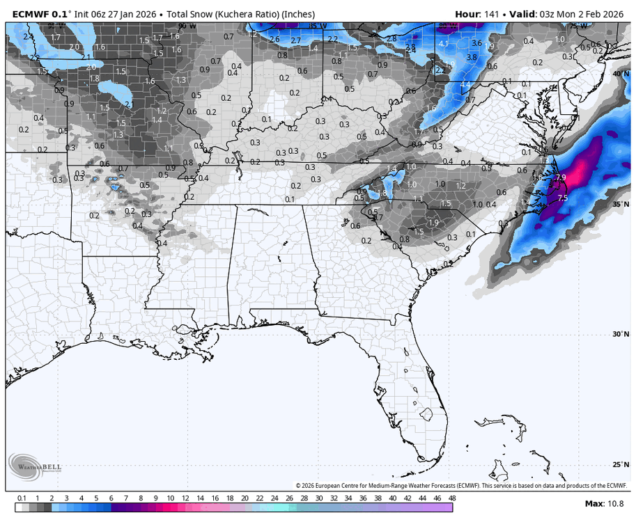
-
Possible coastal storm centered on Feb 1 2026.
Baroclinic Zone replied to Typhoon Tip's topic in New England
Euro is a moose fart away from nailing eastern areas. -

The Jan 31 Potential: Stormtracker Failure or 'Tracker Trouncing
Ji replied to stormtracker's topic in Mid Atlantic
I think the GFS has a better handle on this. It was made for this type of storm. -

Richmond Metro/Hampton Roads Area Discussion
chris624wx replied to RIC Airport's topic in Mid Atlantic
That's from the 12z run. Though, doesn't look much different than that at 0z -
The Jan 31 Potential: Stormtracker Failure or 'Tracker Trouncing
Solution Man replied to stormtracker's topic in Mid Atlantic
We got it -

The Jan 31 Potential: Stormtracker Failure or 'Tracker Trouncing
bncho replied to stormtracker's topic in Mid Atlantic
Yes, it'll probably be a trend like @Terpeaststated. -
 Won't it take a few runs for the models to really get a handle on the new data?
 -
West of 12z, basically in line/slightly east of 18z


