All Activity
- Past hour
-

Feb 22nd/23rd "There's no way..." Storm Thread
Interstate replied to Maestrobjwa's topic in Mid Atlantic
Yep... it doesn't take long to know where the model is going to go. It happens early -

“Cory’s in NYC! Let’s HECS!” Feb. 22-24 Disco
ineedsnow replied to TheSnowman's topic in New England
confluence is less -

“Cory’s in NYC! Let’s HECS!” Feb. 22-24 Disco
SouthCoastMA replied to TheSnowman's topic in New England
should be better due to less shit streaking north of us..but that's the extent of my long range NAM analysis -

Central PA Winter 25/26 Discussion and Obs
WmsptWx replied to MAG5035's topic in Upstate New York/Pennsylvania
That dude's entire life was a lie. -

Feb 22nd/23rd "There's no way..." Storm Thread
stormtracker replied to Maestrobjwa's topic in Mid Atlantic
And out to sea it goes on the NAM. -
“Cory’s in NYC! Let’s HECS!” Feb. 22-24 Disco
ineedsnow replied to TheSnowman's topic in New England
looks like 6z 12z didn't even have a storm -

Feb 22nd/23rd "There's no way..." Storm Thread
SnowenOutThere replied to Maestrobjwa's topic in Mid Atlantic
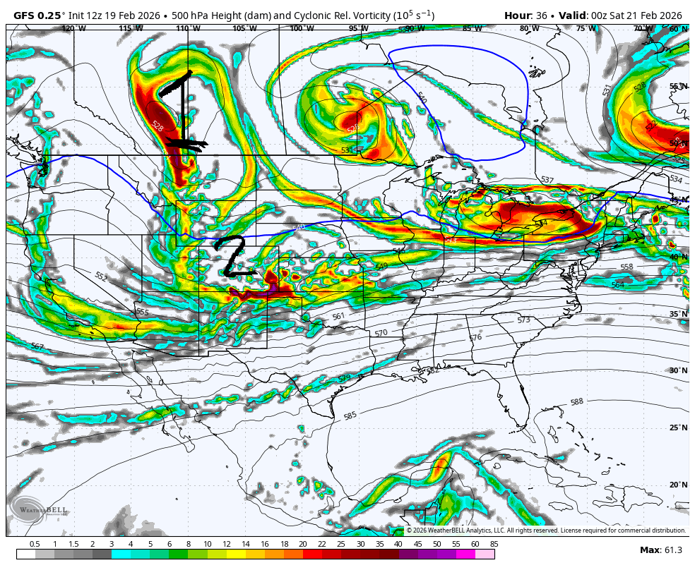
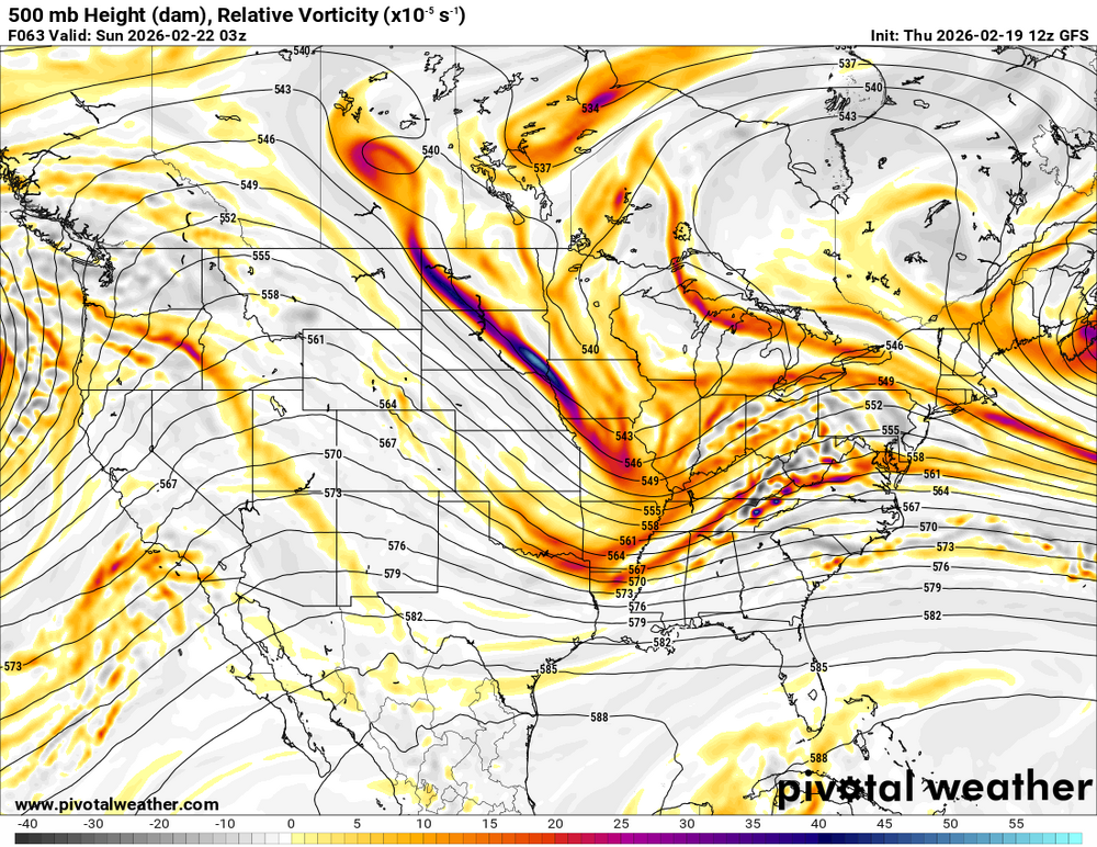
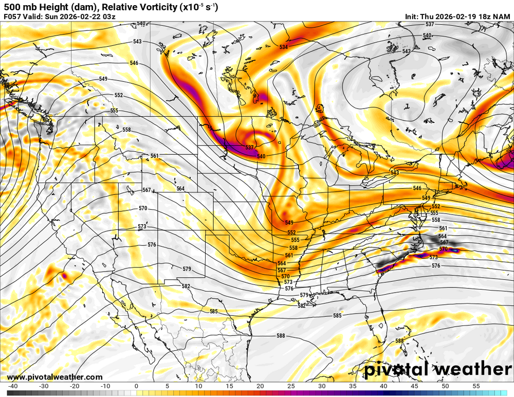
To show what I mean we gotta watch how the vort dropping out of Canada interacts with the vort coming out of the SW. Lets take the GFS as an example of our two important players. In my opinion these are the main things we need to watch to see if anything close to the GFS will happen. Vorticity lobe 1 is the main factor IMO, so lets focus on that in comparison to the Euro This is merely at hour 36 but we can also see the seeds for why the Euro sucks. The NS lobe is angled worse, and the SW is being chopped in half by the NS and not phased. Now lets run this forward By hour 51 the writing is on the wall Night and day difference with the NS handling. The GFS stretches it out and begins positively interacting with the vorticity of player 2 (our SW); meanwhile, the Euro balls up the NS and lets the SW go it alone. This results in it being unable to capture our surface low latter. By the 72 hour mark the differences which began within a day and a half come to roost. The GFS has one consolidated system with the NS stretched lobe helping amplify the SW energy and the Euro instead has two separate vort maxes. Since this initial deviation is now within a day and a half I expect it to be resolved by 18z tonight... where the GFS probably gives a half cave to the Euro.
-

Feb 22nd/23rd "There's no way..." Storm Thread
Maestrobjwa replied to Maestrobjwa's topic in Mid Atlantic
If it's wrong the moonwalk backwards is gonna be epic, lolol -

Feb 22nd/23rd "There's no way..." Storm Thread
Cobalt replied to Maestrobjwa's topic in Mid Atlantic
Rufus looks more amped through 60 hours than 12z -

E PA/NJ/DE Spring 2026 Obs/Discussion
Birds~69 replied to PhiEaglesfan712's topic in Philadelphia Region
No clue but if this storm fails badly way below normal snow wise Feb and kinda meh in temps. About average temps when all is said and done and shitty snow wise? That's a C-...need to get on the horn and yell at someone! Back to blizzard coverage... 41F/Oh yeah, overcast
-
NAM is crap for CT
-

Feb 22nd/23rd "There's no way..." Storm Thread
87storms replied to Maestrobjwa's topic in Mid Atlantic
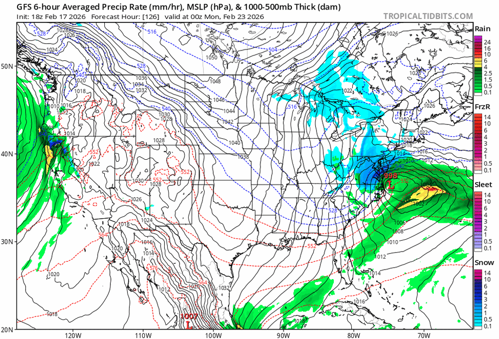
Seems like every model wants to pop a legit coastal. The problem is gfs is like 150 miles west of the consensus. -
Like 7 straight runs of west shifts lol
-

“Cory’s in NYC! Let’s HECS!” Feb. 22-24 Disco
Kitz Craver replied to TheSnowman's topic in New England
Looks bad to me.. lol -
such little differences make a difference between 33 inches of snow and 3 lol
-
Feb 22nd/23rd "There's no way..." Storm Thread
stormtracker replied to Maestrobjwa's topic in Mid Atlantic
Gotcha. But yeah, it's closer to the Euro than GFS so far -
I meant between it and the GFS. Strength and location of features are almost identical, minus the one that really matters over the Dakotas and Nebraska.
-
“Cory’s in NYC! Let’s HECS!” Feb. 22-24 Disco
Kitz Craver replied to TheSnowman's topic in New England
La-la lock it up! -
Feb 22nd/23rd "There's no way..." Storm Thread
stormtracker replied to Maestrobjwa's topic in Mid Atlantic
Yup, but it's not the same as Euro or GFS, but will be more Euro than GFS at this point. -

Feb 22nd/23rd "There's no way..." Storm Thread
Jake Wx replied to Maestrobjwa's topic in Mid Atlantic
so real it take forever to come out -
A hail mary shot in elevated Eastern areas this weekend. Severe thread may have some activity. Otherwise, spring-like weather as we close February and begin March.
-

Feb 22nd/23rd "There's no way..." Storm Thread
Weather Will replied to Maestrobjwa's topic in Mid Atlantic
NAM runs on an Odyssey game station platform it is so slow.... -

Feb 22nd/23rd "There's no way..." Storm Thread
SomeguyfromTakomaPark replied to Maestrobjwa's topic in Mid Atlantic
Little bit higher heights out front, little bit more interaction between streams over the upper midwest. -
Feb 22nd/23rd "There's no way..." Storm Thread
stormtracker replied to Maestrobjwa's topic in Mid Atlantic
It's definitely not the same vs 12z run. It doesn't look like either the GFS or Euro. Maybe something in between -
Feb 22nd/23rd "There's no way..." Storm Thread
SnowenOutThere replied to Maestrobjwa's topic in Mid Atlantic
NAM will be solidly in the EURO camp. Differences occur by hour 36 between GFS and Euro