All Activity
- Past hour
-
Snow showers or a period of snow is likely tomorrow. A coating to an inch of snow is likely in and around New York City, as readings will likely be above freezing for most or all of the event. The precipitation could mix with or even change to rain in New York City. Total QPF will probably be close to 0.20". The distant northern and western suburbs could see 1"-2" of snow with some locally higher amounts due to slightly higher QPF and slightly colder temperatures. Highs will likely reach the upper 30s to near 40°. It will then turn colder following the light precipitation. Additional flurries or snow showers are possible on Sunday. A coastal storm could begin to develop off the Southeast coast and then track south and east of the 40N-70W benchmark. On such a track, this developing storm could bring a period of accumulating snow to eastern Long Island into southeastern New England on Sunday into Sunday night. There remains a degree of uncertainty concerning the storm's track and rate of development. Highs will be mainly in the lower and middle 30s in New York City on Sunday and Monday. Arctic air will move into the region on Monday night. Tuesday could be the coldest day so far this season with highs struggling to reach the lower 20s and lows well into the teens in New York City. Suburban areas could see single-digit lows. Wednesday will be another unseasonably cold day. Temperatures will remain below normal through at least most of next week. After January 20th, conditions could become more favorable for snowfall, as a generally cold pattern continues. The probability of a PNA+ regime has continued to increase. PNA-related developments would have large implications for snowfall. A persistently positive PNA would have above climatological risk of moderate or significant snowfalls. A mainly negative PNA would favor mainly small snowfalls. The ENSO Region 1+2 anomaly was -0.7°C and the Region 3.4 anomaly was -0.8°C for the week centered around January 7. For the past six weeks, the ENSO Region 1+2 anomaly has averaged -0.47°C and the ENSO Region 3.4 anomaly has averaged -0.67°C. La Niña conditions will likely continue into at least late winter. The SOI was +21.96 today. The preliminary Arctic Oscillation (AO) was -1.350 today. The PNA was +0.965. That's its highest figure since November 2, 2025 when it was +1.071. Based on sensitivity analysis applied to the latest guidance, there is an implied near 62% probability that New York City will have a cooler than normal January (1991-2020 normal). January will likely finish with a mean temperature near 33.0° (-0.7° below normal). Supplemental Information: The projected mean would be 0.4° above the 1981-2010 normal monthly value.
-
BEST STORM THREAD EVER
-
We might be making a 4th quarter comeback.
-

Jan 17-18 Sunday Funday Storm
WinstonSalemArlington replied to NorthHillsWx's topic in Southeastern States
Alan Huffman -

Storm potential January 17th-18th
wthrmn654 replied to WeatherGeek2025's topic in New York City Metro
It's a 3 day weekend, probably doing incase they don't come in Monday. -
Rgem for both events
.thumb.png.cfcfb58377d3eaf827a47ca0d54cbeb0.png)
-
This thing may not be dead yet lol
-
Alright kids, 00z is where we put all our chips in
-

First Legit Storm Potential of the Season Upon Us
ineedsnow replied to 40/70 Benchmark's topic in New England
18z Reggie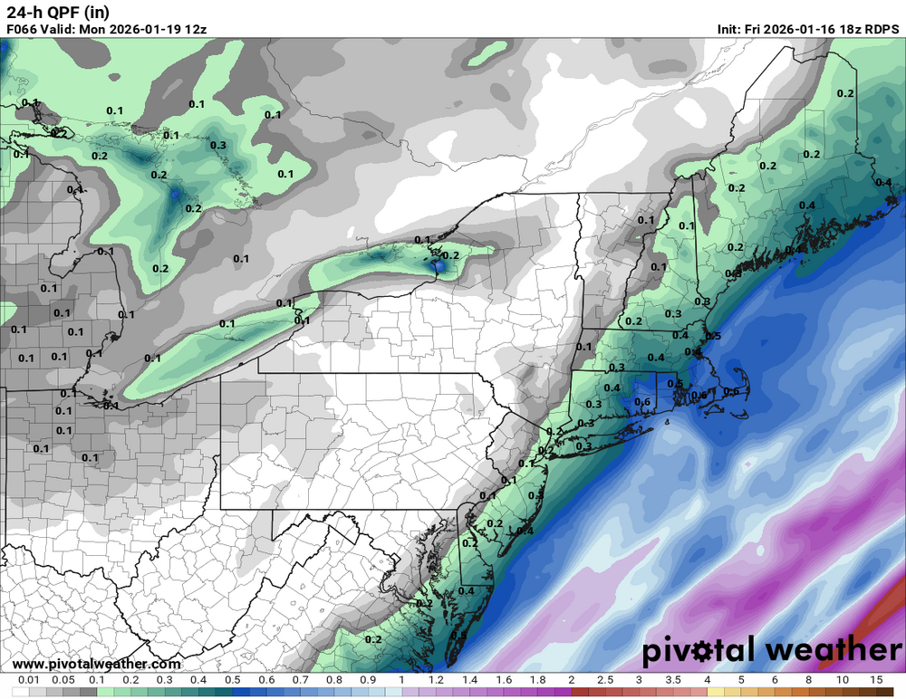
-

Storm potential January 17th-18th
Brian5671 replied to WeatherGeek2025's topic in New York City Metro
We have that BS here too-the roads are never done as well on weekend events. Too warm here for this one, wet roads -
.thumb.png.4150b06c63a21f61052e47a612bf1818.png)
First Legit Storm Potential of the Season Upon Us
HIPPYVALLEY replied to 40/70 Benchmark's topic in New England
WOR needs to lay down an inch or two tomorrow because I think Monday is a no go this far inland. I could envision some scenario where Dave and Ineedafix get a couple tomorrow and then some MLM if the 2nd system tics a little closer. -
First Legit Storm Potential of the Season Upon Us
ineedsnow replied to 40/70 Benchmark's topic in New England
Maybe even increased a bit -
First Legit Storm Potential of the Season Upon Us
ineedsnow replied to 40/70 Benchmark's topic in New England
18Z RGEM about the same as 12z -
Flurries imby fwiw
-
RGEM looks similar to the NAM.
-
First time I’ve ever been excited to be in that zone
-

First Legit Storm Potential of the Season Upon Us
weatherwiz replied to 40/70 Benchmark's topic in New England
If we can get that vort better this would take off...and hell maybe the AIs are really out that prospect. But even looking at the GFS and how the we get a developing jet stream lifting poleward...you get quicker pressure falls at the sfc and the low to pop right along or near the Carolina coast, this thing probably tracks close to the benchmark. It might be a big ask but it really isn't far off from being a reality. -
Jan 17-18 Sunday Funday Storm
WinstonSalemArlington replied to NorthHillsWx's topic in Southeastern States
-

Storm potential January 17th-18th
ForestHillWx replied to WeatherGeek2025's topic in New York City Metro
My guess it’s more so the town paying OT to plow/salt the lot; but the point remains. -

First Legit Storm Potential of the Season Upon Us
wxsniss replied to 40/70 Benchmark's topic in New England
Agree, could be both at play AIs are fuzzy/probabilistic at H5 (potentially a weakness or a strength depending on context), but here's a comparison of 12z runs today, for Monday 0z timepoint... AIGFS does have significantly better tilt that could be responsible for northwest extent of QPF... and it also seems to have an overdone spread of QPF (also to eastern extent) in comparison to legacy GFS: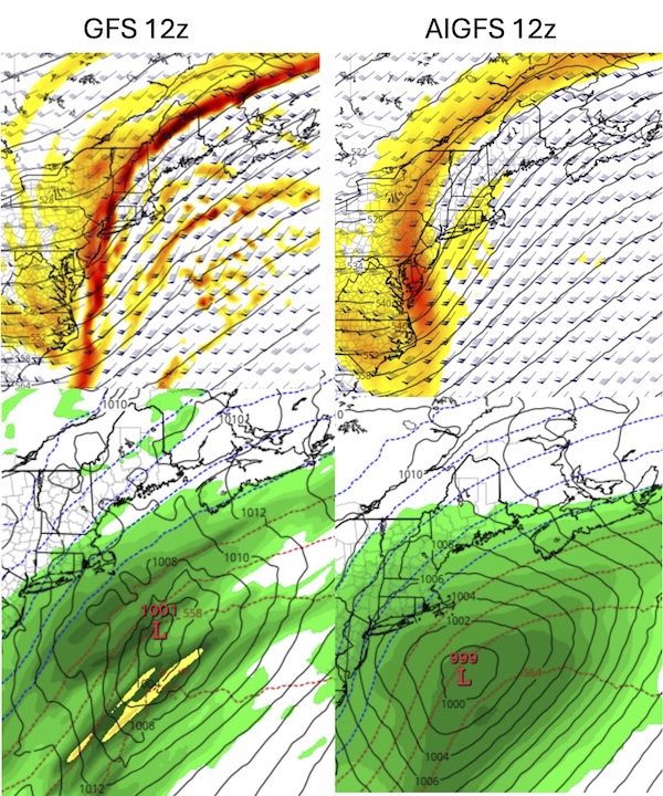
-

Storm potential January 17th-18th
the_other_guy replied to WeatherGeek2025's topic in New York City Metro
absolutely. Im in one of those areas. But most people in this forum are getting zero accumulating snow. And then we read about bad models. No. Just wishcasting. First storm is an elevation storm. Second storm is in the same spot it has been for days. Offshore. -
First Legit Storm Potential of the Season Upon Us
HIPPYVALLEY replied to 40/70 Benchmark's topic in New England
I’m thinking maybe a Weedwhacker or edging tool this weekend. -
I’m out in ellinwood white land so I would disagree
-

First Legit Storm Potential of the Season Upon Us
Sey-Mour Snow replied to 40/70 Benchmark's topic in New England
Desperate times call for desperate measures, the RRFS is much farther west gets accumulating snow to river close to warning SEMASS -
1-2” would make me ecstatic.


.png.c372ab68f3418be00745cd98fce6add5.png)


