All Activity
- Past hour
-
HAFS still get this to 140kt+ at 00z so I would look at the Euro with some skepticism tonight. It’s all about the track though.
- Today
-
Impressive presentation over the past few hours.
-
If this is realistic, it could mean that the W 1/2 of Jamaica is saved from as devastating a blow as earlier feared although there’d still be extremely heavy rainfall especially in SE Jamaica along with the devastating consequences of that in that portion of the island.
-
The favorable conditions really collapse on tonight's Euro once Melissa gets to Jamaica.
-
BULLETIN Tropical Storm Melissa Intermediate Advisory Number 15A NWS National Hurricane Center Miami FL AL132025 200 AM EDT Sat Oct 25 2025 ...AIR FORCE HURRICANE HUNTER DATA SUGGEST MELISSA IS ALMOST A HURRICANE... ...LIFE-THREATENING AND CATASTROPHIC FLASH FLOODING AND LANDSLIDES EXPECTED IN PORTIONS OF SOUTHERN HISPANIOLA AND JAMAICA THROUGH THE WEEKEND... SUMMARY OF 200 AM EDT...0600 UTC...INFORMATION ---------------------------------------------- LOCATION...16.3N 74.9W ABOUT 170 MI...275 KM SE OF KINGSTON JAMAICA ABOUT 235 MI...375 KM SW OF PORT AU PRINCE HAITI MAXIMUM SUSTAINED WINDS...70 MPH...110 KM/H PRESENT MOVEMENT...NW OR 315 DEGREES AT 3 MPH...6 KM/H MINIMUM CENTRAL PRESSURE...986 MB...29.12 INCHES
-
Also, the 0Z Euro is not nearly as strong as prior runs with 968 mb the strongest when 35 miles S of C Jamaica at hour 54. Then it landfalls at hour 72 at 982 before a sharp turn ENE to E tip at 992. That is a change in the heading from NE across the island on prior runs. Rainfall is still torrential in E Jamaica with 18” at Kingston.
-
Tonight's hurricane models (HWRF, HMON, HAFS) are no longer showing Melissa moving toward the west to the south of Jamaica. They are all now moving the center nw to wnw into eastern Jamaica.
-
Hey look it's a UFO
-

Spooky Season (October Disco Thread)
WinterWolf replied to Prismshine Productions's topic in New England
That’s because we don’t know. LMFAO. -
987 mb That should be the final recon pass until morning.
-
Yeah no recent microwave passes to confirm. Still, this is probably the most robust it’s looked yet.
-
Gfs/icon still east of envelope.
-
Launched a weather balloon today for my atmosphere and weather class!

-
Melissa is trying with this new eruption of convection. Still too early to tell if this is improving the structure under the hood
-

Spooky Season (October Disco Thread)
Torch Tiger replied to Prismshine Productions's topic in New England
Too confusing -
Tropical Storm Melissa Discussion Number 15 NWS National Hurricane Center Miami FL AL132025 1100 PM EDT Fri Oct 24 2025 Reports from NOAA and Air Force Reserve Hurricane Hunter aircraft indicate that Melissa is still trying to get organized. While the central pressure has fallen to 993 mb, the tail Doppler radar data from the NOAA aircraft shows that the 500-mb center is displaced about 20-25 n mi east-southeast of the surface center. The tilt is also present at the aircraft flight levels, with dropsondes released at the flight-level center missing the surface center and reporting 25-35 kt surface winds. In addition, the aircraft radar data and land-based radar data from Jamaica show that the cyclone has not yet been able to develop a persistent eyewall. Based mainly on the central pressure and satellite intensity estimates the initial intensity is held at 55 kt. Although the initial motion is a bit uncertain, Melissa now appears to be moving slowly northwest with the initial motion 325/3 kt. A turn toward the west or west-northwest and a continued slow forward speed are expected in 12-24 h as low- to mid-level ridging builds to the north of the cyclone. This motion should continue through about 72 h. After that time, a deep-layer mid-latitude trough moving into the southeastern United States and the southwestern Atlantic will break the ridge to the north, with Melissa expected to turn northward and eventually northeastward as it recurves into the westerlies. There remains a substantial spread in the guidance with respect to where the center of Melissa may pass in relation to Jamaica, with solutions ranging from the GFS passing near the eastern end of the island to the Canadian passing west of the island. The new forecast track is similar to the previous track and shows the center passing over Jamaica just after 72 h. However, any motion north of the current forecast track could bring the center near or over Jamaica at almost any time between 24-72 h. After passing Jamaica, Melissa is likely to move near or over eastern Cuba, but which portion of eastern Cuba may be most affected remains uncertain at this time. While the westerly shear that has been affecting Melissa will not completely stop during the next 2-3 days, it is forecast to decrease to about 10-15 kt in 24 h or less. This should allow rapid development as the storm is located in a moist environment over very warm sea surface temperatures. The one short-term restraining factor is that Melissa's structure is not quite good enough yet to allow rapid intensification (RI), and thus it could be another 6-12 h before RI begins in earnest. The latest round of intensity guidance shows somewhat lower peak intensities than the previous advisory, mainly due to the models moving Melissa near or over Jamaica. However, the current forecast track keeps the center offshore for 72 h or more, and based on this the new intensity forecast is at the high end of the guidance with a peak intensity of 135 kt. Despite the weaker guidance, there is still a possibility that Melissa could become a category 5 hurricane during the forecast period. After passing near or over Jamaica, the cyclone is forecast to weaken due to possible interaction with Cuba and increasing southwesterly shear as Melissa encounters the mid-latitude westerlies. Key Messages: 1. Jamaica: Melissa’s slow movement will bring a multi-day period of damaging winds and heavy rainfall beginning late Saturday or Sunday, likely causing catastrophic flash flooding and numerous landslides. There is an increasing risk of life-threatening storm surge early next week. All preparations should be complete by late Saturday. 2. Haiti: Catastrophic flash flooding and landslides are expected across southwestern Haiti into early next week, likely causing extensive infrastructural damage and potentially prolonged isolation of communities. Immediate preparations to protect life and property are urged. Strong winds could also potentially last for a day or more over the Tiburon peninsula. 3. Dominican Republic: Heavy rainfall could produce potentially catastrophic flash flooding and numerous landslides in southern regions. 4. Eastern Cuba, Bahamas, and the Turks and Caicos: Monitor Melissa closely. There is an increasing risk of a significant storm storm surge, damaging winds, and heavy rainfall by the middle of next week. In eastern Cuba, the risk of life-threatening flash flooding and landslides is increasing. FORECAST POSITIONS AND MAX WINDS INIT 25/0300Z 16.1N 74.9W 55 KT 65 MPH 12H 25/1200Z 16.5N 75.2W 65 KT 75 MPH 24H 26/0000Z 16.7N 75.7W 85 KT 100 MPH 36H 26/1200Z 16.8N 76.2W 105 KT 120 MPH 48H 27/0000Z 16.8N 76.8W 120 KT 140 MPH 60H 27/1200Z 16.9N 77.5W 135 KT 155 MPH 72H 28/0000Z 17.4N 77.6W 135 KT 155 MPH 96H 29/0000Z 19.3N 76.6W 115 KT 130 MPH 120H 30/0000Z 23.2N 73.7W 90 KT 105 MPH $$ Forecaster Beven
-
Wonder if tonight (or the next few hours at least) may be a case of arrested development where there are very high cloud tops and intense convection but the storm isn't quite stacked enough to take advantage of it.
-

Central PA Fall Discussions and Obs
canderson replied to ChescoWx's topic in Upstate New York/Pennsylvania
They are on border of a yellow county and had rain all summer. -
We are about to have a little fun with this puppy https://radar.weather.gov/station/kewx/standard Those pinks and whites are likely going to hit Buda head on. While you guys get to chill out with some cool weathers.
-
Spooky Season (October Disco Thread)
WinterWolf replied to Prismshine Productions's topic in New England
Could the nor’easter phase with the cane? -

Central PA Fall Discussions and Obs
Jns2183 replied to ChescoWx's topic in Upstate New York/Pennsylvania
How is your family holding up with the ongoing awful drought? Sent from my SM-G970U1 using Tapatalk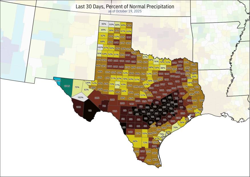
-

Spooky Season (October Disco Thread)
Diggiebot replied to Prismshine Productions's topic in New England
Get this passed Jamaica. The timing is so key. The pattern screams close pass or capture. The nor’easter makes it so hard to differentiate systems. Are the models showing the nor’easter hit as a mask for the capture? -
Central PA Fall Discussions and Obs
Jns2183 replied to ChescoWx's topic in Upstate New York/Pennsylvania
Nighttime QLCS nightmare Sent from my SM-G970U1 using Tapatalk -
Shear is modeled to relax significantly. There may still be some light mid-level shear, but not enough to prevent a major hurricane given other environmental features. The real key here is the eventual position of the center when the steering currents change. Land interaction will be the only significant deterrent to high-end intensity, such as where Melissa is positioned when it begins the slow turn north. Upwelling isn't going to be much of a factor until it has already reached MPI, if Melissa goes through a stall or slow crawl during its northward turn, as OHC is deep in that part of the Caribbean.