All Activity
- Past hour
-

November 2025 general discussions and probable topic derailings ...
alex replied to Typhoon Tip's topic in New England
While not as cold as it has been, today is the first time I’ve noticed wetlands and small ponds are completely covered in ice. -

November 2025 general discussions and probable topic derailings ...
CoastalWx replied to Typhoon Tip's topic in New England
Yep Fall is right around the corner. -
 Made it down to 26.1°. Not as cold as Oct 10th, but still pretty chilly. I suppose winter is on its way.
 -
Many have been posting daily about how much they miss you when you’re not here to light our darkness.
-
November 2025 general discussions and probable topic derailings ...
CoastalWx replied to Typhoon Tip's topic in New England
Congrats NNE -
November 2025 general discussions and probable topic derailings ...
alex replied to Typhoon Tip's topic in New England
Stayed cloudy a good chunk of the night so only made it down to 24F. Nice to see the sun this morning! -
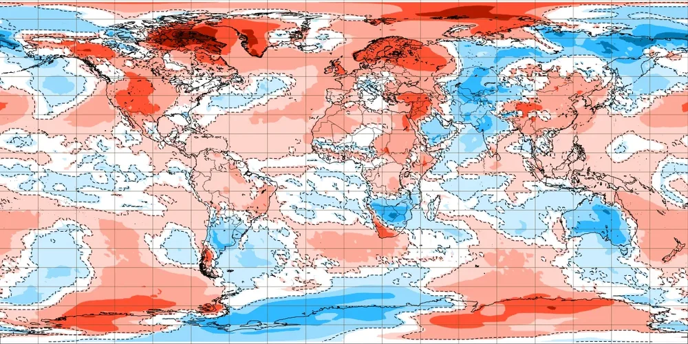
The Northeast Pacific continues to cool, the “blob” area has cooled over -1.25C since September 1st. While these SSTs are not driving the pattern, it’s indicative of a longwave pattern that favors cooling in that area. If we get to 11/30 with no sign of this trend completely reversing, it’s going to become very difficult for people to continuing using years that saw SST patterns with a “warm blob”. To clarify, I’m only speaking of the people who are using SST analogs with warm blobs, not other factors (QBO, solar, PDO, AMO, etc.) to justify certain analogs
-
Disaster injury, disaster defense, disaster game. This team is 180° opposite last year. Can only blame injuries so much. Other teams have them and don’t look anywhere as awful. If the D coordinator isn’t fired this week they just don’t care about saving the season
-
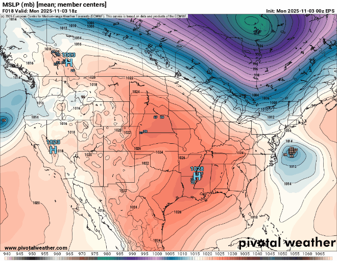
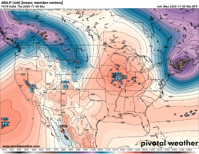
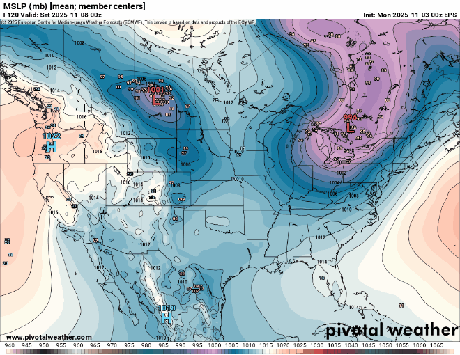
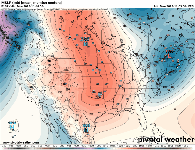
Very fast Northern Stream pattern continues into November. A storm system cutting through or north of the Great Lakes every few days. Tough to get much in the way of coastal storm development as we have seen in recent years. So we get warm-ups ahead of the lows and cool-downs behind. But no significant cold for this time of year due to such a strong Pacific influence. North America is very warm for this time of year and all the real cold is over in Siberia. This contrast between the record SSTs in the North Pacific drives the fast Pacific Jet. November 3 to 10 EPS forecast
-
The IOD is peaking right now. It’s at -1.94 through 11/2 and expected to peak by 11/10. With the ongoing cooling in the WIO and warming in the EIO, I expect it to bottom out on the next weekly update at or slightly below -2.
-
 Ineedsnows snower disappeared next week
 -
They led the way on Helloween. Even tonight into tomorrow looks like 40-45 mph gusts
-

November 2025 general discussions and probable topic derailings ...
Modfan2 replied to Typhoon Tip's topic in New England
Yup, down to 29F down here before the clouds rolled in -
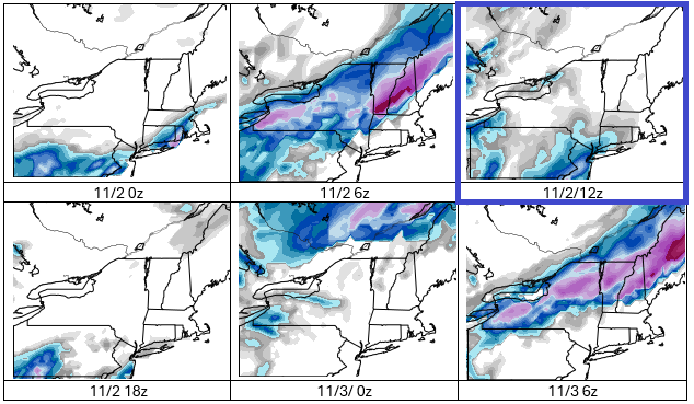
Aside from the 11/2 12z run of the GFS, the GFS is not showing an early season snowstorm in the New York City area. Outlier events typically do not verify when they lack support. So far, there is very little support on either the EPS or GEFS for the kind of snowstorm one run of the GFS showed yesterday. In general, one should wait for support to develop and run-to-run continuity to develop before embracing outlier events. The probability of the kind of event for New York City and its immediate suburbs shown yesterday remains low. More likely is a cold rain event with highs in the 40s with perhaps some flakes mixed in, though the mixing remains uncertain at this time. A better chance of snow exists for parts of the Poconos, Catskills, Adirondacks, and central/northern New England, which would include parts of Dutchess and Orange Counties.
-
.thumb.png.4150b06c63a21f61052e47a612bf1818.png)
November 2025 general discussions and probable topic derailings ...
HIPPYVALLEY replied to Typhoon Tip's topic in New England
28F for the low here. Been some chilly mornings, the past few weeks. -
With the Vue I also noticed that issue common with home weather stations where it downpours the rain totals were a bit high. Did you notice that at all? Both those issues were annoying to me so I saved up and got the Davis Vantage Pro2 and haven looked back since both those issues went away. As a result, there’s a period of 6 or so years in my records where I have to take the high temps I recorded with a grain of salt, it’s evident in my records. 32 for the low here earlier, 34 now under gray skies.
-

November 2025 general discussions and probable topic derailings ...
Lava Rock replied to Typhoon Tip's topic in New England
35f. Denied again Sent from my SM-S921U using Tapatalk -
Is been discussed so many times on here. Historically, its true
-

November 2025 general discussions and probable topic derailings ...
dendrite replied to Typhoon Tip's topic in New England
25.9° Coldest so far -
November 2025 general discussions and probable topic derailings ...
CoastalWx replied to Typhoon Tip's topic in New England
Yeah for sure. At least if those models are right. NAM not as enthused. -

November 2025 general discussions and probable topic derailings ...
BrianW replied to Typhoon Tip's topic in New England
.thumb.png.8673e7a3de18aa42a86602c66a5b9286.png)
- Today
-
 30F. Meh. Yesterday was colder
 -
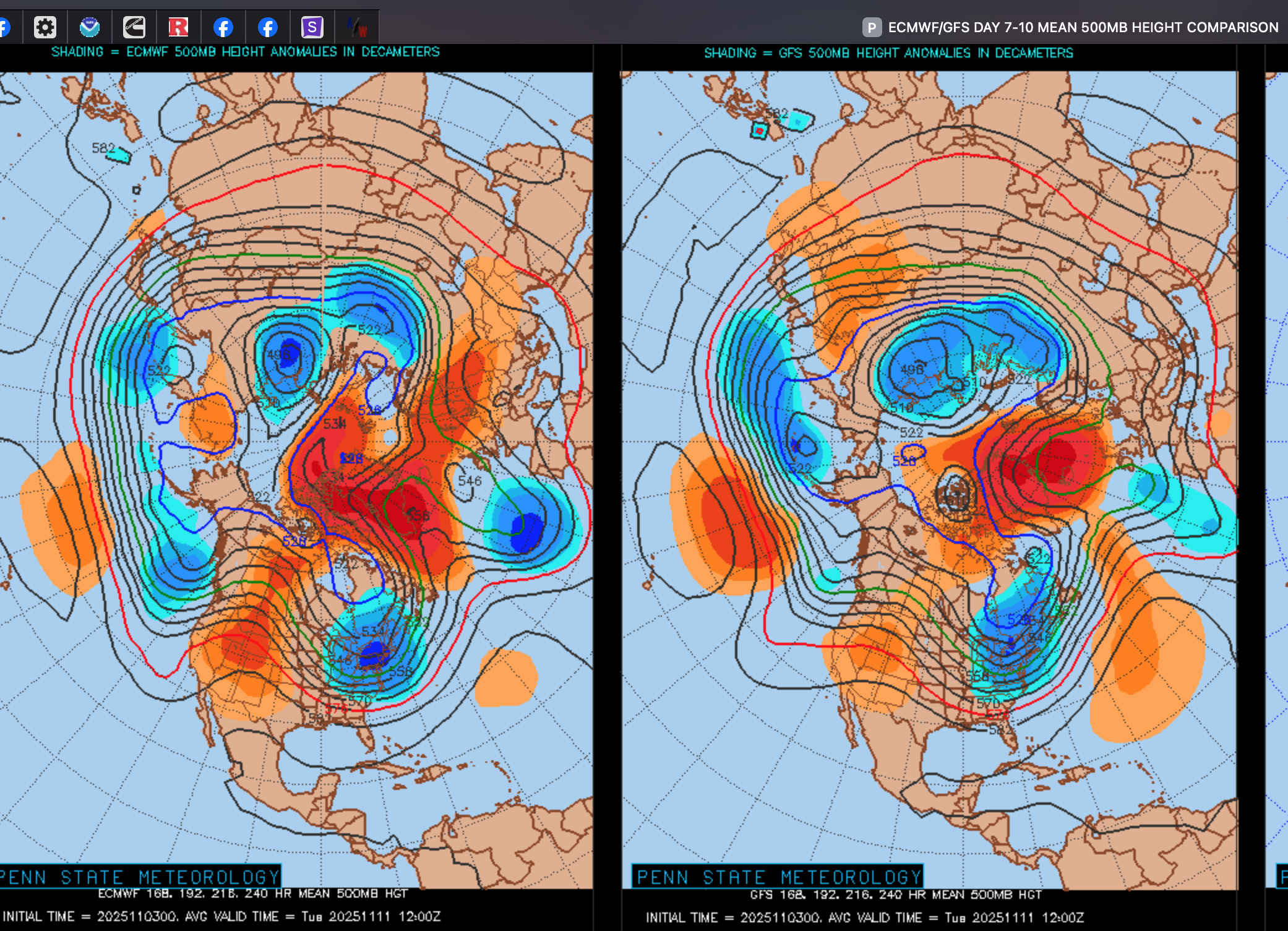
I need to make a correction to my stmt 2 days ago: "block now gone". The block reforms Greenland and northern Canada Thursday (6th) onward and should linger through at least the 15th I need to keep two things in mind... 1) it's further N than the one we just finished this past week so still looks like N of 40N lows (not pressing storm track far enough south) 2) NO southern streamer short wave so far and so I think we're going to need the block to depress (relocate further s than now projected). We need the southern streamer for a coastal low Am looking to sometime between Sun Nov 9-Thursday Nov 13 for a first possible widespread minor snow cover, on grass, INLAND II84 corridor. Not unusual for first time in Nov. I liked Don's snow stats through Nov 15 in CP... but for now I cant see anything more than a T in the air if we get lucky. In the meantime: sort of looks to me like a wind advisory event Wed night-Thu morning Nov 5-6 Subsequently maybe a BLOWOUT tide Thursday morning? I added the 7-10day 00z/3 MEAN 5H.. block evident but a little far north, I think.

-
November 2025 general discussions and probable topic derailings ...
BrianW replied to Typhoon Tip's topic in New England
Yeah. We still grow with BDR at 44. There still hasn't been anything close to a frost here...thumb.png.d4c74478c0c0cd3f8547144205d9a03c.png)
-
Stronger rips than Helloween night?


.png.cc8bba658d250b640b7cd5768a384499.png)

.png.c4786aba69bc24817fa158ee61ca626a.png)