All Activity
- Past hour
-
Feel VERY confident this has trended to just a rip current/beach erosion threat. Bermuda still needs to watch
-
So you're saying there's a chance?
-
The Euro is just another model. Nowhere near its glory of a decade ago lol. With a well defined center now and slower motion, along with a weaker SE cutoff and stronger Humberto, it’s harder to see that escape route being closed.
-
What is a Chlorine Oxide Radical?
-
She's just trying to fit in with the crowd.
-

September 2025 OBS-Discussion centered NYC subforum
psv88 replied to wdrag's topic in New York City Metro
81. .03 -
Unlike prior two runs, the 0Z Euro stays away from US. Also, unlike some hurricane model runs yesterday that curved back into SC/GA, the 0Z runs all stayed offshore that area.
-
I never go against the Euro.
-
Finished up with 1.02... By far the biggest event since back in July... Solid past 2 weeks down here...
- Today
-
19-20 had a DJF ONI of +0.5c. Our last Weak Nina was 22-23 (-0.7 ONI), and arguably last Winter because the RONI was close to -1.0c.
-

2025-2026 ENSO
40/70 Benchmark replied to 40/70 Benchmark's topic in Weather Forecasting and Discussion
I think about 125 points and up is considered above normal.....so add another feather in the cap of poleward Aleutian riding this season if that indeed comes to fruition. -

2025-2026 ENSO
Stormchaserchuck1 replied to 40/70 Benchmark's topic in Weather Forecasting and Discussion
It was a little telling that NOAA put out a forecast for 13-19 NS earlier in the season... they usually don't bust that bad. They had 18-25 last year, which looked like it was going to be way off mid-season then we came back at the end and hit the range. -
Euro pretty much on an island
-
0Z UKMET: stays OTS like every other UKMET and every Icon has done. Reminder: Coincidentally or not, the UKMET and Icon were the two best models by far for Ian by being the furthest to the right/SE coming into SW FL. 0Z UKMET ROPICAL DEPRESSION 09L ANALYSED POSITION : 22.0N 76.4W ATCF IDENTIFIER : AL092025 LEAD CENTRAL MAXIMUM WIND VERIFYING TIME TIME POSITION PRESSURE (MB) SPEED (KNOTS) -------------- ---- -------- ------------- ------------- 0000UTC 28.09.2025 0 22.0N 76.4W 1005 31 1200UTC 28.09.2025 12 23.2N 76.9W 1003 35 0000UTC 29.09.2025 24 24.6N 76.7W 1000 32 1200UTC 29.09.2025 36 26.7N 77.1W 998 43 0000UTC 30.09.2025 48 28.5N 77.4W 994 42 1200UTC 30.09.2025 60 29.2N 77.3W 991 38 0000UTC 01.10.2025 72 29.0N 75.9W 989 41 1200UTC 01.10.2025 84 29.7N 73.4W 987 47 0000UTC 02.10.2025 96 30.3N 69.6W 985 57 1200UTC 02.10.2025 108 31.6N 64.5W 984 54 0000UTC 03.10.2025 120 33.5N 59.8W 986 67 1200UTC 03.10.2025 132 34.8N 57.0W 992 48 0000UTC 04.10.2025 144 36.3N 56.0W 995 43 1200UTC 04.10.2025 156 37.7N 54.4W 999 39 0000UTC 05.10.2025 168 41.4N 49.5W 999 41
-
00z GFS is well out to sea. Oh well?
-

E PA/NJ/DE Autumn 2025 Obs/Discussion
JTA66 replied to PhiEaglesfan712's topic in Philadelphia Region
Makes sense. The winter of 1984-85 was extremely cold here in SE PA, but snow wise, it was mainly nickel & dime events. Suppression sounds about right. -
Sure ain’t something you see everyday
-
2025-2026 ENSO
40/70 Benchmark replied to 40/70 Benchmark's topic in Weather Forecasting and Discussion
Yea, no harm.....happens to all of us. I admire that you put yourself out there. -
2025-2026 ENSO
40/70 Benchmark replied to 40/70 Benchmark's topic in Weather Forecasting and Discussion
Oh, Paul Roundy...wow. You're in good hands. -
Wouldn't a slower storm interact with the high pressure system over NE Canada moving in and steer it west like Sandy?
-
I agree but the short term motion prior to any Fujiwara was also very wrong on those models. Nome of them has this thing stalled out in the southern Bahamas and near Cuba for 2-3 days straight
-
Thanks. Everyone’s wrong sometime, even you who has often been right. And 100+ isn’t a guarantee yet.
-

2025-2026 Fall/Winter Mountain Thread
Maggie Valley Steve replied to Buckethead's topic in Southeastern States
Breathe easy neighbors. I like our chance tonight. Cold air is coming!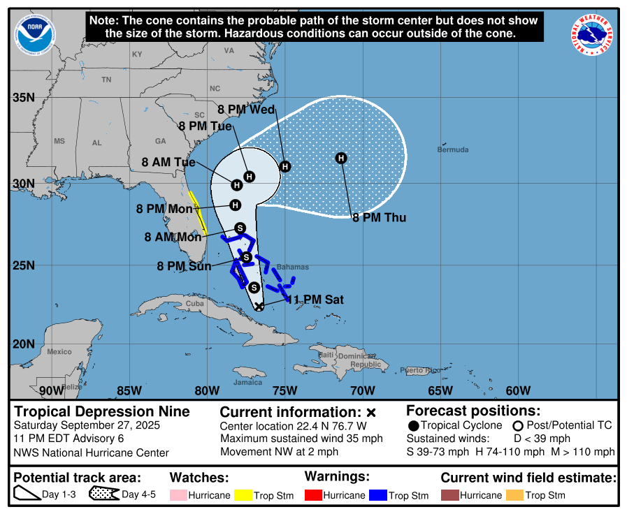
-
0.70" looks like another moderate batch of showers might roll through before it tapers off.
-
Ok? So if I’m wrong I’m wrong. Congrats


