All Activity
- Past hour
-

Feb 22nd/23rd "There's no way..." Storm Thread
balltermen replied to Maestrobjwa's topic in Mid Atlantic
I think you'll score. but maybe 3-6" instead of the largest snowstorm on record at DCA that the GFS depicts. -

Feb 22nd/23rd "There's no way..." Storm Thread
clskinsfan replied to Maestrobjwa's topic in Mid Atlantic
Not really. It has been consistently a fail for us. And it makes sense at the upper levels. -
-
The initial wave isn’t from the IVT, it’s from the interaction of the northern and southern streams. The IVT only comes into play once the low starts to head well east. It actually mostly misses us on this run and slams York/Lancaster.
-
Feb 22nd/23rd "There's no way..." Storm Thread
clskinsfan replied to Maestrobjwa's topic in Mid Atlantic
He's not even looking at the GFS when it comes to climo though. It is so far out of what everything else is saying. -
So euro was extremely disappointing
-
Do you know where you are this is thunderdome
-
If I had to guess I’d say the AIFS ensembles will be a little east as well, lower heights ahead of it, a little more lingering of that stupid SE Canada malarkey
-

Feb 22nd/23rd "There's no way..." Storm Thread
rjvanals replied to Maestrobjwa's topic in Mid Atlantic
An IVT working out in the metro area is as likely as the Nats winning the WS this year -

“Cory’s in NYC! Let’s HECS!” Feb. 22-24 Disco
8611Blizz replied to TheSnowman's topic in New England
Tight gradient like you read about.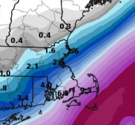
-
I'd be thrilled to get 5 inches from this. I'm glad the bad trends of the last couple days stopped and we're headed back in the right direction tonight. A light to moderate event looks likely.
-
Feb 22nd/23rd "There's no way..." Storm Thread
balltermen replied to Maestrobjwa's topic in Mid Atlantic
10:1. SV doesn't kuchie or update their windows 96 like graphics -
Threw precip a bit further north. Blizzard for cape and islands. AIFS looks good too
-
Feb 22nd/23rd "There's no way..." Storm Thread
balltermen replied to Maestrobjwa's topic in Mid Atlantic
Is IVT the new meso "atmospheric river". cool. i like it -

“Cory’s in NYC! Let’s HECS!” Feb. 22-24 Disco
weathafella replied to TheSnowman's topic in New England
Another win for the machines or a comeuppance? -
Is the IVT even reliable meh
-
Euro is a tick east but still nice
.thumb.png.dbce97999064ef43c229606e4daffc9d.png)
-

Feb 22nd/23rd "There's no way..." Storm Thread
HighStakes replied to Maestrobjwa's topic in Mid Atlantic
Of course! -
If I wanted to get edged I could handle that myself
-
At least we have 2 ways to score a little fresh pow
-

Feb 22nd/23rd "There's no way..." Storm Thread
ravensrule replied to Maestrobjwa's topic in Mid Atlantic
Do you have a mirror handy?. -
Feb 22nd/23rd "There's no way..." Storm Thread
HighStakes replied to Maestrobjwa's topic in Mid Atlantic
This Euro run hints at how someone that gets lucky with the IVT can pick up a foot. Where that ends up being becomes a nowcast. -

Feb 22nd/23rd "There's no way..." Storm Thread
DDweatherman replied to Maestrobjwa's topic in Mid Atlantic
I’ve seen many of those ways on both sides, I can concur. -
Low, long rumbles.
-
Tomorrow night we should know if we still have high-end potential or if we're going to get "edged" again.


.png.868cf9cf1912153f6f5b66d831e1fc3d.png)


