All Activity
- Past hour
-

July 2025 Obs/Disco ... possible historic month for heat
dryslot replied to Typhoon Tip's topic in New England
I hope we 7-10 here. -

July 2025 Discussion-OBS - seasonable summer variability
LibertyBell replied to wdrag's topic in New York City Metro
ideal weather!! -
July 2025 Discussion-OBS - seasonable summer variability
LibertyBell replied to wdrag's topic in New York City Metro
deep blue skies are ideal, we had that for the Fourth a few years ago, was that in 2018? I don't remember the year.... -

July 2025 Obs/Disco ... possible historic month for heat
Chrisrotary12 replied to Typhoon Tip's topic in New England
Wind is ripping. -
July 2025 Discussion-OBS - seasonable summer variability
LibertyBell replied to wdrag's topic in New York City Metro
Don what are the geographical differences that are causing these different results? I would expect more rainfall in the West because they have an ocean to the west of them (the jet stream goes west to east for the most part) and less rainfall in the East because we have an entire continent to the west of us. Another thing worth noting about the 60s is that although they were dryer, they had a lot more snow than the decades surrounding them-- my ideal combo, lots of snow in the winter and dry and hot weather in the summer. 1960-61, 1963-64 and 1966-67 were all classic and even historic winters. -

July 2025 Obs/Disco ... possible historic month for heat
SJonesWX replied to Typhoon Tip's topic in New England
can confirm it was pretty windy for a few mins, but now it's just some rain -

July 2025 Obs/Disco ... possible historic month for heat
Typhoon Tip replied to Typhoon Tip's topic in New England
anyway, you'll go back sunny in a half hour ... we'll see if we can recharge. -
July 2025 Obs/Disco ... possible historic month for heat
Typhoon Tip replied to Typhoon Tip's topic in New England
we had a wind shift prior to this line moving in ... was SW ..now WNW I think this was a processed air from when this was over eastern NY earlier this morning. it's not really associated/generated by this current/nascent stuff because it was too far out ahead. -

July 2025 Obs/Disco ... possible historic month for heat
JJBASHB replied to Typhoon Tip's topic in New England
Watching a plane take off right now. That cell was weird, it formed a bit ahead of the line and was stationary over the city for a few frames. No rain but sustained 33 with a gust to 47. Car was rocking a bit. -

2025-2026 ENSO
40/70 Benchmark replied to 40/70 Benchmark's topic in Weather Forecasting and Discussion
Yea, that cooling of the subsurface towards the dateline was expected with the weakening of the WWBs....will probably progress eastward amd at least somewhat upwards. -
Couldn’t ask for a better holiday weekend weather wise
-

July 2025 Obs/Disco ... possible historic month for heat
weatherwiz replied to Typhoon Tip's topic in New England
The dew trends have been interesting. It still seems though that the HRRR is a bit off with the dews but it does increases dews later this afternoon/early evening (as you'd expect) and that's when it kind of generates more precip. Also wondering if maybe we dry things out a bit too much in the mlvls. It's going to be interesting to see how things unfold later this afternoon. -

2025-2026 ENSO
Stormchaserchuck1 replied to 40/70 Benchmark's topic in Weather Forecasting and Discussion
Actually some big changes in the ENSO subsurface over the last 2 months. -

July 2025 Obs/Disco ... possible historic month for heat
metagraphica replied to Typhoon Tip's topic in New England
85/61 here. Definitely feels dryer down in SE CT than yesterday. Still moist along the shore however. 79/70 at KGON. -

July 2025 Discussion-OBS - seasonable summer variability
SACRUS replied to wdrag's topic in New York City Metro
12PM round up: EWR: 90 ACY: 89 PHL: 89 ISP: 88 LGA: 88 TEB: 88 New Brnswck: 88 JFK: 87 BLM: 87 NYC: 86 TTN: 85 -

July 2025 Obs/Disco ... possible historic month for heat
dendrite replied to Typhoon Tip's topic in New England
63.6° -RA -
July 2025 Obs/Disco ... possible historic month for heat
weatherwiz replied to Typhoon Tip's topic in New England
We may actually get screwed down here. Dews are dropping behind that feature moving through...unless they rebound -
July 2025 Obs/Disco ... possible historic month for heat
Chrisrotary12 replied to Typhoon Tip's topic in New England
Nice cell just popped over MHT. -

July 2025 Obs/Disco ... possible historic month for heat
bobbutts replied to Typhoon Tip's topic in New England
Heavy rain but not much lightning or wind in Bow. -
2025-2026 ENSO
40/70 Benchmark replied to 40/70 Benchmark's topic in Weather Forecasting and Discussion
Personally, I'll take warmer if it means wetter, which it should. Last season was the worst of the past several for me. -
July 2025 Obs/Disco ... possible historic month for heat
dendrite replied to Typhoon Tip's topic in New England
Afternoon before the 4th…was probably at a standstill anyway. -
2025-2026 ENSO
40/70 Benchmark replied to 40/70 Benchmark's topic in Weather Forecasting and Discussion
This is one example of why GW doesn't always mean a slew of cat 5 hurricanes.....the low thermal gradient between the subtropical and tropical ocean is fostering this stifling stability, which is why the tropics are quiet. -

July 2025 Obs/Disco ... possible historic month for heat
HoarfrostHubb replied to Typhoon Tip's topic in New England
Pouring here. -
Imagine if we could actually see the actual real raw US average temperature trend?
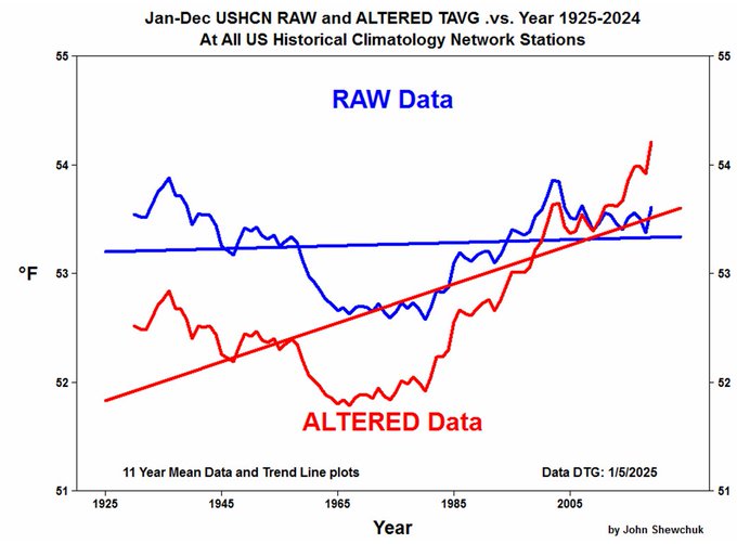
-

July 2025 Obs/Disco ... possible historic month for heat
bch2014 replied to Typhoon Tip's topic in New England
Storming in Meredith, but nothing too out of the ordinary.


