All Activity
- Past hour
-
At least we’re not burning prime climo but I am very concerned given it being Nina and pacific heading to crap. All this blocking and +PNA we’ve had has still managed to produce a “heatwave” and northern storm track so losing blocking and pacific turning bad does not bode well
-

November 2025 general discussions and probable topic derailings ...
alex replied to Typhoon Tip's topic in New England
And got some nice icicles overnight lol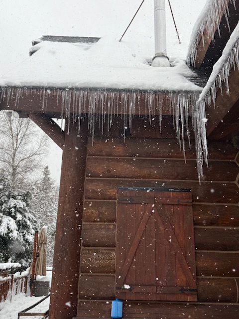
-
November 2025 general discussions and probable topic derailings ...
alex replied to Typhoon Tip's topic in New England
Snowing nicely again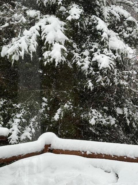
-

November 2025 general discussions and probable topic derailings ...
dendrite replied to Typhoon Tip's topic in New England
Hopefully it all comes in 1 storm. -
November 2025 general discussions and probable topic derailings ...
dendrite replied to Typhoon Tip's topic in New England
They’re running for their lives up here. Lots of good ol’ boys up the hill shooting off their heavy artillery. I don’t even dare walk into the woods out back right now. There’s been a lot of wild turkeys around lately and I often see them stopping cars when they cross. -

November 2025 general discussions and probable topic derailings ...
Torch Tiger replied to Typhoon Tip's topic in New England
Hopefully a latitude winter. 100" there 30" here -
The snow came down furiously in the late afternoon/evening. I have some videos from then and I recently rewatched them and remembered how heavy it was coming down.
-
Most of us had a weaker 500 mb PNA this December than last year using different methods.
-
Completely agree. I see the December, 1983 talk by some as being equally ridiculous….volcanic stratosphere from a VEI-5 tropical eruption the year before, +QBO, +PDO
-
November 2025 general discussions and probable topic derailings ...
dendrite replied to Typhoon Tip's topic in New England
Fruit fly in the coffee this morning? -
Raked the yard yesterday. Guessing you won’t be able to tell by this evening.
-
 My wife almost hit one last week, a small deer ran into the road in front of our car and just stopped and stared into the headlights. Close call but the little guy was alright.
 -

2025-2026 ENSO
donsutherland1 replied to 40/70 Benchmark's topic in Weather Forecasting and Discussion
Yes. A PNA- is one of my baseline assumptions for December. The combination of EPO-/WPO-/AO- with a PNA- isn't all that bad based on the composite values and the majority of dates in the clusters for such a setup. There should be some intrusions of cold air into the East with perhaps some snowfall prospects. I could see December finishing with 2"-4" monthly snowfall in the NYC area (much more in the Great Lakes Region, especially Detroit to Toronto). For now, I don't think a blockbuster snowy month is in order. I don't think we'll see anything close to December 2010-type cold. I do believe that the EPO-/WPO- should thwart the possibility of a top 10 warmest December. Given the timeframe involved, changes are still possible. -

November 2025 general discussions and probable topic derailings ...
CoastalWx replied to Typhoon Tip's topic in New England
Wonder if anybody knows that scene. -
November 2025 general discussions and probable topic derailings ...
CoastalWx replied to Typhoon Tip's topic in New England
-
November 2025 general discussions and probable topic derailings ...
CoastalWx replied to Typhoon Tip's topic in New England
“Mountain Magic” -
November 2025 general discussions and probable topic derailings ...
Torch Tiger replied to Typhoon Tip's topic in New England
Who's we -
The ensembles are starting to show more of an Aleutian/Bering Sea ridge setting up in early December as opposed to an Alaskan ridge. If correct, that’s going to allow a lot more -PNA/RNA. I know Ray expected this to happen for December….
-
But it FEELS like it’s the windiest and that’s what really matters
-
November 2025 general discussions and probable topic derailings ...
dendrite replied to Typhoon Tip's topic in New England

-

Central PA Fall Discussions and Obs
mahantango#1 replied to ChescoWx's topic in Upstate New York/Pennsylvania
Wxrisk.com MILD / DRY TRAVEL DAY WED 11/26 and TURKEY DAY 11/27 FOR EASTERN US then the stuffing goes sideways IMAGE #1 is the 500mb map from the European Ensemble valid as of November 25 on the left and November 30th on the right. and you can see the massive changes that occurs during the Thanksgiving holiday across the Central and Eastern us and North America in general. IMAGE #2 shows the 850mb temperatures (approx 1 miles above ground) … this is essentially the basic guide for used in determining snow versus rain during the winter months. and you can see how this is really cold air which is delineated by the -10C at 8:50mb with a yellow line it plunges dramatically Southward during Thanksgiving weekend. -
Central PA Fall Discussions and Obs
mahantango#1 replied to ChescoWx's topic in Upstate New York/Pennsylvania
Wow, and we have the winter and spring winds to go till it starts settling down. -

Central PA Fall Discussions and Obs
Mount Joy Snowman replied to ChescoWx's topic in Upstate New York/Pennsylvania
Low of 50. Winds were howling overnight. Should be some nice squalls around today. I got a final mow and a bunch of yard cleanup in yesterday. Ready for winter, despite some mild spells looking to take hold over the next few weeks. -
November 2025 general discussions and probable topic derailings ...
CoastalWx replied to Typhoon Tip's topic in New England
I mean we have pics of Alex’s snow covered evergreens, PFs chairlifts shrouded in dendrites, and Jspin’s novels of how the snow texture changed from 2k to 3k at Smugglers Notch. What more could you ask for? -

Central PA Fall Discussions and Obs
Blizzard of 93 replied to ChescoWx's topic in Upstate New York/Pennsylvania
@sauss06 maybe would lend a hand as well? I am already done with wind this Fall.


