All Activity
- Past hour
-
Just upped to a warning here, I can hear thunder.
-
There's no way this is your first heat wave there. None. I've had like 10 of them here.
-
Yeah the dews stand out. No real change. If it was mixing out, and 10-15F temp changes in short order, you'd think you'd see at least 5-7 degree dew changes? I just think when we saw PBG up here do a 15 degree increase to 100F, the dew plummeted with the temp change.
-
Nothing from the Winthrop CWOP. https://www.weather.gov/wrh/timeseries?site=D3706&hours=24
-
Beer?
-
It's a little too early in the day for rain. It's a nice respite, but once this passes and the sun comes back out it's gonna be a hellish sauna out here.
-
I don’t have any physical records but I don’t recall 3 straight days of 90+ here since 2005. Did ORH do it then?
-
 So far-high of 96 at FRG, 97 for ISP.
 -
I would also expect to see a baro change and dewpoint change with such temp fluctuations and I don't see any.
-

E PA/NJ/DE Summer 2025 Obs/Discussion
JTA66 replied to Hurricane Agnes's topic in Philadelphia Region
I think Storm Ranger10 is in for an oil change. 96F/DP 75F...getting an occasional cloud passing by. -
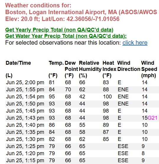
Jun 25, 1:55 pm 84 70 62 88 ENE 14 10.00 SCT060 29.96 29.98 Jun 25, 1:54 pm 95 68 42 100 ENE 14 10.00 FEW037 BKN065 1015.10 29.96 29.98 95 78 Jun 25, 1:50 pm 93 68 44 98 ENE 14 10.00 SCT050 BKN070 29.96 29.98 Jun 25, 1:45 pm 93 68 44 98 E 14 10.00 SCT050 BKN070 29.96 29.98 Jun 25, 1:43 pm 93 68 44 98 E 15G21 10.00 SCT050 BKN070 29.96 29.98 Jun 25, 1:40 pm 86 68 55 89 E 10 10.00 BKN050 BKN070 29.96 29.98 Jun 25, 1:35 pm 84 68 58 87 E 10 10.00 BKN050 BKN070 29.95 29.97 Jun 25, 1:30 pm 82 68 62 85 E 10 10.00 BKN050 BKN070 29.96 29.98 Jun 25, 1:25 pm 79 66 65 ESE 9 10.00 BKN050 BKN070 29.96 29.98
-
Yeah something is wrong. To pull down a 5min mean from 95F to 84F in 1 minute requires a big number coming off and a low one going on.
-
yeah ha just typed a similar explanation
-
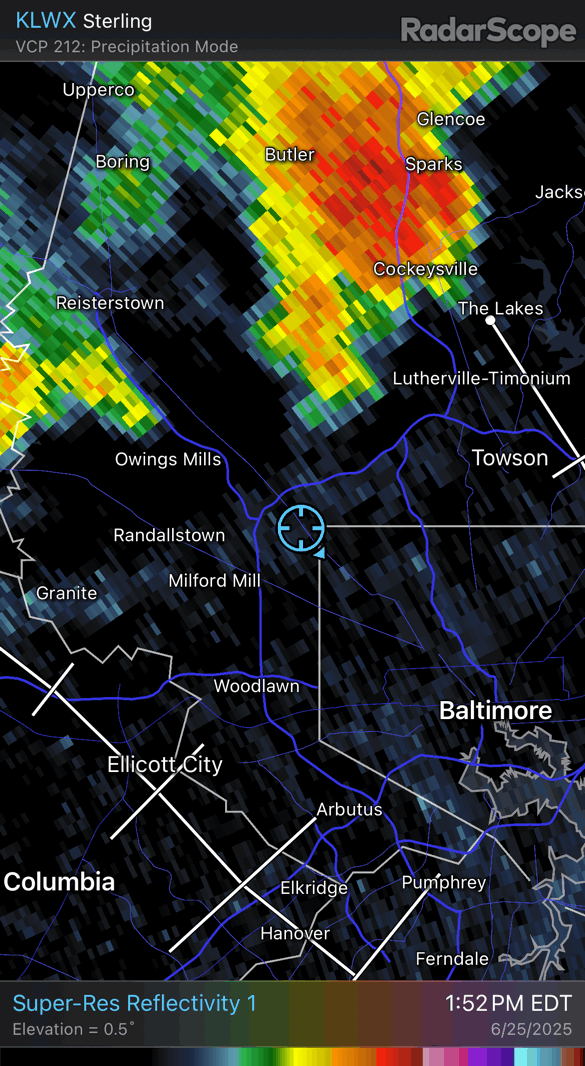
The severe storm missed me at the house but knocked power out at the office which kicked me off the network and my mapping haha
-
I bet that's low level folding There's NW wind moving into Boston and it's "tipping" the air mass over the really shallow E component and it may be mixing irregularly back down
-
 98 is the high here so far
 -
Must be some swirlies in there. Back to 81F
-
Damn! I got Stephens City’d!!!

-
I don't know, but something is off. I can't explain it as a rogue heat plume off the runway.
-
1 minute. 1:54pm... 95F 1:55pm... 84F
-
100/67 at KGED (Georgetown DE) at 1:35 PM 98/73 at 1:55 PM in KDOV. Almost there
-
 Looks like the high was 102 again at JFK.
 -
Back down to 81F. That's a swing. What happened from 1:40pm to 1:43pm? And then 1:54pm to 1:55pm.
-
 94/74 for me in Lindenhurst, heat index at 105 again.
 -
Made it to 92 so far today. With clouds & scattered thundershowers, that’s probably as high as it will get today.