All Activity
- Past hour
-

E PA/NJ/DE Summer 2025 Obs/Discussion
JTA66 replied to Hurricane Agnes's topic in Philadelphia Region
Thought I could sneak in a Jebwalk this morning. One the the crappiest Jebwalks of all time! 88F/DP 77F at 10am -
DCA hit the benchmark of 90 at the 10am ob.
-
Seven days:
-
Played a little Ryder Cup style tourny down in PA this weekend (Sunday singles rained out by the MCS). Had my first birdie since 2023 in the practice round Friday, but the real fun was going down 3 through 7 in our best ball match - only to come roaring back winning 7 of the next 8 holes to close out the match on 15. I'm currently a 21.5 index, but I had a middle 9 hole stretch of +3. That will do a lot of damage when you are getting strokes.
-
Use Walt's thread for the heatwave discussion....
-
Tony no extreme heat on the horizon (95+ for all areas) after this week?
-
 from rain to heat lol
 -
The blackout began on July 13, 1977. The high that day was 93°.
-
The 12z 3k NAM coming out right now is doing well with temps at 10AM, showing low to mid 90s in the NYC area. It kind of caps temps there though until they start to drop from a seabreeze in the afternoon.
-
over 90 here by 9 am !
-
This still can't compare to the 2007 heatwave when I was in Southern Pines where it got to 108F with a heat index of 121F.
-
1.76" on July 18, 2012. The rain was associated with a cold front that crossed the region after the high had been reached.
-
I love the heat, but this is crazy... 92 degrees before 10am. Actual is 91.8 with a DP of 79.2 for a heat index of 109.2 as I type this.
-
 Hard to believe Philly hasn't hit 100 in almost 13 years
 -
Yes as long as the sun is out, I don't have those allergies.
-
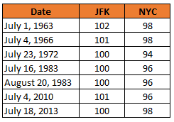
Intriguing stats Don! How many days have there been when JFK reached 100 and NYC did not? One I remember right away is July 4, 2010.
-
Very weak gradient in the region may spare shores by allowing the sea breeze to claim .. even some distance inland. Noticing Logan kicked around to an ESE and no heat out there... It's feeble. Doubt flags are even wobbling much west of Back Bay, but as we warm the interior that may press inland. NAM nailed that idea for BOS in the FOUS grid actually. I was wanting to geek out and test that and here we are. Wonder if we even see a bit of a breeze boundary on some rad products in the afternoon doing that thing where it's side-winding slowly inland. Anyone west of I-95 has no hope for relief. It's now 86 to 88 at most garden sites ( in between the NWS obs) and some of the NWSers like the Oxbow site on Rt 2 are already 90 - sorry read that wrong, 86, but that is typically a hotdog. Anyway, there's so little gradient we're not getting any natural ventilation.
-
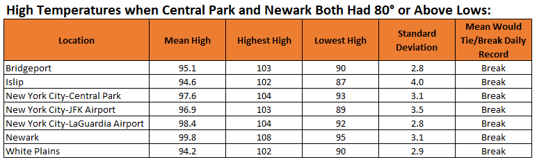
Today is the first June day on record where both Newark and New York City (Central Park) had low temperatures of 80° or above. The last such occurrence was July 28, 2020. Overall, it is the 32nd such case during the common period for their records. Below is a chart showing the mean high temperature, highest maximum temperature, and lowest maximum temperature for such cases.
-
Give me 90 at 9 for the urban centers and 10 after 10 for the interior rad spots. I feel like there’s still some low level recovery in the valleys at that time especially if lows are 65-70°.
-
Smoothed out but rain chances Wed evening, Thu evening and each of Fri - Sun could get some localized spots >2 inches plus where storms fire. The weekend looks mainly ok hot/humid but scattered storms so far.
-
Dew point holding steady at 74-75 here. Fungus/mildew/mold spores must be high still. Hope the sun can temper those.
-
it especially doesn't make sense since in this kind of heat the moisture from the rain evaporated the same day that it fell.
-
Again the issue more with central park is its used for the center / mecca of NYC weather when reporting. So for example today's the first 90 degree day in NYC when in fact there have been between 2 - 4 already. First 100 degree day in 13 years when there have been more recently in NYC/NJ metro proper. Perception.
-
88/74 approaching 10 am Sultry.
-

E PA/NJ/DE Summer 2025 Obs/Discussion
Hurricane Agnes replied to Hurricane Agnes's topic in Philadelphia Region
And I hit 91 @9:39 am (my current temp) with dp 79 with hazy skies.