All Activity
- Past hour
-
isn't that the truth. Of course nothing will ever come close to the pain of that dry slot.
-
Daughter just had her 2nd surgery in a little over a month. 1st was a cholecystectomy. Ended up showing it was partially nectoetized. Scary. 2nd surgery was scheduled. Spinal surgery for tethered cord. This should alleviate many if here strength and pain issues. Sad it took us close to 8yrs to get this diagnosed. 1st day post surgery she had to remain prone. Yesterday was 1st day to attempt to sit up. Was rough. Went dizzy, lost vision and hearing and had to lie back down. Also got a spinal induced migraine. See what today brings. Optimistic she’ll be able to come home tomorrow or Monday depending on how physical therapy session show her progressing back to some level of basic activities.
-
Lots of coastals being modeled.
-
Not too bad of a start though. Breaks of sun before overcast rolled in. Line looks broken so maybe we salvage a not so bad a day.
-
Ya' a little over .20" definitely was a surprise.
-
A freeze here this morning with 31.
-
I am all good. I am sorry for being MIA this season. Work has gotten in the way and plus with a slow season, I tend not to be as active also.
-

2026-2027 Strong El Nino
bluewave replied to Stormchaserchuck1's topic in Weather Forecasting and Discussion
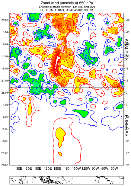
My guess is that the ultimate peak we see in the fall will probably be influenced by how much WWB follow up we get. The recent models back off a bit for early May. They now forecast the next larger one by mid to late May. Could make the difference between a peak in the 2.0 to 2.4 range vs 2.5+. New run Old run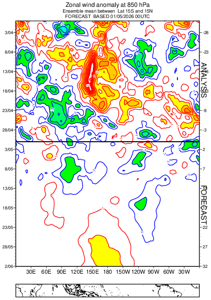
-
Interesting to note the cool temps have backed off somewhat for the month and the coolest anomalies shifted west to the Lakes and Midwest. East of Apps not really that cool anymore we get closer . A sign for the summer most likely
-
Another Steiner for most . .03 that barely wet the pavement. Looks like some clearing moving in soon from W CT
-
41F. Lt. Rn. This blows Sent from my SM-S921U using Tapatalk
- Today
-

2026-2027 Strong El Nino
snowman19 replied to Stormchaserchuck1's topic in Weather Forecasting and Discussion
Once this record DWKW surfaces on the coast of South America, the eastern regions (1+2 and 3) are going to take off for the races. And there is nothing to attenuate it. I think it becomes very east-based over the next month. As per research, the extreme +PMM strongly supports an East Pacific/east-based El Niño. I think we part ways with 2015 in that respect soon. -
May '77
-
Pass the canoe is more like it
-
Alex's bagles is crazy busy. I'm sure they're in no hurry for HHH
-
The one day I want stein. Hopefully just a passing shower this aftn.
-
Pouring here in northern Longmeadow/far southern Forest Park I'm going to enjoy the cool weather bc the inevitable miserly heat and humidity might be slightly delayed but not denied
-
Good tune
-
2026-2027 Strong El Nino
bluewave replied to Stormchaserchuck1's topic in Weather Forecasting and Discussion
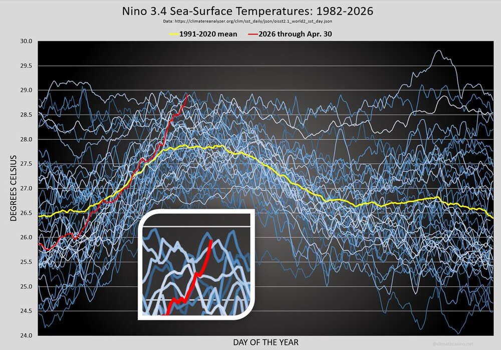
The all-time Nino 3.4 C record was 29.8C set in November 2015. It will be interesting to see the new Euro forecast in a few days. As the middle of its ensemble mean forecast was fairly close with the 2015-2016 event. https://www.cpc.ncep.noaa.gov/data/indices/ 18NOV2015 23.8 2.0 28.0 2.9 29.8 3.0 30.3 1.7 https://www.ecmwf.int/en/newsletter/151/meteorology/2015-2016-el-nino-and-beyond The 2015/16 El Niño broke warming records in the central Pacific, represented by the NINO3.4 and NINO4 indices. At its peak in November 2015, the NINO3.4 SST anomaly reached 3.0°C, breaking the previous record of 2.8°C set in January 1983. In the NINO4 region, large positive anomalies are hard to achieve because average conditions are already warm. In 2015, the anomaly reached 1.7°C, a substantial increase of 0.4°C on the previous record, set in 2009. SST analyses become less precise going back in time, but the size of the anomalies in NINO4 and NINO3.4 means we are fairly confident that these are record values for the whole of the observational period back to 1860. By contrast, in the eastern Pacific (monitored by indices for the NINO3 and NINO1+2 regions) the El Niño remained below the level of the 1982/83 and 1997/98 events. It must be borne in mind that the anomaly records depend on the reference climate, which in this case is a 30-year climate (1981–2010).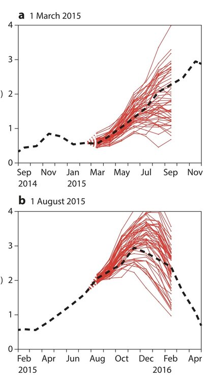
-
Sucks the weekend is well below normal.
-
Looks like more rain than expected. Especially out by hippie.
-
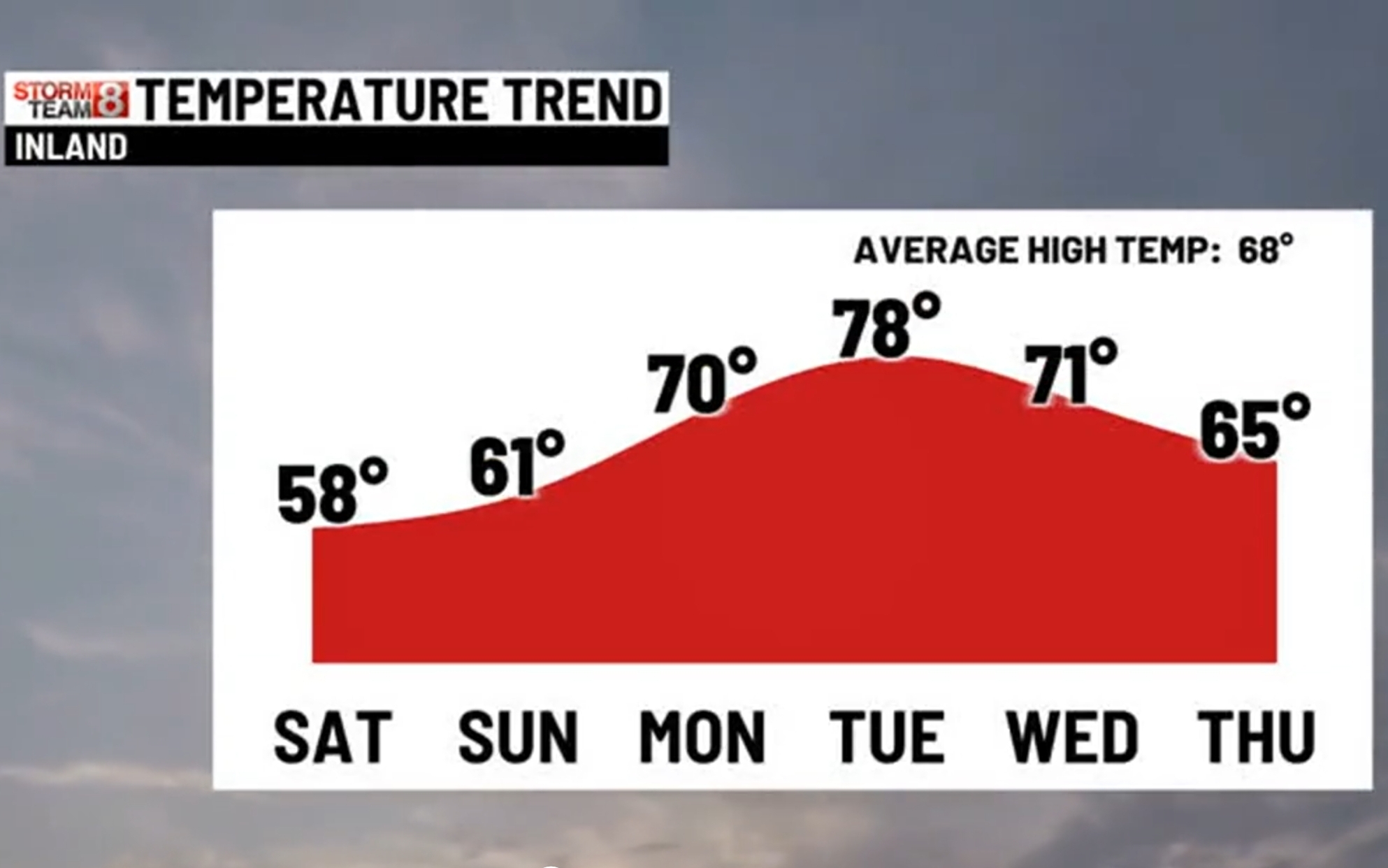
Nice stretch of a few days of above normal coming up.

-
2026-2027 Strong El Nino
snowman19 replied to Stormchaserchuck1's topic in Weather Forecasting and Discussion
-
that was you, when i did that map on March 2nd. On the March 3-4th storm you tagged me with 0.5" so that should put you at 73.2"
-
2026-2027 Strong El Nino
bluewave replied to Stormchaserchuck1's topic in Weather Forecasting and Discussion
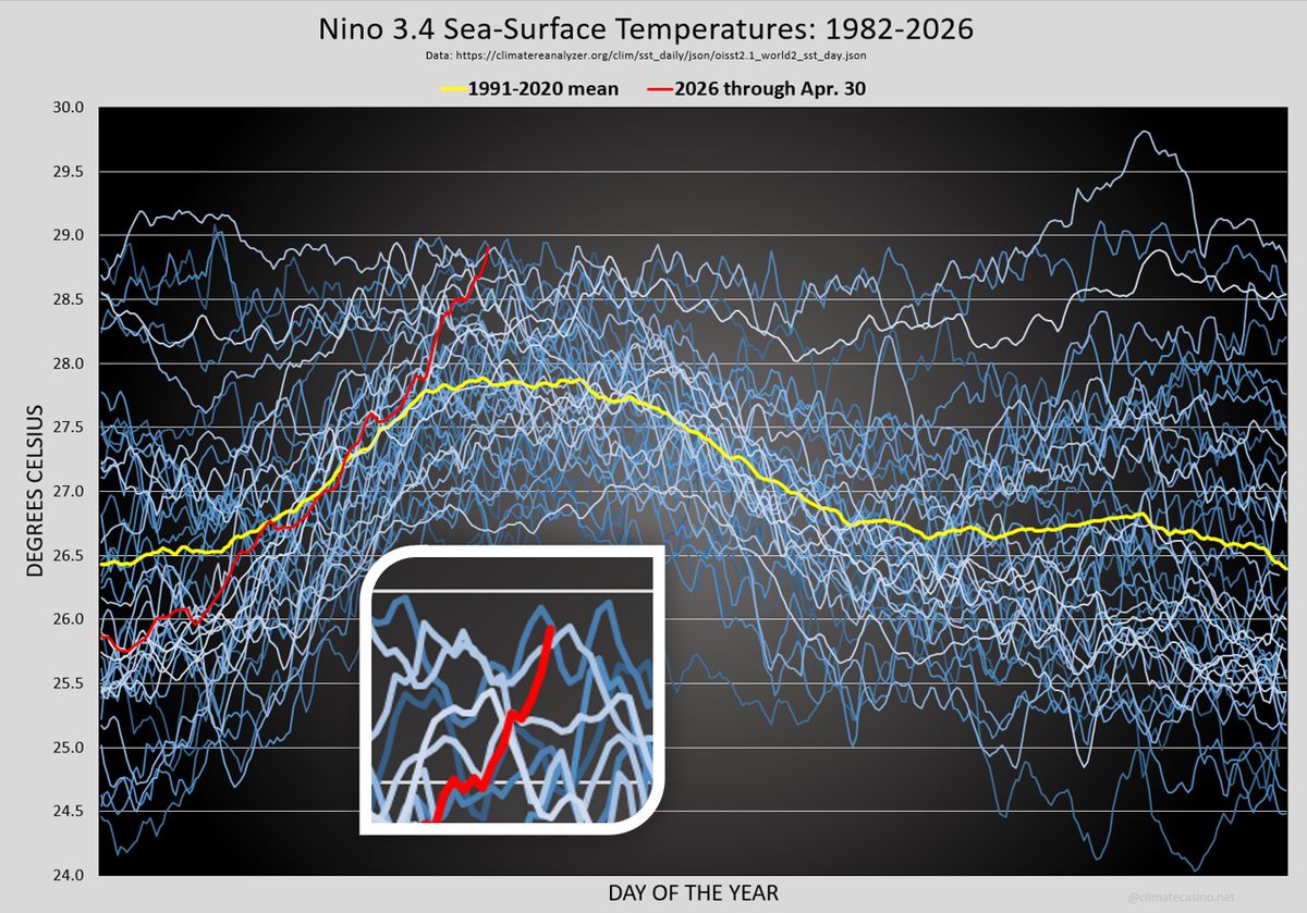
Pretty impressive for Nino 3.4 SSTs to be approaching 29C in early May. This is near the record for so early in the El Niño development. The 30C warm pool is fairly expansive near the Dateline.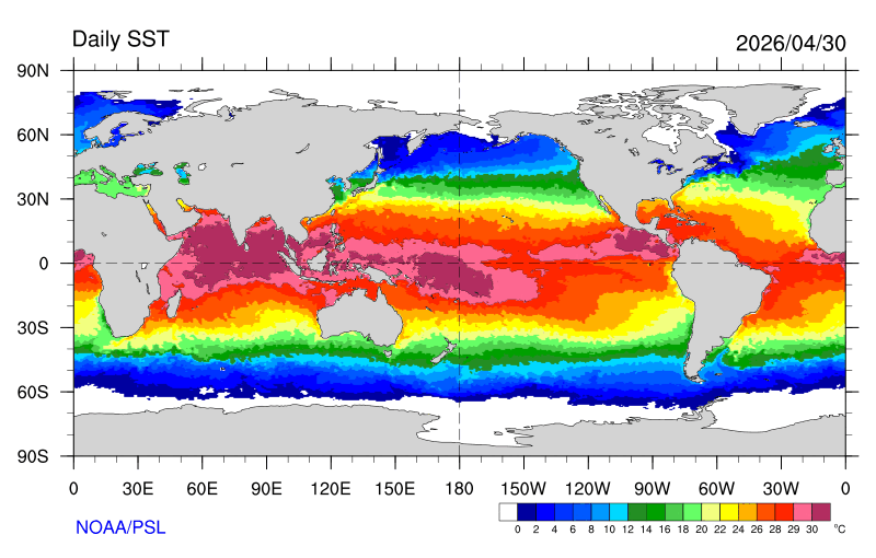


.thumb.jpg.049f4a7f726ada07e8cd30bd17e713cb.jpg)