All Activity
- Past hour
-
Best fuel for molotov cocktails is diesel. Spreads flames and doesn’t explode in your face as soon as you light it. if you only have gasoline, and alternative method is to get some styrofoam and mix it with the gas until you get kind of slurry/gelatin. This is essentially napalm - well lets just call it for what it is: its actual Napalm. Don’t get it on you. It is sticky af. You cannot put it out either until its done burning. I think there is enough O in the styrofoam to keep it going even submerged. Very nasty but effective. It also will not explode as easily if mixed properly, so safer than molotov with gas (if safety is a priority). I would reserve these remedies for only the most stubborn wasps. Basic brake cleaner is super effective without even lighting it! Go with that first.
-
Same to you Rob! .
-
Incredible weather alert
-
Beautiful day, but we need rain again. Drove over the Potomac and Shenandoah today near Harper's Ferry and there are lots of rocks exposed again... trees in my neighborhood are also showing signs of stress.
-

TROPICAL WAVE LOCATED IN CHAD, AFRICA (NOT 96L)
GaWx replied to BarryStantonGBP's topic in Tropical Headquarters
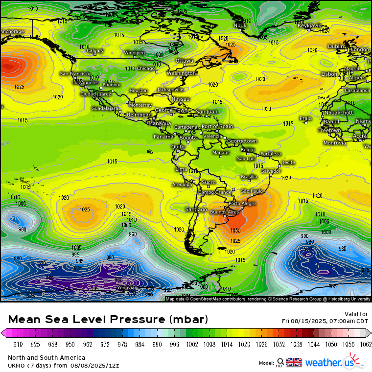
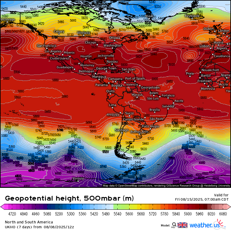
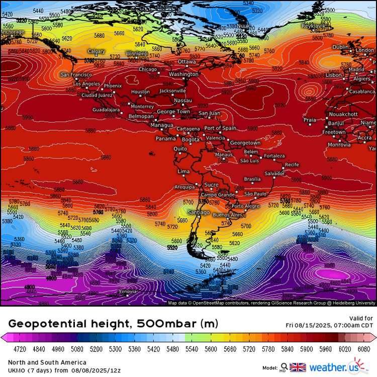
12Z UKMET maps are in at 168 hours. The question on that run for Conus had it gone out further is would the TD have recurved between those two H5 ridges and allow a safe recurve or would that weakness have filled in to block it and result in a U.S. threat? We’ll never know but fun to speculate: 12 UKMET at 168 sfc: moving WNW at 18 mph 430 miles ENE of PR: 12Z UKMET at 168 at H5: weakness between ridges just to NW could have later easily recurved it safely well OTS had it not filled in but we’ll never know: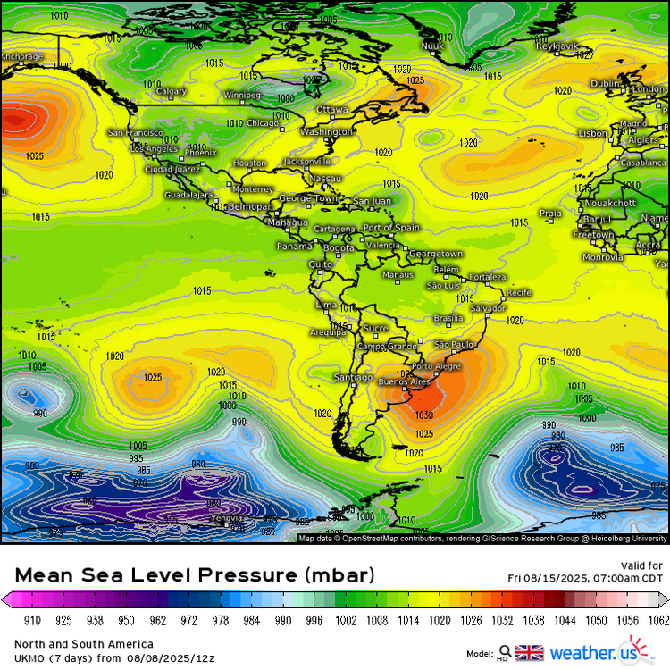
-
TROPICAL WAVE LOCATED IN CHAD, AFRICA (NOT 96L)
GaWx replied to BarryStantonGBP's topic in Tropical Headquarters
Pretty wide spread still. Aug 18-22 most likely IF it threatens imo. -
We think this is that
-
Earliest heat wave is Feb 2020.
-
feels like we are gonna pay for this at some point
-

TROPICAL WAVE LOCATED IN CHAD, AFRICA (NOT 96L)
TampaMan replied to BarryStantonGBP's topic in Tropical Headquarters
I appreciate you doing that for me. That makes me nervous, knowing there may be absolutely nothing to stop it from gaining strength and on top of that, shooting directly at Florida or into the Gulf. -
TROPICAL WAVE LOCATED IN CHAD, AFRICA (NOT 96L)
TampaMan replied to BarryStantonGBP's topic in Tropical Headquarters
Basically, this one could very well be a threat to either the Gulf States, Florida or the East Coast and there's no telling until about 5 days or so from now. IF it did happen, what would your best guess be on the date that it would arrive to Contus? -
Models did the same thing in 1954
-
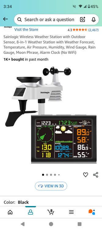
Got me a new complete weather station coming tomorrow.. looks to be a lot more accurate that my last one ... opinions?
-

TROPICAL WAVE LOCATED IN CHAD, AFRICA (NOT 96L)
Newman replied to BarryStantonGBP's topic in Tropical Headquarters
The EPS and GEFS both came out hot with current 96L as well and slowly backed off to the point now we're seeing significantly less individual ensembles even produce a weak tropical disturbance, if anything at all. The EPS was consistent with the quick recurve north and looks to have notched a victory here with regards to track, but initially it was much more potent with 96L. All of that to say... Until there's an actual tropical system, these models usually run hot on development. I think this next wave will take longer to develop than currently modeled. I believe the pattern favors the next wave making it into the SW Atlantic, and the environment is much more conducive to development. Give it 4-5 days here and the ensembles will be telling -
Just noise, otherwise seems locked in.
-
The PDO is not good. Extremes in, though, weather can wreck havoc. I remember some of those extremely -NAOs turned out to be terrible here. The NAO cycle right now appears to be trending towards more negative episode. I am gonna guess it fires early and holds off/on through January(beginning in late November). We are always fighting something. If it isn't the PDO, it is something else. However, during the last few winters we have found extreme cold making its way into the area despite a multitude of bad teleconnections. Until I see otherwise, I am riding the seasonal trend of cold early to mid winter. One of these days that extreme cold is gonna hit the atmospheric river over the TN Valley. I am gonna be here for that action Lord willing!!!!
-

TROPICAL WAVE LOCATED IN CHAD, AFRICA (NOT 96L)
csnavywx replied to BarryStantonGBP's topic in Tropical Headquarters
The blues over the N/E US and reds over Canada are showing a jet stream that's pushed north well into Canada -- which will make it more difficult for any storms that develop to recurve out to sea. Other than some cool-ish sea surface temps in the eastern basin and maybe some occasional drier air, there's no real obvious feature here that could hinder development. My guess is that it might take longer to develop than some of the models currently have, but it's a real threat if it makes it into the western basin with that upper level pattern in place. -
You need some new friends

-
What I notice most is how backed up the mid-latitude jet is, as there are 3 regions with lower 500mb heights than the warmth to the north. When I mapped DC and Baltimore's top snowfalls/snowfall months/snowfall seasons, the same thing is true.. there are 3 areas of lower heights than even the -AO/-NAO +500mb heights to the north. This tells me that general -H5 is more important than having Polar blocking. I think the problem with my analogs is that the northern ridge is too far north: over 90N. 90N puts a mean trough at 45N, but not as much 39N. We need classic Greenland/Davis Strait blocking to do better. Unfortunately with Arctic ice melt, it's something that reverses 100% the following Winter, and that's centered 90N. I think this is why the new Euro seasonal has ridging/blocking centered at 90N.
-
Like I said, that's immaterial. This is a statewide average. This month was hotter even with the raw and unadjusted data. The mean of 105 stations was 78.94F, versus a mean of 78.83F in 1934. And that was with a lot fewer stations (50) which were more biased towards warmer, low-elevation and city sites. The 1934 data is also biased up a bit due to the observation time being 5 or 6 pm in the afternoon for cooperative observers, versus 7 am today. Even ignoring that, it was still hotter last month. 1901 was actually closer, with an unweighted mean of 78.86F, but that was the average of just 42 stations heavily biased towards the Coastal Plain. The gridded values from NCEI look very reasonable, with all of those years among the hottest and 2012, 2020 & 2025 being basically tied. But you are correct to say it "squeaked by" as it was indeed a 3-way tie, not a new outright record, and there are several other years within a degree or so. Pretty typical at a state level... it's rare to beat prior records by more than a few tenths of a degree particularly in the summer. An individual site sometimes beats an old record by 1+F but very rarely in the state averages, and never in the summer when variability is at a relative minimum.
-
With the exception of 2014. All the others were below avg snowfall for me too
-
Does that mean we revert to colder anomaly or does it mean less hot anomaly but still hot anomaly? We need the northpac to cool off obviously but until I see the blues of its hues in current pac ssts anomaly, don’t know if that map means much.
-

2025-2026 ENSO
Stormchaserchuck1 replied to 40/70 Benchmark's topic in Weather Forecasting and Discussion
^Phoenix broke their all-time August monthly high at 118F yesterday. -
TROPICAL WAVE LOCATED IN CHAD, AFRICA (NOT 96L)
TampaMan replied to BarryStantonGBP's topic in Tropical Headquarters
Any chance you could explain this like I'm 4 years old? (I'm trying to learn, forgive me). If not, totally fine! I'm probably in way over my head trying to learn tropics. -
TROPICAL WAVE LOCATED IN CHAD, AFRICA (NOT 96L)
csnavywx replied to BarryStantonGBP's topic in Tropical Headquarters
It will likely struggle somewhat initially as SSTs are very marginal at first: