All Activity
- Past hour
-
-

Nov 28-30th Post Turkey Day Wintry Potential
King James replied to Chicago Storm's topic in Lakes/Ohio Valley
Already gave my call but I think we are going to be in the sweet spot back to back storms. 11.2 inches for MBY is my final final call. Enjoy the storm! -

Nov 28-30th Post Turkey Day Wintry Potential
Chicago WX replied to Chicago Storm's topic in Lakes/Ohio Valley
Nice work. Caveat on the COOP "accuracy" for sure. Some sketchy measurements in past years. Regardless, this is definitely a November for the books around here, assuming this storm acts as expected. With that said, gonna narrow my range a bit and go 6-8" final call for here. General consensus QPF numbers in the 0.60-0.80" range, ratios pretty close to 10:1, etc etc. Going to be a fun day to work tomorrow. -

December 2025 regional war/obs/disco thread
Sey-Mour Snow replied to Torch Tiger's topic in New England
Almost looks like a blue bomb for the 84 corridor and with temps this borderline I think elevation would help. 925 and 850 hover around 0 the whole time. I expect this to verify about 50 miles north of the 0c line depicted here however. what a juicy run of the euro widespread 1.5-2.5” qpf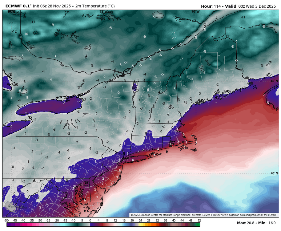
-
That run was pretty amped as far as SLP goes, Track still a bit to the east once you get up into NNE, Waiting on weather models for the EPS members.
-
Torches to the pike at 925. Let’s amp it more.
-

Central PA Fall Discussions and Obs
anotherman replied to ChescoWx's topic in Upstate New York/Pennsylvania
-
Fall line event makes sense for climo in early season
-

Central PA Fall Discussions and Obs
WmsptWx replied to ChescoWx's topic in Upstate New York/Pennsylvania
Assuming the overnight runs were bad with no activity lol -
H92 a bit warm until you get into NW CT.
-
Not the best for CT with those temps.
-
Gfs is all over the place and tossed. AI is tossed too. This will be a ORH to SNH deal on northeast. For best amounts anyways.
-

December 2025 regional war/obs/disco thread
Kitz Craver replied to Torch Tiger's topic in New England
I’d hit that -
GEFS not that inspiring.
-
Here’s the 06z OP run,
-
Lots of meh members on the gefs
-
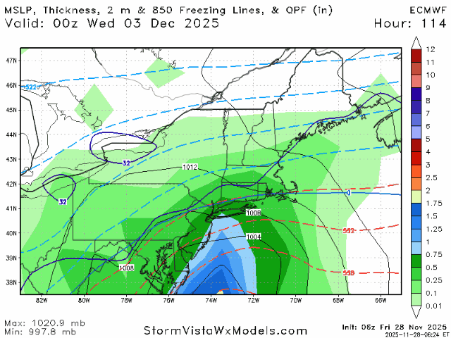
100% correct. Possible, but the 12-2 system has the deck stacked against it. No 50-50 low, no Lakes to New England H.P. as a cold air source. And of course, our long time drought pattern that no one fully understands is again an aggravating factor. The GFS dropped the QPF from 1.48" for Augusta at 06 11-27 to .60" at 06 11-28. I don't have enough fingers to count how many times this has happened during the past 4 months.
-
Looks like the last 4 seasons continue. At least days get longer in a few weeks.
-

December 2025 regional war/obs/disco thread
moneypitmike replied to Torch Tiger's topic in New England
Are you able to post any pics, Jeff or is that forbidden? -
This set-up would probably work in January with a colder antecedent air mass. Track isn't bad. Fast flow doesn't allow low to amp up and move inland.
-
Not really. Elevation won’t matter much.
-
Skynet still fairly flat…and consistent. No spiking footballs yet. We ride the ensembles.
-
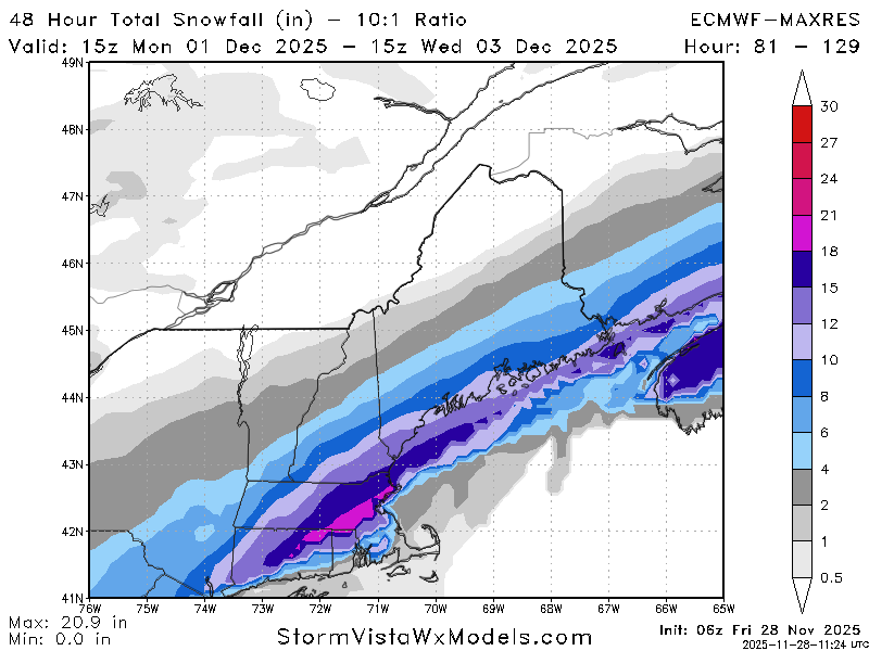
06z Euro starting to tick a bit further north, SLP down to 980mb as it makes its pass by, Decent hit in the interior of SNE/CNE.
-
6z euro still looks on for northwest crew.
-

December 2025 regional war/obs/disco thread
Damage In Tolland replied to Torch Tiger's topic in New England
Somewhat of an elevation event . At least in that depiction


