All Activity
- Past hour
-
 canadian pharmacies: canadian pharmacies online - pharmacies in canada that ship to the us
-
Too bad climo brings the temps down. Upper 50’s will still be tolerable though. Maybe low 60’s in full sun. .
-
MN HS Football playoffs start tomorrow with rain in the forecast. Should make for an interesting evening of games. THHS ended with a 6-2 record. They play a weak team to start the 1st round. Will see how far they get this year.
-

2026-2027 Fall/Winter Mountain Thread
eyewall replied to BlueRidgeFolklore's topic in Southeastern States
any suggestions on where the color is currently worth going for currently? I may still venture that way if it is worthwhile. -
October 26 2010: The lowest pressure on record for Minnesota occurs in the town of Bigfork, with a reading of 28.21 inches of mercury (955.30 mb). Very strong winds were widespread throughout the state, with peak gusts of 65 mph recorded at both Georgeville (Stearns County) and Mehurin Township (Lac Qui Parle County). 1996: A severe weather outbreak combined with a blizzard occurred across the upper Midwest. Intense low pressure tracking into Minnesota produced blizzard conditions over portions of South Dakota, while further east in Minnesota, unseasonably mild temperatures developed. Temperatures climbed to near 70, with dew points in the 50s. 1 to 1 3/4 inch hail and strong winds were reported in Lac Qui Parle, Yellow Medicine, Chippewa, and Swift Counties. These storms produced 12 tornadoes; the strongest of which received F2 ratings. Southwest of Alexandria in Douglas County, an F2 tornado with a 9 mile track destroyed several homes. One woman sustained broken bones and internal injuries when a portion of her house, with her inside, was launched 200 feet onto the interstate. This tornado also pushed over a 500 pound fuel tank. Tornadoes also touched down in Swift, Kandiyohi, Pope, Stearns, and Isanti Counties. For Monday, October 26, 2026 1859 - New York City had their earliest substantial snow of record as four inches blanketed the city. (David Ludlum) 1919 - The temperature at Bismarck, ND, plunged to ten degrees below zero, the earliest subzero reading of record for the city, and a record for the month of October. (The Weather Channel) 1926 - Barrow, AK, received a record fifteen inches of snow, and also established a 24 hour precipitation record of 1.00 inch which lasted until the 21st of July in 1987. (The Weather Channel) 1962 - A storm brought five to six inches of snow to Vermont and New Hampshire, with up to ten inches reported in the mountains. (The Weather Channel) 1983 - A heat wave was in progress over the Northern Rockies, with record highs of 81 degrees at Sheridan WY and Billings MT.(Sandra and TI Richard Sanders - 1987) 1987 - Five cities in south central Texas reported record high temperatures for the date, including Corpus Christi and Del Rio with readings of 93 degrees. Laredo TX was the hot spot in the nation with a high of 98 degrees. Thunderstorms moving over the Lower Mississsippi Valley deluged Lake Charles LA with 2.70 inches of rain in one hour resulting in severe local flooding. (The National Weather Summary) (Storm Data) 1988 - Thunderstorms moving out of northern Texas spawned five tornadoes in Louisiana during the morning hours. The thunderstorms also produced wind gusts to 75 mph at Jennings LA, and the driver of a vehicle was killed by a falling tree near Coushatta LA. Snow squalls in the Lower Great Lakes Region produced heavy snow in western New York State, with 12 inches reported at Colden. (The National Weather Summary) (Storm Data) 1989 - Unseasonably warm weather continued in the north central U.S. Afternoon highs of 78 degrees at Alpena MI, 75 degrees at Duluth MN, 79 degrees at Fargo ND, 77 degrees at International Falls MN, 76 degrees at Marquette MI, 75 degrees at Sault Ste Marie MI, and 80 degrees at Saint Cloud MN, were all the warmest of record for so late in the season. Morning lows of 63 degrees at Concordia KS and Omaha NE were the warmest of record for the date. (The National Weather Summary) Observances: 26 Mon National Pumpkin Day 26 Mon National Day of the Deployed 26 Mon Accession Day 26 Mon National Chicken Fried Steak Day 26 Mon National Financial Crime Fighter Day 26 Mon National Microneedling Day 26 Mon National Mincemeat Day 26 Mon National Mule Day 26 Mon National Tennessee Day 26 Mon National Transgender Children Day 26 Mon Worldwide Howl at the Moon Night
-
37.9 in N Smithtown. Chilly nights and the best run of daytimes of the decade.
-

2026-2027 Record-breaking El Nino
Typhoon Tip replied to Stormchaserchuck1's topic in Weather Forecasting and Discussion
So I'd be careful with the QBO in correlations. This actually happened first back in - I think ...- it was 2016, where the QBO abruptly and mysteriously halted ( in the relative sense... It even reversed for a time, mid cycle - something that had never been seen at that magnitude, if ever. It prompted me to check and sure enough, there's been publication as to the QBO as ( possibly ...) now also being affected by CC. Yes, even this is not unaffected. The study is “The disappearing quasi-biennial oscillation under sustained global warming,” by Fuhai Luo and colleagues, published in Nature Communications. Jan 29 earlier this year. It indeed describes the QBO as experiencing unusual disruptions in recent years. The idea here is that if it is doing this sort of "break down" ... that should enter the question as to how physically it is coupled with the total system - if so ... naturally and quite arithmetically the correlation goes with it. Just sayn' -
62/22 yesterday, only the 9th "forty" in 29 Octobers, and the coldest of the bunch. The others mostly had highs in the 70s. And the first clouds in 4 days this morning (but nothing falling from them). Stick season here, though the 2 nearby oaks and some understory beech have some brown hangers-on.
- Today
-
Been a balmy 75-80 every day I've been down in Tennessee visiting the baby! Down in the 40s at night though.
-

2026-2027 Record-breaking El Nino
snowman19 replied to Stormchaserchuck1's topic in Weather Forecasting and Discussion
Still a disconnect between NOAA and the Australian BOM on the official weekly RONI number…..not huge (little over 0.3) but still a difference none the less….CPC has it at +2.5C and the BOM has it at +2.8C Here’s the traditional ONI anomaly, the absolute temperature remains over 30C, which is also record-breaking: -
Been cold enough for me to have soups in the rotation 2x's a week. And the amount of grilled ham/cheese and dill pickle toasties are delightful.
-
Sports can be funny sometimes but at this point as a Minnesota fan you have the Vikings at 6-0 and in first place, the Timberwolves at 3-0 and in first place the Wild are in first place and even the Gophers football team is beating ranked teams and 5-2 overall. Setting up to be a craptacular collapseapalooza postseason. Not to mention the snowless winter and 80 degree christmas coming.
-
Same here…just hit 60° after a low of 30°.
-
2026-2027 Record-breaking El Nino
snowman19 replied to Stormchaserchuck1's topic in Weather Forecasting and Discussion
Right now I see no reason to doubt a warmer than normal December in the northeast/midatlantic based on the extremely strong correlation with El Niño/+QBO over the last 46+ years -
2026-2027 Record-breaking El Nino
Typhoon Tip replied to Stormchaserchuck1's topic in Weather Forecasting and Discussion
I don't disagree with your reasoning here and product issuance and so forth.. I would only add that the base-climate is very steep since 1997. That does sort of tilt matters from being straight up clearly attributable to ENSO. ...in terms of temperature departures down the SE ... Seasonality should also be considered - The SE could easily have fared warmer than 1997 in the absence of these warm ENSO autumns. I also have some reservation about attributes with ENSO prior to the gradient of the hemisphere drawing the El Nino into the fight. Having said that, if there's some primitive influence that's even subtle, yeah I mean there could be some synergy there that would not likely be very readily noticeable. -
The Vikings are doing their part to make sure their fans get the most gut wrenching utterly emotionally devastating eviscerating experience possible by being as good as they can now to inspire hope only to have it crushed later in some kind of epic dumpster fire way. They did this in 2017 when they went 13-3 and marched right down the field to take a 7-0 lead in the championship game vs a team with a backup QB only to completely stop playing at that point and get demolished the rest of the game. The most Vikings thing ever would be if they are winning the super bowl and just need to kneel the ball to run out the clock and they fumble the snap and the other team returns it for the winning TD with no time left on the clock!
-
 Yeah, the Nov correlation maps are stronger over NAO area than N. Pacific. You're right. But the pattern does start in October and over enough examples might not skip a month (although Oct is further west with the pattern - you're right).
-
30° to 60° before noon. To the Moon Alice.
-
2026-2027 Record-breaking El Nino
LakePaste25 replied to Stormchaserchuck1's topic in Weather Forecasting and Discussion
The east based super Nino cool season composite is a deep GOA low and extended pacific jet December-March. -
I've already told you this, but the historical ENSO-N. Pacific trough correlation is -0.38 for Oct-Nov combined and -0.32 for Dec.
-
My thoughts on winter are probably in line with most people. The nino is likely to be the dominant player. Add in the fact the pacific basin is warm EVERYWHERE and it's likely the dominant airmass for winter is going to be pac puke. Add in the extreme east based nature of the current super nino and my fear is the north pacific low is going to be both on steroids' and banked up right against the pacific NW coast, similar to 1998. What all that means imo is likely a warm wet winter overall. A lot of STJ systems coming at us from the gulf but a lack of arctic air. I was in central PA for 1998 and we actually got above normal snowfall but it almost didn't feel like it because so many of the storms were a 4-5" mixed bag when it was frustrating because the track of the storm should have been a 12" plus snowstorm. And even when we did get a decent snow it was usually gone within 1-2 days because it was so mild. I expect something similar this winter. One caveat, the last 2 nina's we had (both during this current extreme hostile PDO cycle) the enso failed to couple fully with the mid latitude longwave patter. I saw various excuses for this. However, I've also seen some speculation, by people way smarter than me, that some of the long term changes in the pacific, the warming of the north pacific, the expansion of the hadley cell, the compression of the north pacific jet, and the changing SST profile in the IOD region have all combined to mute enso's impact on the longwave pattern. If this is true, then all bets are off, but the default pattern over the last 10 years has been awful for snow, so that is not necessarily a good thing.
-
2026-2027 Record-breaking El Nino
Typhoon Tip replied to Stormchaserchuck1's topic in Weather Forecasting and Discussion
You know notice I am not suggesting or saying at all, that it won't be advantageous to pattern orientation ( depending on what one wants - ) ? I'm not sure it makes a difference. That's why I said 'straw man' above. Not sure anyone's really arguing. I just don't like the untrue application/attribution thing, and I read/heard a bunch of it from 'social media celebrities' Either correlates to a favorable pattern. Think getting there via different wholesale means. I would "possssibly" argue that the bottom-->up variety is more conducive to NE Pacific heights ...but you can see how therein in drives almost no difference for the N/A continent. Contrasting, the -AO forcing from a SSW full cycle forcing has it's own variability. In 2006-2007, for example there was a very impressive SSW museum piece event, Yet, the incredible balmy historic warmth ongoing across the N/A mid latitudes actually persisted for 2 weeks longer - really - than it should have. The blocking and cold unloaded over in Russia/Siberia first, because the planetary wave # was destructively interfering the genesis of cold conveyor over on our side of the hemisphere. That changed of course...we end up with some winter in February that year... Point being, these correlators for bringing cold into mid latitudes are not single sourced, as well, can vary in and of themselves.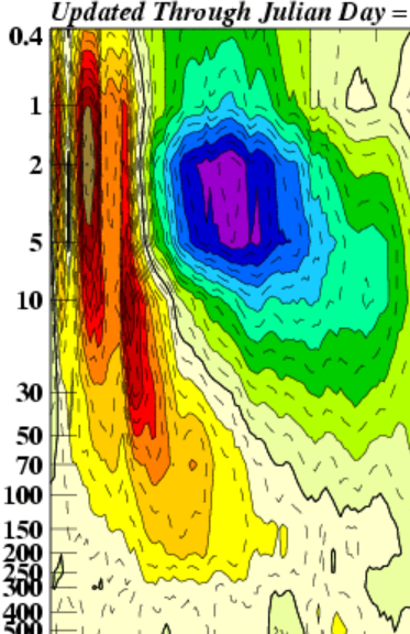
-
2026-2027 Record-breaking El Nino
LakePaste25 replied to Stormchaserchuck1's topic in Weather Forecasting and Discussion
Models keep it going far longer than “a few days.” Sure we can see if they verify first, but if it persists then it’s the December Nino pattern a full month early. -
Whatever it takes.
-
2026-2027 Record-breaking El Nino
LakePaste25 replied to Stormchaserchuck1's topic in Weather Forecasting and Discussion
Completely disagree.