All Activity
- Past hour
-

December 2025 regional war/obs/disco thread
moneypitmike replied to Torch Tiger's topic in New England
Good news is we can cool down before the Sunday/Monday event. -

26th-27th event, coming at us like a wounded duck.
WinterWolf replied to Go Kart Mozart's topic in New England
Modeling can’t seem to get a grip on anything…and now the big blocking just seems to really be exacerbating it…so for sure, we are weary. -
16.5” and looks like another band has formed and trying to sink SE
-
Brian, you got more snow than me. 5.25" final. (around 17" season) I thought I would have had a bit more being slightly closer to the Norlan? Merry Christmas to all.
-

White Christmas Miracle? December 23-24th
TauntonBlizzard2013 replied to Baroclinic Zone's topic in New England
Hopefully you and Jeff can post a few more snow maps before this event ends. Must be a couple more out there. -
When the precip started even the central Jersey shore was 34 degrees while Manhattan was showing 37 so yeah definitely was the HIE.
-

White Christmas Miracle? December 23-24th
Great Snow 1717 replied to Baroclinic Zone's topic in New England
Final tally from Rainthuen 1.6...fortunately the bulk of the precip came during late afternoon and evening -

26th-27th event, coming at us like a wounded duck.
Kitz Craver replied to Go Kart Mozart's topic in New England
Definitely an improvement from yesterday, but I have to have pause. Modeling can’t get a grip on the blocking so buyer beware -
White Christmas Miracle? December 23-24th
PowderBeard replied to Baroclinic Zone's topic in New England
This is nuts. -
December 2025 regional war/obs/disco thread
moneypitmike replied to Torch Tiger's topic in New England
Snow to rain for mi casa. -

2025-2026 ENSO
40/70 Benchmark replied to 40/70 Benchmark's topic in Weather Forecasting and Discussion
Some folks need to practice staying out of "defense mode" when someone else insinuates that they may be wrong, and/or have bias....I know it's tough to do, but when you own shit like that, not only is it better for your own mental health and prospects for personal enrichment moving forward, but it disarms the other side entirely, and avoids the OT bickering that derails these threads. I have bias, and am often wrong...it's called being human. It's also fine if you don't actually agree that you are wrong....just tactfully explain it and the other side remains venomous, then they look like the ass. -

26th-27th event, coming at us like a wounded duck.
UnitedWx replied to Go Kart Mozart's topic in New England
Euro is slowly improving. Lets keep that up, and get some others onboard. We really don't need anything dramatic, just increments. I'll admit, I really thought this was toast, but it's certainly still there -
White Christmas Miracle? December 23-24th
WinterWolf replied to Baroclinic Zone's topic in New England
Six inches…shovel it. The exercise will be beneficial. If you had a a foot…then of course blow it. -
White Christmas Miracle? December 23-24th
moneypitmike replied to Baroclinic Zone's topic in New England
Is that Jeff in the woods pointing the gun? -
Something is up with the Srefs. Next to no snow up north and precip is mainly across the MA. Check out Pivotal maps for latest 2 runs. Gotta be wrong. Here's the link to 9z total qpf off Srefs. https://www.pivotalweather.com/model.php?m=srefens&p=qpf_acc-mean-imp&rh=2025122409&fh=87&r=conus&dpdt=&mc=&pwplus=1
-
White Christmas Miracle? December 23-24th
WinterWolf replied to Baroclinic Zone's topic in New England
That’s a nice haul. Big white Xmas for you. -
Not sure what your point is. The NBM and NWS maps for yesterday were quite good, except for NYC proper, where it was slightly warmer and little accumulation occurred. I'm 25 miles SW of CPK along 95 and got 0.8" vs. a 0.5" prediction - the only reason I can think of why NYC didn't get accumulation was the heat island effect.
-
I wouldn't be surprised if temperatures dropped to low 20's with those dynamics! saturday morning will look and feel like north pole
-

White Christmas Miracle? December 23-24th
dendrite replied to Baroclinic Zone's topic in New England
It’s easy to forget how potent these events can be given the inverted flake jokes. But when a real deal norlun comes around they can dump over a good area in a short amount of time. It’s on that borderline of shovel or snowblow for me. If I snowblow I leave an inch that gets packed down and turns to ice or I bust my ass to get it near dirt level. -
2025-2026 ENSO
40/70 Benchmark replied to 40/70 Benchmark's topic in Weather Forecasting and Discussion
Yea, I declared a mea culpa on that last night....I was wrong on latter December blocking, though did get the emergence of Pacific troughing right...end result is I will be too warm for December. and maybe January. The stat warming last month was more impactful than I had theorized. -
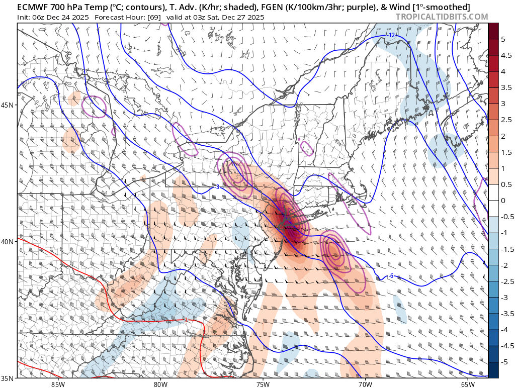
The Euro is showing this coming in as a wall of heavy snow scenario where the best spots for banding can pick up 3-6” of snow in 3-4 hours with excellent rates.

-

26th-27th event, coming at us like a wounded duck.
weatherwiz replied to Go Kart Mozart's topic in New England
I like what Ryan said yesterday in that we would probably see a more consolidated band of heaver snow than what is shown. Aloft this kind of looks like crap. Have to fire up bufkit but some of the forecast soundings on the northern side of that precip shield look like crap...even within Fairfield County which I was thinking could have some potential for several inches. But still too much uncertainty to really have any concrete thoughts and that blocking we can't discount. Hopefully we'll get a bit more clarity with the 12z suite. -
2025-2026 ENSO
40/70 Benchmark replied to 40/70 Benchmark's topic in Weather Forecasting and Discussion
Strong PV doesn't necessarily mean "torch", either... -
2025-2026 ENSO
40/70 Benchmark replied to 40/70 Benchmark's topic in Weather Forecasting and Discussion
Dude, we need less of this in the thread. Just disagree and move on... -
Agreed. I am not seeing much NW movement of the models, just movement of the heaviest snow which unfortunately is a fairly narrow band.