All Activity
- Past hour
-

Strong Nor'Easter/Hybrid Storm Late September 2026
NJwx85 replied to Rjay's topic in New York City Metro
Very rainy and windy overnight in Rockland. More heavy rain tonight and at least another 24 hours of this to go. -
 5.84. Most impressive rain event in my 8 years at my current local
 -

October Comes Early: Late September Multi-Hazard Hybrid Storm
vortex95 replied to WxWatcher007's topic in New England
Got it! Recall the G113 mph Oct 2021!? -
 Definitely gusted 50-55 all over this area in the hilly terrain
 -
All my data is dead nuts on. Those that have weather stations understand . You don’t have one in your little wood pit there so you make stuff up and lash out at those that appreciate official data and science
-
October Comes Early: Late September Multi-Hazard Hybrid Storm
vortex95 replied to WxWatcher007's topic in New England
WE +RA! -
October Comes Early: Late September Multi-Hazard Hybrid Storm
vortex95 replied to WxWatcher007's topic in New England
Worth it? You might think differently when you do not have power for a month! -

October Comes Early: Late September Multi-Hazard Hybrid Storm
CoastalWx replied to WxWatcher007's topic in New England
Good storm for this time of year for sure. You never see 50kts in September from a coastal. Looks like back areas will have over 8” rain by later tomorrow. Probably from Wareham to Desperate Housewives. -
.thumb.gif.f92b16c631a1d15d405ed77b33f0710d.gif)
October Comes Early: Late September Multi-Hazard Hybrid Storm
Torch Tiger replied to WxWatcher007's topic in New England
Pedestrian -
.35” here, lots of smaller branch’s, 4-6’ long, down in the yard and driveway.
-
2026 Atlantic Hurricane Season
vortex95 replied to Stormchaserchuck1's topic in Tropical Headquarters
The ACE value CSU found for 1933 comes from HURDAT2 reanalysis. They noted an increase in ACE from 213 (original HURDAT) to 259 (reanalyzed HURDAT2). See here: https://journals.ametsoc.org/view/journals/bams/102/3/BAMS-D-19-0330.1.xml -
Heavy rain and by far strongest winds of the event this am. Wind into mid 30s.
-

October Comes Early: Late September Multi-Hazard Hybrid Storm
Ginx snewx replied to WxWatcher007's topic in New England
Right into our winter pattern love it -

October Comes Early: Late September Multi-Hazard Hybrid Storm
Lava Rock replied to WxWatcher007's topic in New England
0.15". Sent from my SM-S921U using Tapatalk -
October Comes Early: Late September Multi-Hazard Hybrid Storm
Ginx snewx replied to WxWatcher007's topic in New England
TMEH! -

Strong Nor'Easter/Hybrid Storm Late September 2026
TWCCraig replied to Rjay's topic in New York City Metro
Amazing looking satellite. Reminds me of the blizzard of 2006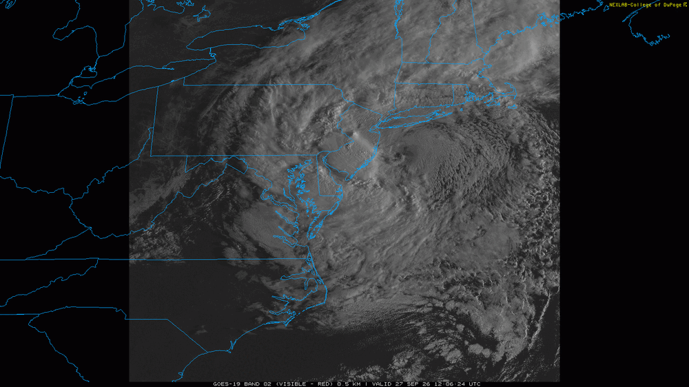
-

October Comes Early: Late September Multi-Hazard Hybrid Storm
TalcottWx replied to WxWatcher007's topic in New England
LOL -
0.31", 0.62" event total
-
Many times I’m not, but calling out the wind of this thing was an easy one. We always underperform winds here.
-
October Comes Early: Late September Multi-Hazard Hybrid Storm
CoastalWx replied to WxWatcher007's topic in New England
You’re never right -
Got into a firehose. Just soaked. Wind sucked, I was right about that
-

2026-2027 Record-breaking El Nino
bluewave replied to Stormchaserchuck1's topic in Weather Forecasting and Discussion
This may be the first time so early in the season that a low during and El Niño year backed all the way into the Jersey Shore from the east. The perfect storm back in October 1991 looped offshore but didn’t make it all the way back to the coast. The January 1992 storm backed in off the ocean into the Delmarva. But the Christmas 1994 subtropical low did make it all the way back to the coast from the east. These patterns are mostly a result of very strong 500 mb ridging north of the Great Lakes preventing the storms from escaping to the east of Cape Cod like we usually see with coastal low tracks. This month the record ridge over the south was able to build north of the Great Lakes resulting in the capture of the east coast storm. Now the recurving typhoons are giving us a strong +WPO +EPO pattern in early October which we typically see during La Niña patterns this time of year. But this is only a snapshot of early October and could shift again mid to late month. -

October Comes Early: Late September Multi-Hazard Hybrid Storm
SouthCoastMA replied to WxWatcher007's topic in New England
Oh I don't even use mine for wind. it sits about 6ft above the roof ridge and it still underestimates by over 50%. I'm guessing trees and roof turbulence. I do have a handheld but you need to be in an open area like a field or beach. Could also be an issue with the device itself but I haven't bothered to inspect it after I installed. -

October Comes Early: Late September Multi-Hazard Hybrid Storm
kdxken replied to WxWatcher007's topic in New England
I would be looking for a new money pit. This isn't going to help. -
October Comes Early: Late September Multi-Hazard Hybrid Storm
CoastalWx replied to WxWatcher007's topic in New England
What a clown. Man bow the fuck down.